2019:474 - READSLAND, ROESTOWN AND KNOCKS, Meath
County: Meath
Site name: READSLAND, ROESTOWN AND KNOCKS
Sites and Monuments Record No.: N/A
Licence number: 15E0125
Author: Steven McGlade, Archaeology Plan
Author/Organisation Address: 32 Fitzwilliam Place, Dublin 2
Site type: Burial ground, Metalworking site, Kiln - corn-drying and Settlement cluster
Period/Dating: Early Medieval (AD 400-AD 1099)
ITM: E 695960m, N 752865m
Latitude, Longitude (decimal degrees): 53.516991, -6.553044
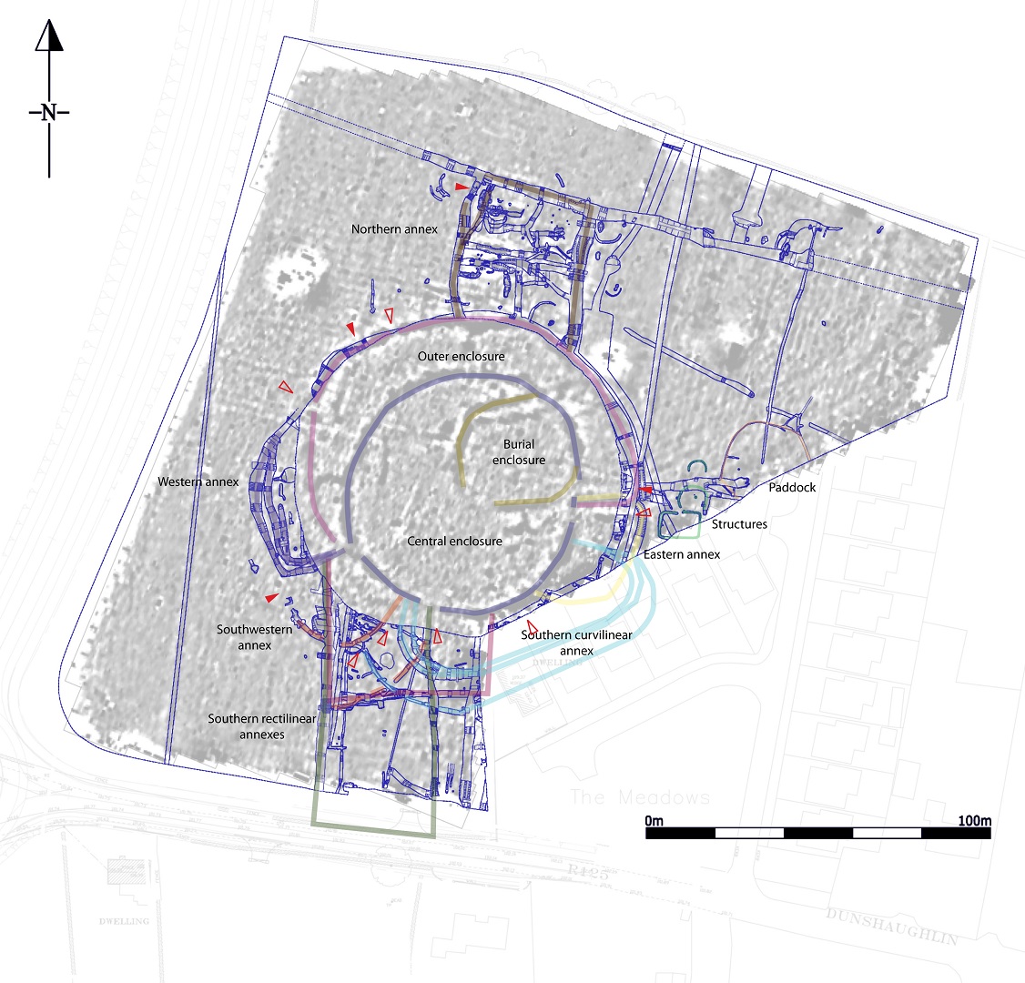
Monitoring and subsequent excavation of Phase 2 of the development at Readsland, Roestown and Knocks began in June 2018 and was completed in February 2019. The summary for Phase 1 has been entered separately. An early medieval cemetery-settlement was identified within Phase 2 of the development during the initial geophysical survey and testing carried out on the site in 2009 (09E0214). The development was subsequently redesigned to preserve the central enclosure of the settlement in situ. The central enclosure measured c. 68m in diameter, with the burial enclosure measuring c. 38m by 34m off-centre to the north-east. The outer enclosure was not concentric to the central enclosure, forming a crescent-shaped enclosure to the north measuring c. 84m by 96m. The ditch forming the outer enclosure was encountered and excavated during the excavation, however the interior of the outer enclosure was preserved in situ.
The 2018–9 excavations uncovered a series of enclosures and annexes on all sides of the central settlement enclosure. Both rectilinear annexes and crescent-shaped annexes were identified, which evolved and were expanded or replaced throughout the lifetime of the settlement. A number of entrances were identified associated with the annexes, with a masonry entrance feature to the north-west being the best surviving example.

A substantial ironworking area was uncovered in the northern annex with over a tonne of metallurgical waste retrieved during the course of the excavation. At least eight separate furnaces were identified, along with a further eight probable furnaces, and additional metalworking features. A rectangular structure, possibly a smithy, was represented by a drip gully measuring c. 6.9m by 3.1m with a central pit and two post-holes along the line of the drip gully to the west suggesting an entrance. A large anvil stone was retrieved in the vicinity of the structure during the monitoring phase. Large linear waste pits were uncovered in the vicinity of the metalworking area. A substantial programme of post-excavation analysis on this material is being carried out by Brendan O’Neill in UCD.
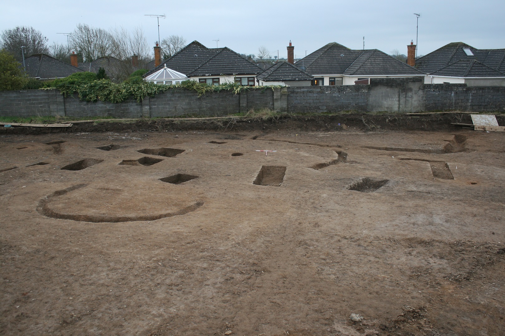
Twenty-five cereal-drying kilns were uncovered across the site, many with associated windbreaks. These are indicative of the longevity of the site, however the kiln activity culminated in a series of five large intercutting kilns with a large associated waste pit cut into the former annex ditch representing a substantial intensification in production. A circular structure measuring 6.8m in diameter was uncovered beside one of the kilns to the south and may represent a barn or store.
A cluster of structures was uncovered in the unenclosed space near one of the settlement entrances. Two of these were circular and may have formed a figure-of-eight structure or two separate circular structures. The larger of the two measured 7.25m in diameter and had a large central post-hole. The smaller slot trench had a diameter of 4.5m, giving it the correct proportions for a ‘backhouse’. A large rectangular structure was also uncovered, partially continuing beyond the limit of excavation. The rectangular structure was orientated east-west with an entrance to the north facing the entrance to the larger circular structure. It measured 10.7m x 6.75m, with an internal area of 72m2. A 9th–10th-century Scandinavian iron hand bell was retrieved from the rectangular structure. No internal post-holes were identified, though a possible post-pad was identified midway along one side. The rectangular structure is comparable with the largest of the houses uncovered in Viking Dublin, however these had their entrances in the gable ends.
The presence of these buildings in unenclosed ground outside the settlement enclosures is intriguing. They were located at one of the main entrances into the settlement and were connected to it with a pathway. They may represent accommodation provided for those visiting the settlement such as a hostel or guest house. Close to the structures a large space enclosed by a slot trench and containing a metalled surface was uncovered, which may have been an enclosed field or paddock, which may have been used to tie up the animals of those visiting the settlement. Given the rectangular form it is also possible the latter structure represents a religious structure as the pathway leading in towards the settlement would have connected to the burial enclosure. It is also possible that other activities needed to be carried out at a remove from the main settlement, or with people that were not allowed access to it.
Metalled paths were identified across the site relating to various phases of the site’s development, some connecting the settlement with the wider community and others traversing the settlement itself. The ditches defining the main settlement and multiple annexes contain numerous entrances. Overall, the numerous entrances and paths in and around the settlement do not suggest a strong consideration for defence.
No additional burials were encountered during the excavation indicating the burials were contained within the preserved portion of the settlement. A fragment of human skull of a juvenile was retrieved from the base of the annex ditch to the south-west. This may have been displaced from the burial ground, however, given the lack of human bone from elsewhere on the site it is possible this was an intentional deposit.
A number of artefacts were retrieved during the excavation of the early medieval settlement, with the key examples being a stone gaming board, a cross-inscribed stone, a c. 10th-century copper-alloy ring-pin, decorated copper-alloy fixings, glass and amber beads, fragments of glass and lignite bracelets, bone combs, and the iron hand-bell. A number of the artefacts have direct comparison with material from Lagore Crannog, Roestown 2, and from Viking Dublin, indicating the outer annexes and enclosures of the settlement were active during the latter centuries of the early medieval period. The small fragment of glass bangle is identical to a Type 2 Bii Romano-British glass bangle, and an identical example was retrieved from Lagore. The fragment was uncovered within the backfill of one of the metalworking furnaces and may have been intended as a decorative insert or stud. It is possible the bangle relates to the earlier activity at Lagore and was brought to the Readsland site for use in the metal production.
This substantial cemetery-settlement site would have been located within the Kingdom of Lagore and would have been inter-visible with the ecclesiastic settlement of Domhnach Sechnaill. Given the presence of a presumably secular graveyard within the central enclosure it is more likely that the settlement was associated with Lagore. The settlement had commanding views to the south and west to the Skane River, which would have been an important territorial boundary. Based on the date of many of the finds from the excavation the settlement experienced a jump in activity in the 10th–11th centuries. The Mac Gilla Sechnaill established themselves in a sub-kingdom approximately coterminous with the baronies of Upper Deece and Ratoath by the 11th century, with their stronghold believed to be in the vicinity of the ecclesiastic settlement of Domhnach Sechnaill (Bhreathnach 1999, 4). Perhaps the late flurry of activity at Readsland is associated with this political dynasty?
Post-excavation analyses are ongoing and a suite of radiocarbon dates will be sought for both Phases 1 and 2 of the excavation. The preliminary report of the excavation will be available to download from our website (www.archaeologyplan.com) in due course.
Reference
Bhreathnach, E. 1999 ‘Authority and supremacy in Tara and its hinterland c. 950–1200’, in Discovery Programme Report 5, pp. 1-24.