2019:038 - CAULSTOWN/CARRONSTOWN, Meath
County: Meath
Site name: CAULSTOWN/CARRONSTOWN
Sites and Monuments Record No.: N/A
Licence number: 19E0019
Author: Margaret McCarthy, ARCHAEOLOGICAL CONSULTANT
Author/Organisation Address: Rostellan, Midleton, Co. Cork
Site type: Burnt spread
Period/Dating: —
ITM: E 706657m, N 770750m
Latitude, Longitude (decimal degrees): 53.675591, -6.385699
A test excavation was requested as further information by Meath County Council for a proposed development in Caulstown townland, 2km north-east of Duleek. Two redundant archaeological monument records were originally recorded for the proposed development lands; one (ME027-079) located within the boundary of the proposed development, the other (ME027-078) in a field to the immediate north-west. Geophysical and LiDAR imagery surveys by the Department of Archaeology, University College Dublin in 2016 revealed that a substantial embanked enclosure (c. 120m internal diameter) exists at the location of the two sites that were originally registered as redundant records. The National Monuments Service was notified of the existence of the henge-type monument in 2018 and it has now been classified as an embanked enclosure (ME027-078) defined by a broad bank feature with an external diameter of 200m.
It was recommended in the Archaeology, Architecture and Cultural Heritage Chapter prepared for the EIAR in 2018 that further geophysical survey be carried out and this was undertaken in November 2018. The gradiometer survey did not show any trace of the bank for the large henge-type enclosure that is so clearly visible on the LiDAR imergery but it did identify a probable enclosure (ME027-078001) inside its perimeter and another less certain feature to the south. A number of potential archaeological features were identified in other areas of the field proposed for development and some of these were recognised during the test excavation.
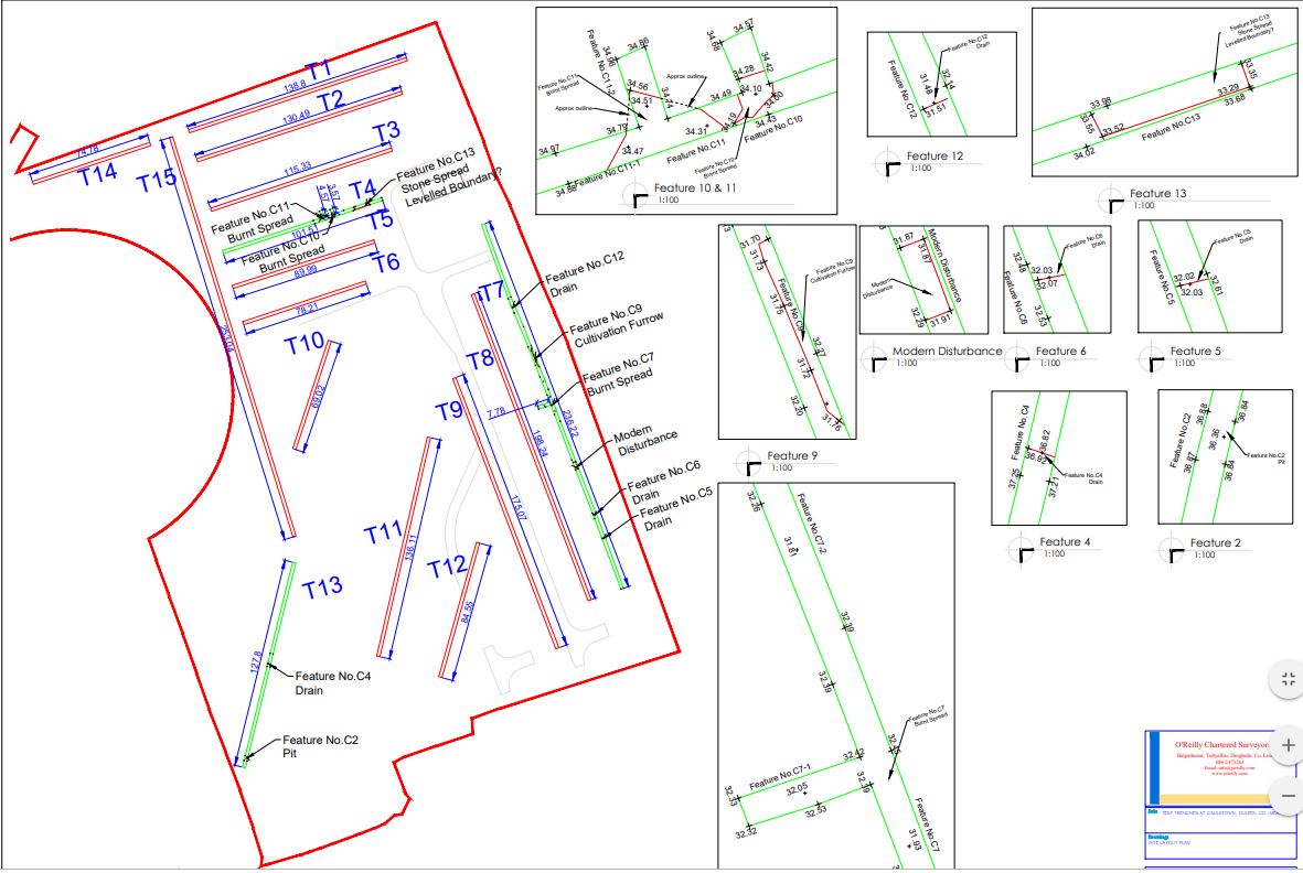
The test excavation of the proposed development lands was undertaken in March 2019. In all, 15 trenches were placed across the field and a number of archaeological features were uncovered in three of the excavated areas. Two spreads of black charcoal-enriched soil were identified in Trench 4, located in the central area of the field. One (C10) measures 2.2m east-west x 1.9m and another (C11) 5.8m east-west x 3.2m. At the east side of this trench, a broad concentrated spread of stone (C13) may represent the remnants of a former field boundary indicated on the LiDAR image extending north-south through the centre of the field. In Trench 7, adjacent to the east boundary of the proposed development site, a spread of black charcoal-enriched soil containing frequent heat-fractured stones (C7) was uncovered. It measures 3.3m north-south x 2.1m. Three east-west-running modern land drains were also exposed across this trench along with a shallow linear feature (C9), interpreted as a possible cultivation furrow. A localised spread of charcoal-enriched soil (C2)was uncovered in Trench 13 in the south-west corner of the field. This was manually cleaned and half-sectioned to reveal the presence of a shallow oval-shaped feature measuring 0.58m east-west x 0.49m with a maximum depth of 0.17m.
In conclusion, a test excavation in lands to the immediate east of the embanked enclosure (ME027-078) in Caulstown townland uncovered three localised spreads of heat-fractured stone. Th test excavation was requested as an RFI from Meath County Council and a decision has yet to be made on a grant of planning permission. Direct impacts to the archaeological features uncovered during testing and to potentially further undocumented sub-surface archaeological remains have been identified and appropriate mitigation has been recommended.