2019:706 - ARDOUGHAN, Mayo
County: Mayo
Site name: ARDOUGHAN
Sites and Monuments Record No.: RMP Nos. MA030-098, MA030-099
Licence number: 19E0138
Author: Richard Crumlish
Author/Organisation Address: 4 Lecka Grove, Castlebar Road, Ballinrobe, County Mayo
Site type: Fulacht fia
Period/Dating: Prehistoric (12700 BC-AD 400)
ITM: E 523175m, N 819598m
Latitude, Longitude (decimal degrees): 54.119687, -9.175156
The testing uncovered two burnt spreads (F1 and F2) with four more test trenches subsequently opened to further investigate the features. The burnt spreads were located 0.15–0.4m below the surface and consisted of blackened soil which contained heat-shattered rocks and charcoal. Following the submission of the testing report, Mayo County Council requested the full excavation of both features.
The two features (F1 and F2) were located 20m apart, close to the base of an east-facing slope, near the east side of the proposed development site in a large field of pasture. Prior to the testing there was no surface trace visible.
Two cuttings (BB and CC) were opened manually to investigate the features (F2 and F1 respectively). Cutting BB measured 8–10.7m north-south by 5.1–8.4m. Cutting CC measured 12.75–12.9m north-south by 9.2–10.2m. The two fulachta fiadh (F1 and F2) were fully excavated, revealing two troughs (F8 and F5) and two associated pits (F7 and F6). No artefacts were recovered.
The smaller mound, F2, was roughly horseshoe-shaped in plan and opened to the east. It measured 8.2m north-south by 2.5–5.2m and up to 0.33m thick.
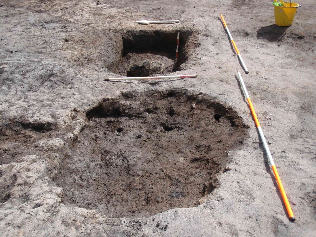
A roughly rectangular-shaped trough, F5, was centrally located within the mound (F2) and measured 1.6m west-north-west/east-south-east by 1.35m and 0.27–0.33m deep. It was cut into the natural subsoil and filled with burnt mound material and an an orange/brown plastic clay. Within the trough were three post-holes, two in the west-south-west corner and one in the north-north-west corner. All three post-holes were filled with burnt mound material.
A plectrum-shaped pit, F6, was located 1.7m north-east of the trough (F5) and measured 1.28m north-south by 0.5–1.15m and 0.22–0.36m deep. The pit was cut into the natural subsoil and was filled with a black friable silt loam which contained flecks of charcoal, above burnt mound material.
An enigmatic oval-shaped feature, F4, was located near the southern end of the east side of the cutting (BB). It consisted of a shallow ditch which enclosed an area measuring 2.5m north-west/south-east by 2m. The ditch was irregular in section and measured 0.15–0.55m wide and 0.1–0.2m deep. It was filled with topsoil and black friable silt loam which contained charcoal flecks.
The larger burnt mound, F1, was horseshoe-shaped in plan and and opened to the east. It measured 10.65m north-south bu 5.7–7.8m and up to 0.35m thick.
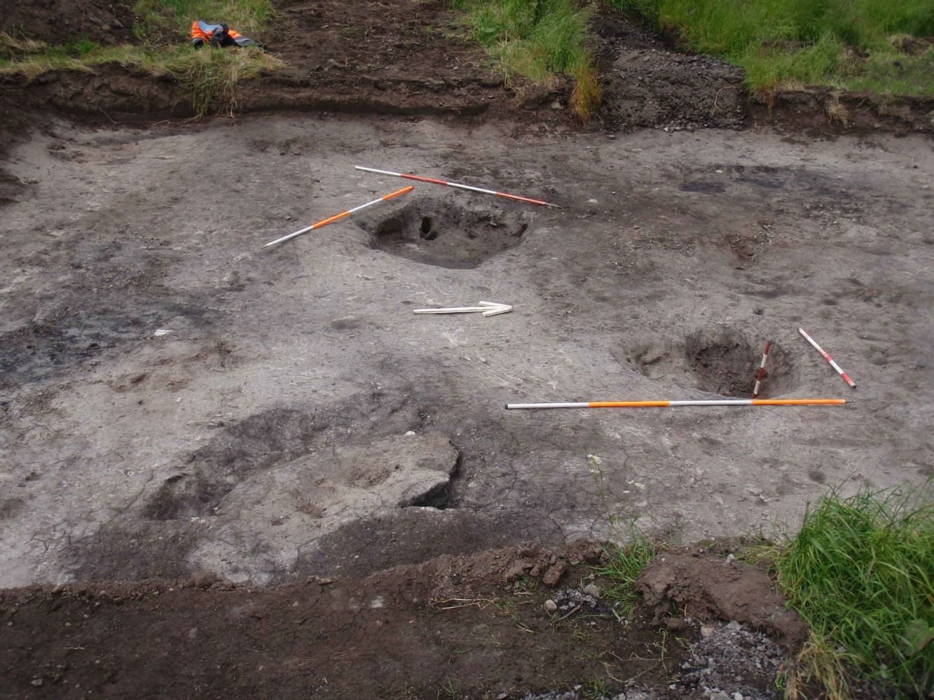
A plectrum-shaped pit, F7, was centrally located within the mound (F1) and measured 1.8m east-west by 1.0–1.5m and 0.16–0.27m deep. The pit was filled with burnt mound material and contained three stake-holes. The stake-holes were located in a north-north-west/south-south-east line in the eastern half of the pit.
The trough, F8, was located 0.5m east of the pit (F7) and measured 1.6m east-west by 0.95–1.0m wide and 0.3–0.5m deep. It was filled with a thin layer of burnt mound material, above re-deposited natural subsoil, above more burnt mound material. A large, partly heat-shattered, boulder was found centrally located in the western half of the trough at its base.
Two rows of stake-holes, totaling seventeen, located 0.2-0.4m apart and orientated east-north-east/west-south-west, were visible to the north of the trough (F8), possibly indicating the location of a windbreak. The stake-holes measured 30–70mm in diameter and 20–120mm deep. They were oval, sub-circular or roughly triangular in plan and were filled with dark brown organic material.
Four charcoal samples taken from the two troughs and two pits produced radiocarbon dates which ranged from the early centuries of the first millennium to the middle of the second millennium BC and clearly indicated that the larger of the two mounds, F1, was the older.
The smaller mound, F2, is numbered RMP MA030-098, while the larger mound, F1, is RMP MA030-099.