2019:125 - POLLSHARVOGE AND CLOONGULLAUN,, Mayo
County: Mayo
Site name: POLLSHARVOGE AND CLOONGULLAUN,
Sites and Monuments Record No.: N/A
Licence number: 19E0201
Author: Richard Gillespie
Author/Organisation Address: Mayo National Roads Office, Mayo County Council
Site type: Pit and Fulacht fia
Period/Dating: Prehistoric (12700 BC-AD 400)
ITM: E 534639m, N 801428m
Latitude, Longitude (decimal degrees): 53.958022, -8.995918
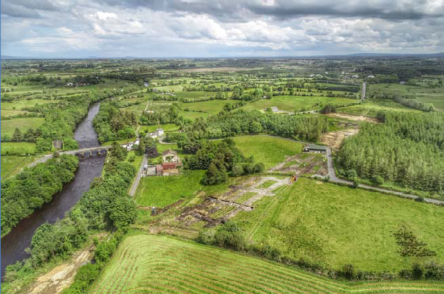
Test trenching was undertaken along the route of the proposed Realignment of the N26 at Cloongullane Bridge Project, Co. Mayo, between 1 May and 27 June 2019. The proposed road development includes the realignment of 1.8km of the N26 Foxford to Swinford Road at the Cloongullane Bridge, approximately 3.4km north-west of Swinford, Co. Mayo. The project is located in Cloongullaun and Pollsharvoge townlands. The area directly adjacent to Cloongullane Bridge is one of rich, flat grassland and alluvial forestry sloping down to the river Moy, which is consistent with a flood plain. However further to the east and west the land rises rapidly and here the land use is rough pasture and plantation forestry. The Moy River forms a natural boundary between Cloongullaun and Pollsharvoge townlands but has been straightened out sometime after the drawing of the second edition O.S. map (1893-00). This was most likely done during the Moy Drainage scheme in the 1960s and 1970s. During this scheme many rivers and streams within the Moy catchment were re-aligned and deepened and this may well have had a detrimental effect if any archaeology was present. This archaeological testing involved the mechanical excavation of test trenches with a combined length of over 6397m linear metres including greenfield and cleared woodland resulting in a total excavated area of 12,154m². This constitutes 11.8% of the area of the scheme excluding the existing road area.
During the test trenching, two archaeological sites were recorded: an isolated pit and a fulacht fiadh or burnt mound. The pit (ITM 535124/801215) in Cloongullaun townland is subcircular in plan measuring 1m north-south by 1.06m and c.0.2m deep. It was cut into the subsoil at a depth of 0.5 m below the current surface and is filled with relatively loose broken angular sandstones (possibly heat-affected) in a loose mid- to dark brown charcoal-flecked peaty clay. The pit was covered and carefully backfilled over to preserve it for full excavation. A fulacht fiadh (ITM 533785/801622) was identified in the north-west of a field in Pollsharvoge townland. It was to the south of a natural spring and cut by a curved drain. The mound consists of a dense concentration of heat-affected stone in a charcoal-rich matrix. It measures 6.5 m east-west by 11.5m (7.7m to the edge of the drain). The mound appears to rest on the natural boulder clay and has a maximum estimated thickness of 1m. No definite trough or other cut features were identified at this stage. The natural spring in the north-west quadrant of the mound has a concentration of stones which may be a built feature. These sites are located within the development area and will require full excavation in advance of construction.