2019:684 - DROGHEDA: Ballymakenny Road, Yellowbatter, Louth
County: Louth
Site name: DROGHEDA: Ballymakenny Road, Yellowbatter
Sites and Monuments Record No.: N/A
Licence number: 18E0733
Author: Derek Gallagher, Archaeological Consultancy Services Unit
Author/Organisation Address: Unit 21, Boyne Business Park, Greenhills, Drogheda, Co Louth
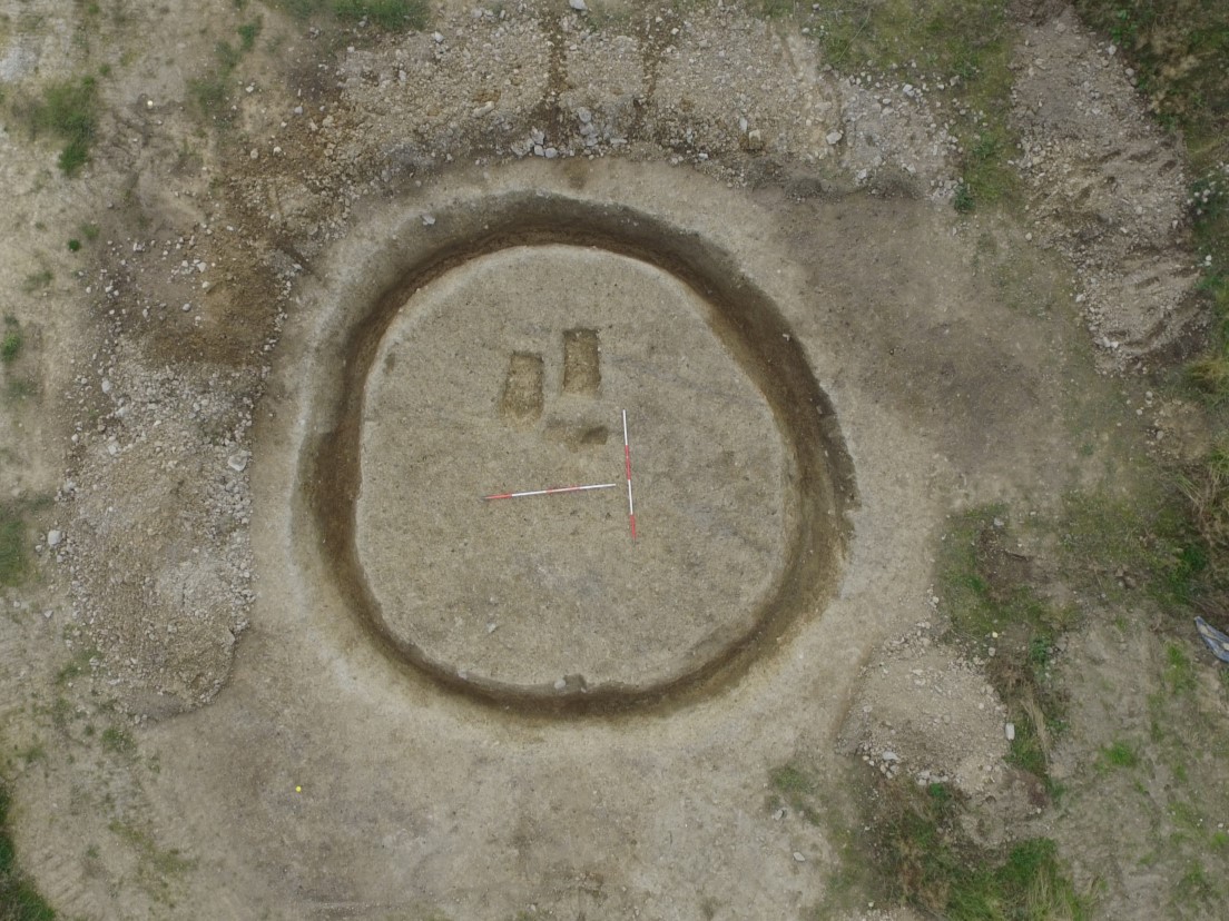
Site type: Ring-ditch and Urn burial
Period/Dating: Bronze Age (2200 BC-801 BC)
ITM: E 709365m, N 777609m
Latitude, Longitude (decimal degrees): 53.736644, -6.342310
The site at Ballymakeny Road, Yellowbatter, Drogheda, Co. Louth was subjected to a programme of archaeological monitoring (December 2018), a geophysical survey (18R0253), test-trenching and excavation (August 2019).
A total of 20 trenches were excavated. Each trench measured 1.8m in width and a total of 3,196m of linear trenches were excavated. In general, the trenches revealed a light brown sandy clay topsoil and sod at a combined depth of c.0.3–0.45m, overlying a mottled light grey/brown silty clay natural.
During these investigations, in line with the agreement with the Department of Culture, Heritage and Gaeltacht, the cremation burials (C03, C04) identified during monitoring of Phase 1 in December 2018 were block lifted, removed from site and fully excavated in the laboratory by a conservator. They were found to have been located within a small ringditch (C06), in addition to a pit (C21) which was located within the centre of the ringditch. Three pit-type features (C14, 16, C18) were also identified. These were located scattered within the site; there was no evidence they were directly related to the ringditch C06.
The geophysical survey (18R0253) identified a number of weak magnetic anomalies throughout the site. These were investigated during the test-trenching of the site and were found to represent modern agricultural features/furrows (C24, C23) and natural geology and are not of archaeological significance.
The ringditch was circular in plan and measured c. 8.3m in diameter (exterior) and comprised a relatively wide (max. 1.04m) and deep (max c 0.89m) ditch with a concave undulating base. Roughly centrally located was the pit C21, while two individual cremation pit burials within pottery vessels (C03, C04) were located in the eastern part of the interior. The cremation pit burials were initially discovered during monitoring, and were block lifted and excavated in laboratory conditions. The cremation C03 contained large pieces of cremated bone, and decorated rim sherd remains. The cremation C04 contained a substantial amount of cremated remains, and a full ring of ceramic rim survived with cord-impressed decoration. Both cremations were heavily truncated by ploughing. The remains in C03 represented an adult individual, however biological sex was indeterminate, while the remains in C04 contained an adult male. The mouths of the two inverted funerary vessels belonged to the Cordoned Urn Tradition, however sherds from at least four other, domestic vessels were found in the secondary fills of the ringditch C06. These were found in a layer that also contained Late Bronze Age pottery sherds from at least four to six pots. Overall, the site produced an assemblage of Early Bronze Age pottery representing six cordoned urns. It was suggested that the inverted cremation vessels were likely part of an Early Bronze Age flat cemetery that was disturbed by the later ringditch. It appears more likely however that the ringditch was broadly contemporary and directly related to the cremations within. The explanation for the differing dates of the pottery lies in the nature of the features. When a cremation (or cremations) was carried out in the Early Bronze Age (as suggestive by the vessel type), a mound was placed on top of the original burial pits/cremations. This was established by the digging of the substantial ringditch surrounding the features. The upstanding barrow was likely to be a recognisable burial monument in the landscape, and in later centuries was reused with the placement of further remains into the mound itself. The reuse of burial mounds in this way can be seen at such sites as the Mound of the Hostages on the Hill of Tara. When the mound degraded or was ploughed over, these later burials located within the mound were the ones disturbed, and hence the earlier and later pottery was incorporated into the ditch fills.
The evidence suggests that the site was in use intermittently from the Early Bronze Age to the Late Bronze Age. This appears to be in line with the dating of the pottery and lithics found on site and is further supported by radiocarbon dating. The inverted vessels found on the site have been classified as stylistically belonging to the period of 1570–1500BC. This roughly corresponds with the dating obtained from a sample of hazel charcoal (0.01g) from the primary fill of the ringditch that returned a date of 3150 +/- 30 BP, giving a 2 sigma calibrated date range of 1500–1310BC. Furthermore, a small, rounded thumb scraper with retouch and pressure flaking (18E0733:08:07) was found within the fills of the ringditch. This type of lithic can date from the Late Neolithic and Early Bronze Age c.2700–1600BC. Pottery sherds from the secondary fills of the ringditch were found to date to c.900–800BC. This supports the interpretation that the mound, prior to levelling, was used intermittently from the Early Bronze Age when it was constructed to the Late Bronze Age as suggested by sherd types. At a later stage, the mound was levelled and the material from the mound found its way into the ditch. The ringditch was further truncated during agricultural activity/ploughing as suggested by the presence of cultivation furrows.
All features exposed on the site were archaeologically excavated and resolved. All post-excavation analysis is now complete.