2019:197 - LIMERICK: Brown's Quay, Thomondgate, Limerick
County: Limerick
Site name: LIMERICK: Brown's Quay, Thomondgate
Sites and Monuments Record No.: N/A
Licence number: 19E0139
Author: Seán Shanahan & Marion Sutton, Shanarc Archaeology Ltd.
Author/Organisation Address: Unit 39a, Hebron Business Park, Hebron Road, Kilkenny
Site type: Historic town
Period/Dating: Multi-period
ITM: E 557448m, N 657939m
Latitude, Longitude (decimal degrees): 52.670948, -8.629151
Test excavations were carried out at Brown’s Quay, Thomondgate, Limerick, within the zone of archaeological potential for the historic town (LI005-017), prior to the proposed construction of a development comprising of a two-to-three storey apartment building and ancillary site development works.
The development site is situated on the west bank of the River Shannon, at the south end of Brown’s Quay, in the Thomondgate area of Limerick. The site is bounded to the east by Brown’s Quay, and by Cashel’s Lane to the west, in an area dominated by suburban residential development. Historically, the area was dominated by industry, and a 6-acre site on Brown’s Quay, extending northwards, was formerly occupied by the Walker’s Distillery. Little of the distillery survives.
Prior to test excavation, the site was cleared of buildings, boundary walls, rubble and modern concrete slabs. Demolished buildings included three derelict dwelling houses (and a fourth partly-demolished dwelling) and small sheds in the western part of the site, which slopes from Cashel’s Lane to the eastern part of the site, at the level of Brown’s Quay, which was occupied by two derelict garages (in an L-shape configuration) and two small sheds. Related planning documents describe the site as Collins’ Cottages, Cashel’s Lane and Duggans Yard, Brown’s Quay.
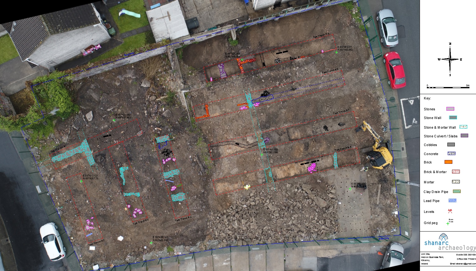
Test excavations were conducted on 20 May and 7 June 2019 and comprised eight test trenches measuring 1.8m in width, 0.1–1.5m in depth and 8–18m in length.
Testing established that sub-surface remains of 19th-century, and potentially earlier structures, with associated surfaces, are located at the site. It was possible to correlate many of the structural remains with buildings and yard walls recorded on the first and subsequent 19th- and early 20th-century edition Ordnance Survey maps. Wall remains that could not be correlated on Ordnance Survey maps may relate to older 18th-century building remains, such as wall remains in Test trench 3 and in the east end of Test trench 8. As buildings existed on the site in the mid-18th century, it is also possible some 19th-century footprints may have origins in the 18th century. Certainly, there are likely 18th-century deposits on the site, inclusive of a deposit that contained a 17th-18th-century North Devon gravelled tempered sherd in the north-west part of the site. Finds from the site consisted of 17th-20th-century pottery, animal bone, clay pipe fragments and glass bottles.
There appears to have been a connection between the development site and a large garden associated with the 19th-century Thomond Gate or Walker’s Distillery owner’s or manager’s house. The north-east part of the site encompasses part of the gardens, which was cut off during the construction of housing north of the current boundary wall. Surface features in this part of the site are likely associated with 20th-century sheds or greenhouses, which overlie features of an earlier date.