2019:868 - FRESHFORD: Kilkenny Street, Kilkenny
County: Kilkenny
Site name: FRESHFORD: Kilkenny Street
Sites and Monuments Record No.: KK013-023
Licence number: 18E0198; 18E0198 ext.
Author: Seán Shanahan, Marion Sutton & Maja Czechak; Shanarc Archaeology Ltd.
Author/Organisation Address: Unit 39a, Hebron Business Park, Hebron Road, Kilkenny
Site type: Burial
Period/Dating: Medieval (AD 400-AD 1600)
ITM: E 640705m, N 664766m
Latitude, Longitude (decimal degrees): 52.732447, -7.397311
Archaeological monitoring took place of excavations relating to the upgrade of the water mains infrastructure on Kilkenny Street (R693) in Freshford village, Co. Kilkenny from January through to March 2019. Water mains excavations were undertaken by Coffey Northumbrian Ltd. on behalf of Irish Water.
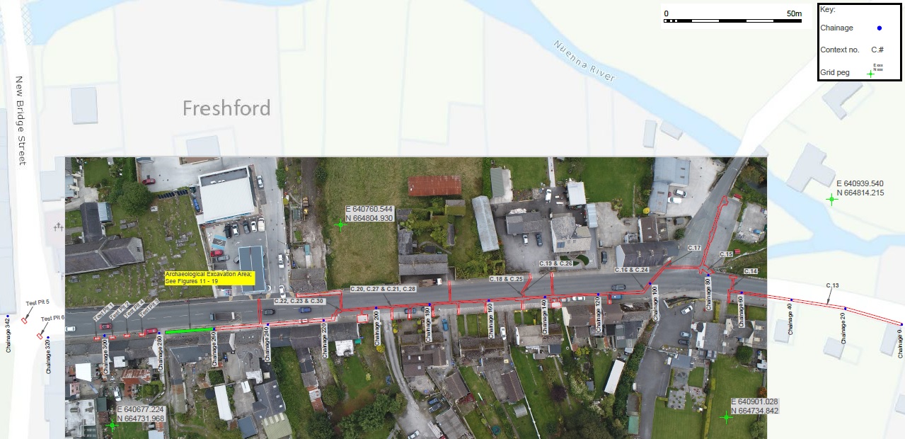
Monitoring was carried out over a distance of c. 280m from a point east of Prince’s Bridge on the R693 westwards along Kilkenny Street to a point opposite St Lachtain’s Church (KK013-023002) and Graveyard (KK013-023002), a church of medieval origin associated with an ecclesiastical settlement founded in Freshford in the 6th/early 7th century. Kilkenny Street is sited in its entirety within the Zone of Archaeological Potential for the historic town (KK013-023) at Freshford.
Human skeletal remains were identified in February 2019 during excavation of the mains trench in the footpath on the south side of Kilkenny Street, opposite St Lachtain’s Church and Graveyard. Following consultation with the project stakeholders, a method statement for the archaeological excavation of a 16m section of the mains trench was prepared and the human remains were excavated under an extension of licence 18E0198, in August and September 2019.
The exposed human remains, comprising disarticulated and articulated bone, were excavated to facilitate footpath reinstatement, and Irish Water revised its planned proposals, avoiding the burial location, to facilitate the preservation of the bulk of the remains in situ. Some evidence of burial truncation was recorded, suggesting the phasing of interments of possible early medieval and medieval/late medieval date. The discovery of the remains demonstrates that burials may be found outside, and to the south of the present graveyard curtilage at St Lachtain’s Church.
The human burial remains are sited to the south side of the present graveyard boundary wall, beneath the footpath to the south side of Kilkenny Street. The identified remains have been preserved in situ, the excavation having focussed on cleaning down, exposing and recording the remains prior to reinstatement of the footpath. To facilitate preservation in situ, Irish Water revised its planned proposals, terminating the mains trench to the east of the burials and tying-in to the existing mains to the north side of Kilkenny Street outside the present service station in the village.
The discovery of the human remains would suggest that burials may be found outside, and to the south of the present graveyard curtilage at St Lachtain’s Church, but perhaps not continuously; test pits excavated to determine the extent of the human remains to the south side of Kilkenny Street under licence 18E0198 did not expose burials to the westernmost extent of the street, towards the junction with The Mills and New Bridge Street, at ‘The Square.’
The excavation recorded some evidence of burial truncation, suggesting phasing of interments of early medieval and/or later medieval date. However, limited finds were recovered during the excavation to corroborate a date, the finds recovered being within C.03, a dark brown silty clay layer beneath the footpath make-up and generally above in–situ burial remains, a deposit of possible 18th – 19th-century date.
Elsewhere on the mains trench alignment, a feature of potential interest was a significant dished cut (C.27) uniformly filled with a fine, mid orange-brown silty clay (C. 20), a similar deposit to that (C.04/C.06) in which the human remains were recorded further west on the street. Possibly linear in nature, the feature’s provenance within the Zone of Archaeological Potential associated with the medieval ecclesiastical settlement raises the question as to its potential association with the ecclesiastical settlement. The limited nature of the trench excavation – a trench measuring 0.6m wide, where formation level did not expose the base of the feature – and a lack of artefactual evidence, makes interpretation difficult. The feature does not align with the conjectured location of a possible inner enclosing vallum associated with the ecclesiastical settlement.
Five possible pit features notably containing fragmented animal bone were also recorded along Kilkenny Street inside the Zone of Archaeological Potential associated with the medieval ecclesiastical settlement, where the trench moved from the road onto footpath to the south side of the street. Possible pit C.22 (C.23, C.30) was the largest of the dished features recorded, and the presence of a sewer pipe aligned east-west along Kilkenny Street below the level of the feature cut, to its northern edge, would indicate that it is potentially modern in date. This in turn may suggest that all similar pit cut and fill contexts recorded along Kilkenny Street are also modern in date, although again, the features lacked artefactual evidence to aid interpretation.
Other features recorded, a stone wall (C.15) and stone side drain (C.17) on Clintstown Road are interpreted as post-medieval in date, potentially associated with the 18th- and 19th-century layout of Freshford village.
The archaeological origin of two charcoal deposits (C.13, C.14) to the east side of the tributary stream entering the Nuenna River at the junction of Kilkenny Street and Clintstown Road is unsubstantiated, given the limitations of mains trench excavations and a lack of opportunity to investigate nature and extent.
Concurrent with the excavations, a metal detection survey (detection licence 19R0094) was carried out; this comprised the surveying of all extracted spoil from the excavation. Nineteen metal objects primarily comprising nails, were recovered during the metal detection survey.

