2019:773 - KILKENNY: Dean Street/James's Street/Blackmill Street/Butt's Green/Kennyswell Road, Kilkenny
County: Kilkenny
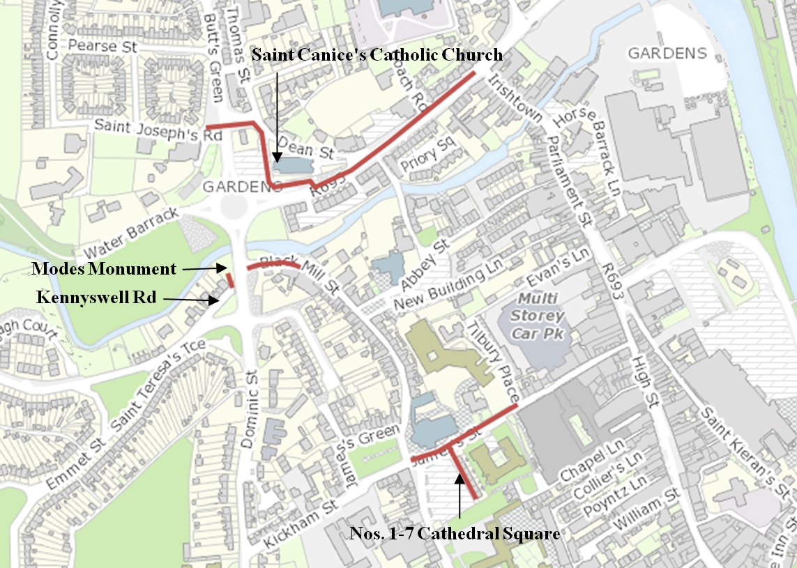
Site name: KILKENNY: Dean Street/James's Street/Blackmill Street/Butt's Green/Kennyswell Road
Sites and Monuments Record No.: KK019-026- / KK019-026001
Licence number: C000892, E005008
Author: Seán Shanahan & Marion Sutton; Shanarc Archaeology Ltd.
Author/Organisation Address: Unit 39a, Hebron Business Park, Hebron Road, Kilkenny
Site type: Historic town
Period/Dating: Multi-period
ITM: E 650304m, N 655945m
Latitude, Longitude (decimal degrees): 52.652364, -7.256546
Archaeological monitoring of site investigation and installation works associated with water infrastructure rehabilitation on Dean Street, Black Mill Street, Kennyswell Road and James’s Street in Kilkenny city was carried out under Ministerial Consent No. C000892 (Excavation Reg. E005008; Detection Device Reg. R000489).
Site investigation works were carried out in November and December 2018 and installation works from January through to May 2019.
Site investigation and installation works were undertaken within the Zone of Archaeological Potential for the historic town (KK019-026), and on Dean Street and James’s Street, within the Zone of Archaeological Potential for the medieval town defences (KK019-026001). Dean Street is also postulated as delineating the southern line of an ecclesiastical enclosure that surrounded the early-medieval Church of St Canice.
No remains of the medieval town defences (KK019-026001) were exposed during targeted archaeological testing or during subsequent mains installation at the locations of Dean’s Gate and James’s Gate. Likewise, no evidence representing a possible ecclesiastical enclosure on Dean Street was identified.
At Butt’s Green and at the Kennyswell Road cul-de-sac, in the small park fronting Dominic Street (site of the Modes Monument), infrastructural works were carried out at the recorded locations of a bullring (KK019-026026) and a water mill (KK019-026073), forming sub-elements of the historic town. No remains of these monuments were exposed during the works.
Potential features or deposits of archaeological interest were exposed in site investigation test pits TP06 and TP07 at the west end of Dean Street, from 1.1m below road level: masonry remains or rubble deposits were partially exposed at the south-west corner of TP06 and a black, sticky clay deposit with embedded stone and occasional brick fragments was recorded 1.1-1.15m below the current road surface in the south half of TP07. These remains were not re-exposed or impacted during subsequent installation works.
On James Street, the remains of a mortared stone wall remnant or structure remnant were exposed in site investigation test pit TP10 overlying redeposited material in the centre of the street, 0.43m below the current road level. The function of the feature, which remains in situ, is unknown. The width of the stone, at 0.3m wide, is similar to the dimensions of post-medieval culvert side walls recorded in a previous investigation at the nearby intersection of James’s Street and Black Mill Street. No base or corresponding side wall was identified in support of the interpretation that the feature formed part of a culvert. No further evidence of the feature was identified during mains installation, including during excavations of a perpendicular mains trench onto Cathedral Square to help corroborate its function. That it was not re-exposed demonstrates that the feature does not run (or survive) the length of James’s Street.
Older cobbled or metalled surfaces were identified on all four streets, recorded during site investigation works. These surfaces are generally interpreted as being post-medieval in date, although the deeper cobbled surface identified 0.8m below the current road level in Black Mill Street may well be early post-medieval in date. A cobbled surface is present 0.17m below the current street level on Kennyswell Road, and between 0.5-0.6m below the road level at the west end of Dean Street. No cobbled or metalled surface was identified in TP04, TP05 and TP08, which were excavated at the east end of the street, eastwards from the assumed line of the medieval town defences. A cobbled or metalled surface on James’s St is present 0.25m below the current road level.
In general, the water mains trench was installed in redeposited or mixed material, partly disturbed as a result of the installation of pre-existing services, from which a predominantly post-medieval finds assemblage was recovered, being generally 18th-20th century in date. The only confirmed medieval finds, 5 pottery and 2 tile fragments, largely Kilkenny-type ware (mid-13th-14th century), were recovered in redeposited material or an unstratified context on James’s St, with James’s St also notably being the source of the bulk of the finds assemblage.