2019:677 - SALLINS: Sallins National School, Kildare
County: Kildare
Site name: SALLINS: Sallins National School
Sites and Monuments Record No.: N/A
Licence number: 19E0189
Author: Tim Coughlan, IAC Archaeology
Author/Organisation Address: Kilcoole, Co. Wicklow
Site type: Burial and Enclosure
Period/Dating: Medieval (AD 400-AD 1600)
ITM: E 689250m, N 722808m
Latitude, Longitude (decimal degrees): 53.248128, -6.662680
The development area is located in the townland of Sallins, County Kildare, west of the existing St Laurence National School car park. The site is bracketed by the canal to the north and a railway line to the south. Previous to the current phase of works the site comprised undeveloped level greenfield with a small area of hard standing extending from the adjacent car park.
Analysis of aerial photographic coverage and satellite imagery of the site revealed a pasture mark within the footprint of the original proposed playing pitch, indicating the presence of a sub-surface semi-circular archaeological feature. It is c. 21.5m in diameter and may represents the remains of a prehistoric enclosure. The eastern part of the enclosure is located beneath the school car park and it is not clear if this part of the feature survives intact.
During 2004 human remains, comprising two disturbed skeletons, were identified during construction of the National School to the immediate east of the proposed playing pitch area. The remains were reviewed on site by the National Monuments Service and osteoarchaeologist, Laureen Buckley. A licence (04E1343) was granted for their retrieval to Victor Buckley. No locational information is currently available for these remains and they are not included in the Sites and Monuments Record for Kildare. The school principal recalled that the 2004 burials were found in the vicinity of the semi-circular feature noted above.
Archaeological monitoring of ground disturbances associated with the construction of an all-weather pitch at Sallins National School was undertaken over the course of three days between May and July 2019. During May 2019, a site investigation trench (22.5m long, north-south) was excavated within the proposed pitch area in order to identify the location of a water main crossing the site. The trench also crossed a sub-surface semi-circular feature identified in the Google Earth imagery for 2018 extending partially within the development area and under the school car park. The enclosure ditch was visible on the surface as the grass was greener where it followed the path of the ditch (C7). The fill of the ditch (C8) was exposed in the north and southern parts of the trench and lay directly beneath the sod. The north section of the ditch was investigated in order to ascertain an archaeological origin.
The ditch (C7) was 1.8m wide and 1.1m deep and contained three fills; an upper fill of orangey brown silty clay (C8), a middle fill of gravelly silty sand (C9), and a basal fill of stony gravelly sand (C10). An east–west aligned linear feature (C11) was also investigated, which was 0.9m in width. The charcoal-rich fill (C12) was investigated to a depth of 0.55m where a prehistoric stone axe rough-out (19E0189:12:1) was recovered. Investigation ceased at this point and the features were covered in plastic and the trench backfilled. Following the discovery it was decided to redesign the playing pitches in order to preserve the enclosure in situ. The watermain was not identified during the course of works.
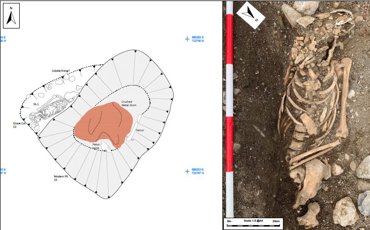
Archaeological monitoring of the removal of sod within the area of the proposed pitches took place between 1 and 5 July 2019. During the course of this work the remains of a human skull were identified within an irregular deposit of material measuring 1.2m east–west by 2.1m at ITM 689254, 722793.
The truncated remains of a single extended west–east inhumation burial was located in a simple grave that was cut into a localised sandy gravel deposit (C2). The burial was truncated on its south and east sides by a modern pit C5 that resulted in the removal of the right arm, pelvis and both lower limbs. The remaining elements were in moderate condition and completeness. The grave cut (C3) was not definitively identified due to the nature of the underlying loose gravel sandy silt and comparable grave fill. Cobbles aligned by the head and left arm may represent the remains of a disturbed stone grave lining. Preliminary review of the remains indicates an older adult male individual. An almost complete dental arcade is present which displays very heavy attrition levels across the anterior and posterior teeth. This extensive heavy wear pattern is indicative of a high level of grit in the diet (i.e. from stone-ground cereal).
A tooth from the skeleton was subject to Carbon 14 dating and returned a 2 sigma calibrated date of AD 344–536, placing it in the late Iron Age or early medieval period.