2019:544 - NAAS: Piper’s Hill, Kilcullen Road, Kildare
County: Kildare
Site name: NAAS: Piper’s Hill, Kilcullen Road
Sites and Monuments Record No.: N/A
Licence number: 14E0251
Author: Donald Murphy, Archaeological Consultancy Services Unit
Author/Organisation Address: Unit 21, Boyne Business Park, Greenhills, Drogheda, Co Louth
Site type: Enclosure, Souterrain, Structure and Kiln
Period/Dating: Multi-period
ITM: E 689147m, N 717163m
Latitude, Longitude (decimal degrees): 53.197427, -6.665801
Four separate areas of archaeology were identified and were recorded as Areas 1–4. These areas were excavated on a phased basis between 2014 and 2019 ahead of a proposed development site at Piper’s hill, Naas, Co. Kildare.
Area 1 was located 189m north-west of Area 2 and 248m south-west of Area 3. A circular slot trench (C06) and three post-holes (C08, C10 & C12) were identified within Area 1. These features represented the remnants of a house structure. Two of the post-holes represented support beams and the third probably represented a door post. A small iron dish (14E0251:07:1) was recovered from a metalled surface contained within the slot trench. A radiocarbon date was recovered from this house structure and dated it from the 5th–6th century AD.
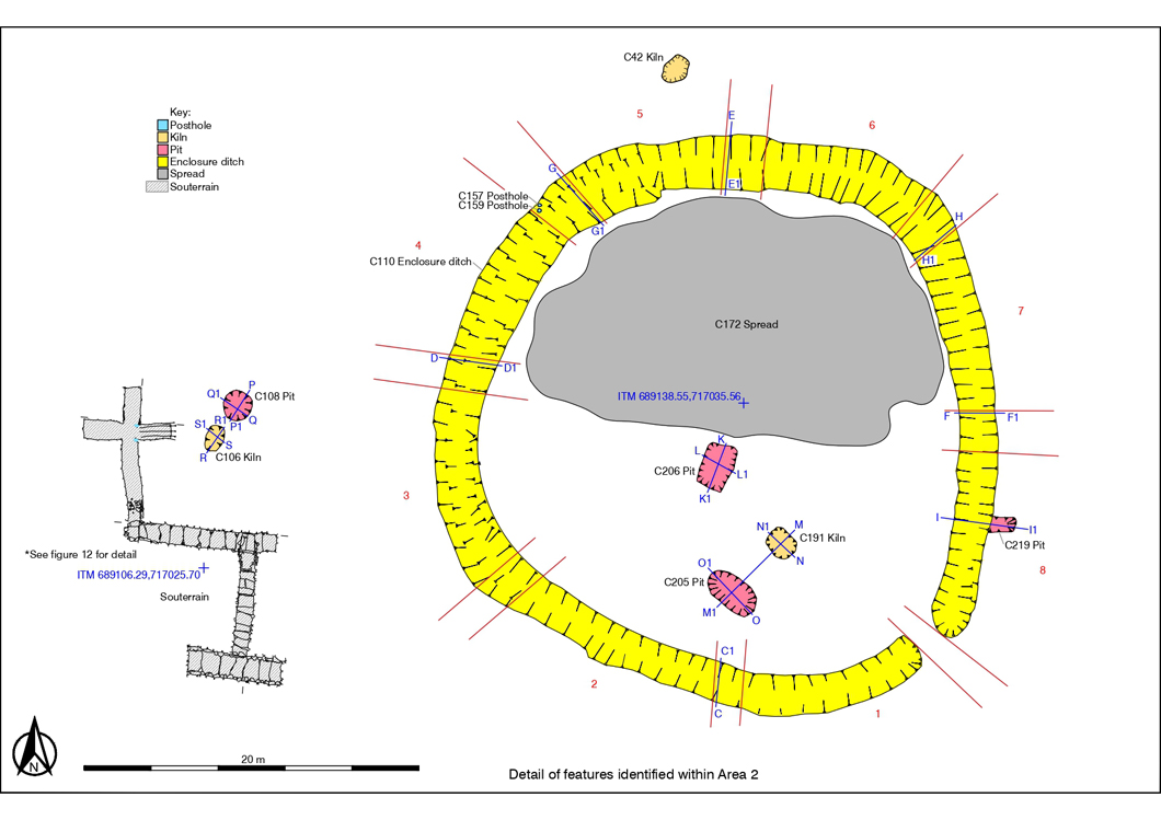
The features identified within Area 2 consisted of an enclosure ditch (C110), three kilns, five pits, one souterrain, four post-holes, one short linear cut and two spreads. Two features dominated this Area—the enclosure ditch C110 and the souterrain. The enclosure was approximately circular in shape and approximately 34m in diameter. It represented the remains of a ringfort. An entrance was located to the south-east. Internal features identified consisted of the spread C172, the kiln C191 and the two pits C205 and C206. The souterrain was located west of the ringfort C110. It consisted of a cruciform passage (1) containing two storage annexes to the north and west. At the southern end, a drop hole led to an east–west passage (2), which terminated to the east. A trapdoor in the roof of this passage provided access to a north–south passage (3) that also appeared to terminate a short distance to the south, however, a third trapdoor in the floor of this bridging passage permitted access to the remaining length of passage 3 and a rectangular-shaped chamber to the south. Two post-holes were located towards the entrance of the souterrain (C100 and C104). A radiocarbon date was recovered from the primary fill of the ringfort and dated this feature from the 3rd – 4th century AD. Radiocarbon dates were also obtained from the kiln C106 (adjacent to souterrain) and from the pit C219 (immediately east of ringfort) and were dated from the 3rd–6th century AD and the 4th–6th century AD respectively. Additional radiocarbon dates were obtained from the upper recut in the ringfort and from the post-hole C104 located at the entranceway of the souterrain and were dated from the 11th–13th century AD and 12th–13th century AD respectively. These features were therefore utilized by the same population and the date recovered from the upper fill of the ringfort attests to the longevity of usage of this enclosure site.
Area 3 was located in the north-east corner of the site, 325m north of Area 2 and 248m north-east of Area 1. Three kilns (C17,C23 & C28), one possible pit (C15), one spread (C32), a mettled surface (C30) and one non-archaeological feature (C31) were identified within Area 3. These three kilns were figure-of-eight in shape and were used as cereal-drying kilns.
Area 4 was located in the southeastern portion of the site, 59m south-east of Area 2. One cereal-drying kiln (C52, C93 & C236), four post-holes (C56, C58, C65 & C66), three ditches (C243, C244, C245), one curvilinear feature (C68), one hearth (C77) and one spread (C54 & C55) were identified within Area 4. The stone-lined L-shaped kiln consisted of a drying chamber (C93), a flue (C52) and a firepit (C236). A roughly square-shaped arrangement of four post-holes (C56, C58, C65 & C66) to the east of the kiln suggested the presence of a raised drying platform and both the kiln and drying platform were surrounded by the curvilinear feature (C68), most likely to prevent water from the surrounding hills washing into the kiln. Cereal grains were recovered from the majority of features within this area and a copper pin with a decorated head (14E0251:74:1) was recovered from the fill of the curvilinear feature C68. A radiocarbon date was obtained from this kiln and it was dated from 11th–12th century AD.
The features exposed would suggest the continued presence of a community within this site from the late Iron Age, Iron Age/early medieval transitional period and the early medieval period. The round house, souterrain and ringfort are features typically associated with early medieval settlement sites, as are cereal-drying kilns. Radiocarbon dating has also played an important role in confirming these dates and samples were recovered from Area 1, 2 and 4. The earliest radiocarbon date was recovered from the primary fill of the ringfort and dated it from Cal 240–390 AD (Area 2). The ringfort therefore represented the earliest known phase of activity within the site. The majority of ringforts excavated to date have been slightly later in date (c. AD 400–1100), making this ringfort particularly early in date.