2019:203 - ATHY: Geraldine Road, Clonmullin, Kildare
County: Kildare
Site name: ATHY: Geraldine Road, Clonmullin
Sites and Monuments Record No.: N/A
Licence number: 19E0356 ext.
Author: Michael Greiner & Marion Sutton, Shanarc Archaeology Ltd.
Author/Organisation Address: Unit 39a, Hebron Business Park, Hebron Road, Kilkenny
Site type: No archaeology found
Period/Dating: N/A
ITM: E 669027m, N 694675m
Latitude, Longitude (decimal degrees): 52.998344, -6.971691
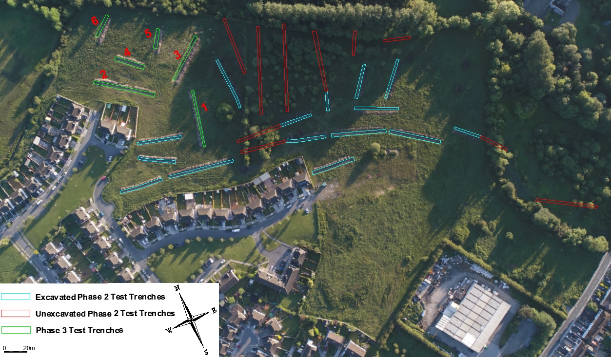
Testing was carried out on 19 and 20 June 2019 in relation to Phase 3 of a proposed 3-phase housing development at Geraldine Road, Clonmullin, Athy, in response to a further information request from Kildare County Council in respect of Planning Ref. 19/234.
The site is located in a greenfield environment in Clonmullin and Shamrocklodge townlands, on the edge of existing residential estates on the north-east side of Athy town. The development site extends from Geraldine Road to the south, which branches from the N78 (Dublin Road) in Shamrocklodge townland, to the Moneen River to the north, which forms the north boundary of Clonmullin townland. A series of land drainage channels drain the site, and the surrounding land to the north and east, to the Moneen River. Shamrock Lodge, with associated curtilage, is situated in Shamrocklodge townland on the north side of the proposed development entrance on Geraldine Road. Described as a Regency house, built in c. 1835, the house is listed in the National Inventory of Architectural Heritage for Kildare (NIAH: 11504025). Its entrance gates on Geraldine Road are listed on the Athy Record of Protected Structures (AY009).
The test excavation area was a greenfield site with an area of wooded marsh/bog located to the east. The ground was level, with no noticeable fall in any direction. A total of 6 test trenches were machine-excavated across the proposed Phase 3 development site. Trenches measured 2m in width, 21-58m in length and 0.15-1.2m in depth.
Site stratigraphy generally consisted of mid-brown silty topsoil c.0.15-0.6m in depth, sealing natural mid-grey stony subsoil. Trenches #3 and #5, located in a slightly wetter area of the site, also contained a deposit of dark-brown peaty clay 0.2m in depth immediately above the subsoil.
There was some variation in the trenches towards the west and north where varying subsoil depth and the presence of an additional deposit of compacted clay and construction rubble/refuse c.0.3-0.7m in depth located between topsoil and subsoil indicated previous raising and leveling of the site, likely concurrent with the development of the surrounding housing estates. Similarly, much of the topsoil over Trench #2 had been previously stripped and replaced with hardcore/gravel, possibly associated with a previous construction phase parking area related to the adjacent housing estate.
Varying test trench depths suggest that the land in this area of the proposed development site previously sloped downwards to the west and north.
No finds or archaeologically significant features were identified in any of the excavated trenches.