2019:741 - COOLNALEEN LOWER (1), Kerry
County: Kerry
Site name: COOLNALEEN LOWER (1)
Sites and Monuments Record No.: KE010-077, KE010-079
Licence number: E005062
Author: Tony Bartlett, Archaeological Management Solutions Ltd.
Author/Organisation Address: Fahy’s Road, Kilrush, Co. Clare
Site type: Burnt mound
Period/Dating: Prehistoric (12700 BC-AD 400)
ITM: E 497496m, N 632187m
Latitude, Longitude (decimal degrees): 52.431549, -9.507381
Stage (iii) Excavation was carried out between 11 June and 31 July 2019 at the site of Coolnaleen Lower 1 in advance of construction of the N69 Listowel Bypass Scheme, Co. Kerry. The work was carried out under Ministerial Direction Number A076 and Registration Numbers E005062 (Excavation) and R000507 (Metal Detection), on behalf of Kerry County Council. The site was discovered in the south of the scheme in the townland of Coolnaleen Lower during advance Stage (i) Test Excavations undertaken in 2018 by AMS.
The site was dominated by a large burnt mound that had been disturbed and levelled in the past by land reclamation works and was truncated by several mole drains and a field drain. The mound extends beyond the limit of excavation to the north, where the site is bordered by Ballygrenane stream. It contained twelve deposits, all but three of which comprised heat-shattered stones in charcoal-enriched soil matrices. The mound was irregular in plan, measured 31.1m by 28.3m and had a maximum thickness of 0.55m.
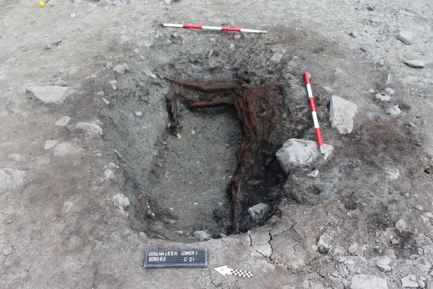
When the burnt mound was excavated, several subsoil-cut features including three wood-lined troughs, a large pit containing a composite stone and timber bench feature, and several other pits and post-holes were revealed beneath it. A structure delineated by eight post-holes, a pit, a stake-hole, and an internal post-hole indicating a possible roof support, as well as associated features including six pits, a post-hole and two stake-holes, were also revealed beneath the mound. In addition, a small burnt spread and an isolated pit were revealed to the east and south-east of the burnt mound respectively.
The burnt mound at Coolnaleen Lower 1 is a Recorded Monument (KE010-077), classified as ‘Fulacht Fiadh, site possible’. Also located at the site was a stone-built well, also a Recorded Monument (KE010-079), classified as a ‘Holy well’. The well is not marked on the first-edition six-inch OS map (1846) but is clearly visible on the first-edition 25-inch OS map (1896−97). Considering the cartographic evidence, current local knowledge and excavation evidence, it is clear that the well at Coolnaleen Lower 1 is a post-medieval feature.
Artefacts recovered from archaeological features related to the burnt mound activity consist of a sandstone flake, two flint flakes and a shale axehead. Artefacts recovered from post-medieval activity at the site comprise four sherds of white glazed pottery and a cream glazed ink bottle.
In the absence of absolute dating, given the nature of the site type, it would not be unreasonable to suggest a Bronze Age date for the archaeology at Coolnaleen Lower 1.
Post-excavation analysis is ongoing and it is hoped that specialist reports, including radiocarbon dating and comparative research, will further enhance our understanding of the site.