2019:636 - FÁN (FAHAN): Dunbeg (An Dún Beag) Promontory Fort, Kerry
County: Kerry
Site name: FÁN (FAHAN): Dunbeg (An Dún Beag) Promontory Fort
Sites and Monuments Record No.: KE052-270001
Licence number: E005005
Author: Laurence Dunne
Author/Organisation Address: 3 Lios Na Lohart, Ballyvelly, Tralee, Co. Kerry
Site type: Promontory fort - coastal
Period/Dating: Early Medieval (AD 400-AD 1099)
ITM: E 435008m, N 597368m
Latitude, Longitude (decimal degrees): 52.103579, -10.408568
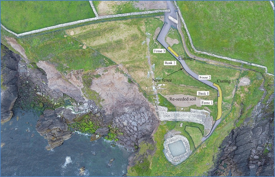
Archaeological works undertaken at Dunbeg Promontory Fort in May 2019 consisting of archaeological monitoring and targeted excavations were associated with construction of a new safety fence and a pathway to facilitate safe public access to the eastern limits of the site. In all a total of 42 hand-excavated post-holes for the fence were archaeologically monitored. The post-holes had an average diameter of 0.4m and a maximum depth of 0.5m. No archaeological deposits, features or artefacts were found during monitoring.
Two cuttings (Cutting 1 and Cutting 2) were excavated along the footprint of the new pathway in areas that had not been touched by Professor Terry Barry’s excavations in 1977. In the interests of continuity, this report has followed the morphological captions used by Barry i.e. Fosse 1, Bank 1 etc. Both cuttings were entirely excavated by hand. Excavated material was spread, raked, metal-detected and partially sieved in designated areas on site. The good quality spoil, the majority of which comprised in-wash sandy alluvium, was re-spread and re-seeded by OPW personnel in areas that had been impacted by the erosion in November 2017.
Cutting 1 measured 15m x 2m (max. width), was curvilinear in shape and oriented generally north-south extending from Fosse 2 via a gap in Bank 1 and across Fosse 1. Removal of the topsoil and cleaning through the existing gap in Bank 1 revealed that a small section of the basal remains had survived. The in-situ remains of Bank 1 comprised of compacted orange-coloured silty clay material, with frequent small stones. No charcoal or any organic material was noted in the fill. Fosse 1 recorded in Cutting 1 is a U-shaped ditch, 6.2m in width and a maximum excavated depth of 1.95m. Twenty-six deposits were recorded in Fosse 1. The northernmost limit of Cutting 1 was excavated to establish the morphological relationship of Fosse 2 with Bank 1. Excavation revealed that the natural level, comprising yellow silty clay, was reached at a depth of 1.1m. Ten fills were recorded in Fosse 2.
The linear Cutting 2 measured 6.5m x 1.2m and was opened across Fosse 3. Natural yellowish-orange subsoil was reached at a depth of 0.6m. Beneath the sod layer a modern deposit was exposed that comprised of gravel and modern fragments of glass, pottery and bits of plastic. Cutting 2 was archaeologically featureless and devoid of any artefacts.
Reference
Barry T. B. 1981. ‘Archaeological Excavations at Dunbeg Promontory Fort, County Kerry, 1977’ Proceedings of the Royal Irish Academy 81C, 295-329.