2019:575 - NEWFORD, Athenry, Galway
County: Galway
Site name: NEWFORD, Athenry
Sites and Monuments Record No.: GA084-101
Licence number: 18E0713
Author: Declan Moore
Author/Organisation Address: 3 Gort na Rí, Athenry, Co. Galway
Site type: Historic town
Period/Dating: Multi-period
ITM: E 549721m, N 727203m
Latitude, Longitude (decimal degrees): 53.292743, -8.754151
Monitoring took place of a greenfield site at Newford, Athenry, Co. Galway. The development site was subject to a geophysical survey and testing by Margaret Gowen & Co. Ltd. in June 2006. The 2006 report identified one geophysical anomaly near the site of a cist (GA084-101–); this was later tested and was deemed to be non-archaeological. Earlier testing in the southern half of the field revealed 10 features, primarily pits of varying size or spreads of blackened clay. Three of these were sectioned and produced no artefactual evidence.
The site was subsequently assessed by Magnus Archaeology in February 2017. A geophysical survey of the site was recommended. The 2017 gradiometer survey (17R0072) was dominated by ploughing trends. The southern half of the gradiometer data set was dominated by broad modern responses, suggesting significant ground disturbance had occurred here. The resistance survey identified clear high resistance responses in the area where the cist was located.
Monitoring of topsoil stripping commenced on 4 December 2018 and continued throughout December 2018 and into January 2019.
In general the stratigraphy throughout the site consisted of topsoil and sod overlying a mid-brown sandy silty subsoil. At the northern end of the site the subsoil varied, ranging from an orangey-brown sandy silty clay to a whitish-grey compact clay at the north-east. An archaeological site which comprised of a series of pits and post-holes of unknown purpose was identified. Excavation was undertaken in January 2019.
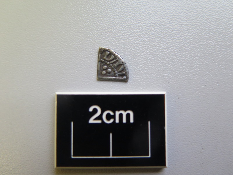
Excavation work concentrated on an area 20m north-south by 15m, which exposed a possible kiln and pit and spread features. In total 9 possible pit or post features were identified. The majority of the pits contained silty clay deposits with occasional charcoal flecks and patches of heat-affected clay. The investigation of the pits over a two-week period resulted in the recovery of a silver coin from the upper fill of one of them. This coin, a Henry III type II penny by the moneyer Davi, was minted between 1251 and 1254. The coin may have passed through the hands of the Anglo-Norman traders in the fledgling market town of Athenry. In the mid-13th century the town was under the feudal lordship of Meiler de Bermingham, a lieutenant of Richard de Burgo, 2nd Earl of Ulster and 3rd Baron of Connaught. Beyond the secure fortifications of the town defences much of the surrounding land was controlled by a hostile native population led by the powerful O’Connors, kings of Connacht. The precariousness of this Norman outpost is evidenced in the Annals which record two significant attacks on the town in 1249 and 1316. The date on the coin corresponds with these turbulent times.
The features exposed at Newford represent the remains of 13th-century activity of an unknown purpose. No diagnostic material was recovered. Wet sieving of samples did not result in any usable charcoal or environmental remains to elucidate the purpose of the features.
The activity can, however, be dated to sometime after 1241 which is roughly contemporaneous with the earliest buildings at Athenry. According to the Irish Walled Towns Network ‘The earliest remaining building in the town is the Castle, built at the ford by Meiler de Bermingham, probably shortly before 1240. This castle, one of the finest 13th-century castles remaining in Ireland, now consists of a three-storied keep surrounded by a strong curtain-wall which had two corner-towers and a corner-buttress near the strongly fortified gate. Meiler de Bermingham also caused the Dominican Priory of SS. Peter and Paul to be erected in Athenry. The Priory was started in 1241 and finished in 1261’.
The site occupied a low south-east to north-west aligned ridge located to the west of Athenry town and would have afforded good views in all directions. This ridge line may have marked the western approach to the early town and is located south-west of the Lorro Gate. The site was located on a relatively level platform of compacted clay with the ground sloping gradually to the south and north. The site may have served some purpose in the founding construction of Athenry town.