2019:784 - DUBLIN 1: No. 133 Capel Street, Dublin
County: Dublin
Site name: DUBLIN 1: No. 133 Capel Street
Sites and Monuments Record No.: DU018-020151, DU018-020048
Licence number: 17E0196
Author: Yolande O'Brien, Courtney Deery Heritage Consultancy Ltd.
Author/Organisation Address: Lynwood House, Ballinteer Road, Dublin 16, D16 H9V6
Site type: Religious house - Cistercian monks
Period/Dating: Medieval (AD 400-AD 1600)
ITM: E 715210m, N 734475m
Latitude, Longitude (decimal degrees): 53.347935, -6.269636
Two phases of test excavations were undertaken by Linzi Simpson for Courtney Deery Heritage Consultancy Ltd. on behalf of Cathedral Leisure Limited at the former Boland’s Bakery at a large site to the rear of Capel Street, Meeting House Lane, Little Mary Street and Arran Street East. The site ranges across what was formerly the precinct of the medieval abbey of St Mary. The first phase of testing informed an initial impact assessment, while the second phase was in response to a Further Information Request (FIR) for Planning Application Ref: 3572/18, Decision Order No. P3916.
The development site consists of a number of historic buildings to the rear (west) of Capel Street, the earliest of which is a Meeting House dated to between 1697 and 1703, which is a Recorded Monument (DU018-020151). The development also contains other industrial heritage buildings related to the large 19th-century Boland’s Bakery. These will be incorporated into the new development which is to be a hotel.
The historical sources indicate that the site lies within the immediate environs of St Mary’s Abbey. Cistercian abbeys were usually built to a common plan which would include the church in the northern range, normally flanked by the Chapter House on the east, with the domestic buildings and the refectory (dining house) to the south and additional domestic buildings to the west. The Chapter House survives as a cellar just south of the site under discussion, on the eastern side of Meeting House Lane. This survival anchors the position of the quadrangle to the middle of Meeting House Lane with the cloisters and garth located directly west of the Chapter House (in what is now the lane).
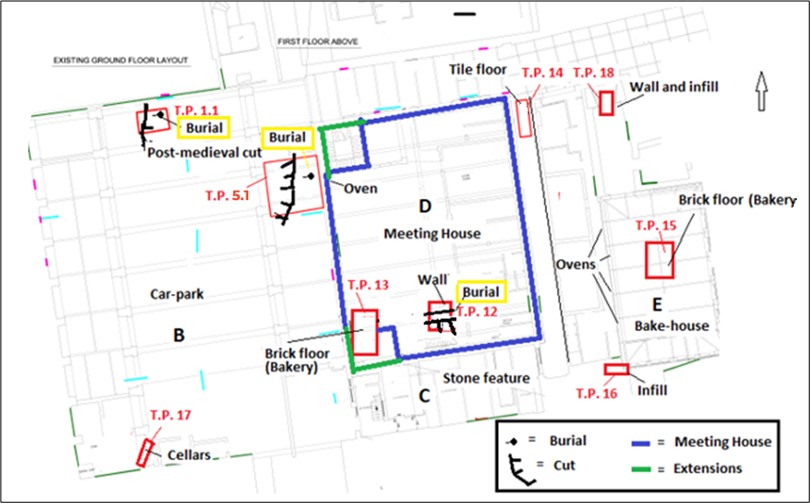
Phase 1: Testing in this phase comprised of 11 trenches which were excavated by hand and with the aid of a mini-digger in the carpark building (B) and the passageway (F) over the weekend of 27 January 2018.
The testing established that the ground in the car-park (B) was made up of deep post-medieval infill deposits of clays and rubble, which were found to be up to 3.1m in depth in places. There were back-filled brick cellars over most of the western side of the car-park (B), which must be related to red-brick domestic 18th-century houses shown on the 1756 map by Rocque. The northern and eastern sides of the car-park building (B), however, produced evidence of banded post-medieval infill clays extending from the car-park over to the west wall of the Meeting House. Thus, this area was evidently a yard or garden area and consequently had no cellars. No evidence of medieval clays was found during this testing phase, but both the rubble and the clays deposits contained numerous human bones, presumably originating from the cemetery attached to the monastery.
The excavation in the passageway (F) was very limited in depth but infill deposits were found in this location also, similar to those found in Building B. Human bones were also found suggesting a deliberate spreading of disarticulated human remains over a large area.
The testing included stripping sections of the various walls to reveal the masonry type. No standing medieval remains were identified as part of this process. The Meeting House was found to be of substantial limestone build, with occasional early brick (1708) but, significantly, the northern and western wall foundations may have been founded on earlier walls. While this may well have represented part of the Meeting House wall foundations, it may also indicate the presence of an earlier abbey building or wall.
Phase 2: This phase of testing was undertaken in February and March 2019 and involved the excavation of seven trenches throughout the buildings. The investigations located in situ burials cut into boulder clay in three different locations, against the northern wall of the car-park (B), against the outer western face of the Meeting House and within the Meeting house (D) itself at the southern end. These burials are related to the earliest internments in the graveyard of St Mary’s abbey, as confirmed by two carbon-14 dates dating to the abbey period. SK1 (Test-trench F5.1, context 8) dated to between cal AD 1165-1265 (2 sigma) while SK4 (Trench 12, context 27) was possibly earlier than the abbey dating to between cal AD 1025-1160 (2 sigma). Loose human bone in the rubble, in Phase 1, returned a date of between 1298–1416 cal AD (2 sigma).
The dating of the burials suggest that the cemetery of the abbey was located in the northern end of this urban block. This, in turn, indicates that the church of the abbey is likely to be further south, outside the line of the development. The testing in the Car-park (B) confirmed the presence of layers of infill deposits from the 17th century onwards at the northern end of the site but also located a large 19th-century cut that had removed most of the deposits in this area. At the southern end of the building, a test-pit against the southern wall exposed a brick cellar, confirming the presence of brick houses along the western side of the car-park and identifiable on Rocque’s map of Dublin in 1756. This confirmed this southern wall was not medieval in date and therefore not related to the abbey church.
The investigations within the Meeting House found structural evidence of both the Meeting House phase and the Bakery. The stripping of the Meeting House walls revealed a myriad of features within the walls which had been covered up in its last usage. It was established that the Meeting House was T-shaped, a rare survival and early form, which can be compared with a few other early Meeting Houses in Ireland and Scotland. The building was then converted into a rectangular build by adding extensions on the western side, at the northern and southern end. As the Meeting House is shown as square in Rocque’s map of 1756, this would suggest the extensions were carried out before this time.