2019:755 - MILLTOWN (1), Grange Castle West, Dublin
County: Dublin
Site name: MILLTOWN (1), Grange Castle West
Sites and Monuments Record No.: N/A
Licence number: 19E0680
Author: David Bayley & Tim Coughlan, c/o IAC Ltd.
Author/Organisation Address: Unit G1 Network Enterprise Park, Kilcoole, Co. Wicklow
Site type: Enclosure
Period/Dating: Early Medieval (AD 400-AD 1099)
ITM: E 700943m, N 731658m
Latitude, Longitude (decimal degrees): 53.325542, -6.484725
The following are the preliminary results of an archaeological excavation at Milltown 1, Grange Castle West, Dublin 22, located at the site of the proposed Grange Castle West Business Park Access Road development.
The site comprised of three cuttings, designated Areas 1-3.
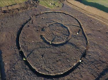
The main area of activity was Area 1. The earliest feature in Area 1 was a shallow linear trench that was oriented east-west. It was cut by two concentric ditches. The outer ditch was sub-circular in plan and enclosed an area measuring 28.6m (east-west) x c. 32m. The cut of the ditch was V-shaped and was generally cut through natural bedrock. It varied between 1.1m and 1.63m deep with the width generally varying between 1.6m and 1.8m. There was no obvious entrance in the ditch. However, it was notably at one point in the east-north-east, where it was only 0.3m deep for a length of c. 3m. It is possible that there was a formal entrance at this location prior to the ditch being subjected to a re-cut. The re-cut was generally between 0.3m and 0.4m in depth and was present along the entire length of the ditch.
The inner ditch enclosed an area measuring c. 11m in diameter. The ditch cut varied in width from 1.4m, with a maximum depth of 0.36m. This depth was very similar to the re-cut of the outer ditch, which could suggest contemporaneity between the inner ditch and the re-cut. The ditch was cut into natural bedrock. There was an entrance in the west-south-west that was 1.8–2m wide. No features of archaeological significance were identified in area enclosed by the inner ditch. The area between the two ditches contained a number of furnaces, kilns, pits, post-holes and spreads that all appear to be related to metalworking. Two spreads were also recorded external to the outer ditch. All of this activity is currently interpreted as dating to the early medieval period.
In Area 3, an isolated pit was the only feature identified. It was filled with heat-shattered stone, similar to that found in burnt mound/fulacht fiadh-type sites.
No features of archaeological significance were identified in Area 2. Areas of burning in the cutting were shown to be related to root burning and are probably related to modern field clearance/agricultural activity.
This preliminary site interpretation has been based on stratigraphic relationships and typological similarities between features that were identified during the excavation works. It is hoped that ongoing post-excavation works and AMS dates will add to our understanding and interpretation of the site.

