2019:744 - DUBLIN 2: 41-46 South Great George’s Street & 51-53 Lower Stephen Street, Dublin
County: Dublin
Site name: DUBLIN 2: 41-46 South Great George’s Street & 51-53 Lower Stephen Street
Sites and Monuments Record No.: DU018-020
Licence number: 18E0661 ext.
Author: Paul Duffy, c/o IAC Ltd.
Author/Organisation Address: Unit G1 Network Enterprise Park, Kilcoole, Co. Wicklow
Site type: Historic town
Period/Dating: Multi-period
ITM: E 715544m, N 733777m
Latitude, Longitude (decimal degrees): 53.341592, -6.264877
Archaeological excavations were undertaken at 41–46 South Great George’s Street and 51–53 Lower Stephen Street. Excavations commenced on site on 22 April 2019 and were completed by 10 October 2019. Excavations followed on from an earlier programme of testing undertaken under the same licence.
The development area is located within the Zone of Archaeological Potential for Dublin City (DU018-020), but is situated outside (c. 175m south-east of) the medieval walled town. The site is situated to the immediate north of ecclesiastical enclosure DU018-020389, with St. Peter’s Church and graveyard (DU018-020089, 378) and the St. Stephen’s Leper Hospital and Church (DU018-020063, 020593), located to the south.
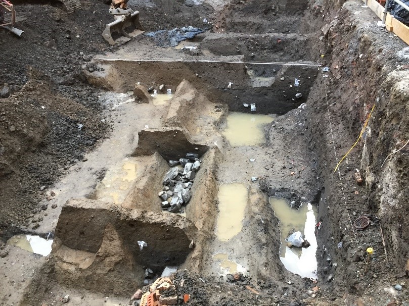
The excavations have revealed boundary ditches along the southern edge of the site dating to the 11/12th century; these substantial ditches were maintained and slightly amended over the course of several centuries. It is likely that the earliest phase of these ditches paralleled a small ravine/inlet that emptied into the tidal pool known as the Dubh Linn and corresponds to pre-Norman defences identified to the west of George’s Street (Simpson 2006). For a brief time in the later medieval period (c. 1500), the majority of these ditches were backfilled and a structure built upon a foundation of driven stakes was erected. Soon after, this structure was cut away by a later ditch re-establishing the alignment of the earlier boundary. This boundary remained open into the 17th century.
Two large pits from this broad timeframe may indicate that plots were established on the site, running southwards from a street front somewhere to the north, possibly to Fade Street, though this is not supported by the cartographic evidence. Alternatively, these pits could represent the beginning of a tanning enterprise in the 14th to 15th century, on what was marginal ground outside of the city walls. Evidence for the continuation of this tanning activity from the 16th through to the 18th century was identified in the central area of the site. Environmental analysis has shown that the area retained a marginal character until the later 17th century.
The extensive urbanisation that George’s Street underwent from the later 17th century was not captured onsite in the archaeological record. Some very fragmentary walls and drains along the southern façade of the site may date to this period, though no cellars of Georgian date or earlier were encountered. These may well have once existed along the George’s Street façade but would have been removed by the construction of an extensive Victorian cellar.
The extensive redevelopment of the site in the late 19th century heavily truncated much of the archaeology and the resulting Victorian architecture dominated the site until the current development. The façade of the 1880s building has been retained along George’s Street and forms part of the final development.
All post-excavation works and specialist analyses have now been completed.
Reference
Simpson, L. 2006 ‘John Rocque’s map of Dublin (1756): a modern source for medieval property-boundaries.’ In S. Duffy (ed.) Medieval Dublin VII, Dublin: Four Courts Press.