2019:627 - PORTMARNOCK & MAYNETOWN, Dublin
County: Dublin
Site name: PORTMARNOCK & MAYNETOWN
Sites and Monuments Record No.: DU015-014
Licence number: 18E0016 ext
Author: Gill McLoughlin, C/O Courtney Deery Heritage Consultancy
Author/Organisation Address: Lynwood House, Ballinteer Road, Dublin 16
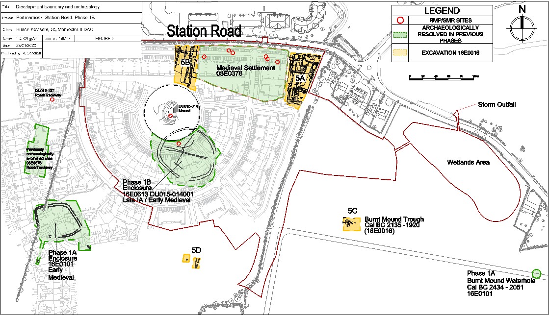
Site type: Mound
Period/Dating: Medieval (AD 400-AD 1600)
ITM: E 723355m, N 742445m
Latitude, Longitude (decimal degrees): 53.417687, -6.144261
Archaeological monitoring was carried out in late 2018 and into 2019 under an extension to the original licence (see 2018:314) in relation to landscaping works to upstanding mound DU015-014 and foreshore storm outfall works. The monitoring was carried out as part of Phase 1B of a residential development.
The mound was preserved in situ within a green space in the development, incorporating play, seating and signage areas. This involved a programme of works by SAP landscape contractors. Since a 20m buffer zone fence around the mound was erected in 2012, the mound had become overgrown with dense bramble and the surrounding area had been populated with self-seeded trees. Monitoring of all works at the mound and its 20m buffer zone were carried out to ensure that landscaping works would not have a negative impact on the mound.
The process involved initial cutting of access routes through the bramble to facilitate spraying of the vegetation with herbicide, followed by cutting and removal of all vegetation once the herbicide had taken effect. A low weight-bearing grass-cutting machine was used on the area surrounding the mound and on the mound itself vegetation was cut and removed by hand. Roots were not removed, and the existing ground surface was not reduced. The area surrounding the mound was covered in a thin layer of soil (c.100mm) to fill existing hollows etc. and the entire area was then covered with a geotextile layer. A layer of soil c.300-400mm deep was then spread over the entire area, respecting the existing topography of the mound and seeded. All structures in the area (play, seating and signage) were founded in the protective topsoil layer, without penetrating the geotextile layer.
In the field to the east of the Phase 1B housing area, a wetlands area, storm outfall and associated pipelines comprised part of the Portmarnock Phase 1B development. Monitoring of construction works for the storm outfall was carried out under an extension to the licence in September-October 2018. The overall area of disturbance within the estuary was approximately 10m x 6m and involved the installation of a 525mm diameter concrete outfall pipe to a distance of 3m beyond the high-water mark and associated concrete base, headwall and wing walls.
The works involved the removal of a 6m section of limestone wall which was exposed, cleaned and photographed before being removed under archaeological supervision. The wall measured 0.5m wide and had a maximum depth of 2.2m. It comprised roughly-hewn limestone blocks faced on both sides with rubble fill inbetween, and patched concrete repairs in places. Remains of this wall continued beyond the works area parallel to the road to the south-east, but it was not as substantial as elsewhere and was obscured by dense vegetation. No additional features of interest were identified as a result of these works.