2019:625 - DUBLIN 8: TUD, Kevin Street Lower, Dublin
County: Dublin
Site name: DUBLIN 8: TUD, Kevin Street Lower
Sites and Monuments Record No.: DU018-020 & DU018-020195
Licence number: 19E0554
Author: Kim Rice, AMS–CRDS
Author/Organisation Address: AMS–CRDS, c/o 2 Grosvenor Terrace, Monkstown, Blackrock, County Dublin, A94 Y209
Site type: Historic town
Period/Dating: Multi-period
ITM: E 715432m, N 733266m
Latitude, Longitude (decimal degrees): 53.337026, -6.266744
Archaeological testing was carried out within the TUD campus, Kevin Street Lower, Dublin 8. The site, which encompasses an area of 1.44ha, is bounded by Kevin Street Lower to the north, New Bride Street to the west and Camden Row to the south. Church Lane transects the north-eastern section of the site, while Liberty Lane delimits its north-eastern edge. Kevin Street Library abuts the north-eastern part of the site, while St Kevin’s Park abuts its south-eastern edge.
The site occurs within the Zone of Archaeological Protection for Dublin City (DU018-020) and the posited site of a medieval house (DU018-020195) is located in its north-west corner. St Kevin’s Church and graveyard (DU018-020078) lie outside the proposed development area to the south-east.
Seven test trenches were opened in four different areas to investigate the extent, date and significance of archaeological remains onsite, to establish the extent of late nineteenth-century and twentieth-century disturbance, and to assess the depth of the natural subsoil throughout the site.
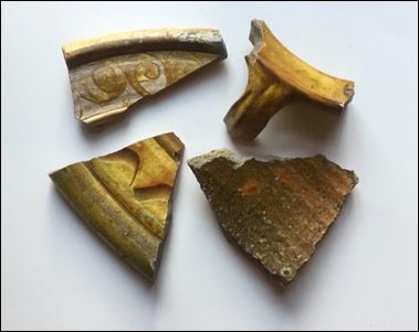
The testing demonstrated the presence of stratified archaeological deposits throughout the investigated areas. Trenches 1, 2 and 3 in the northern car park uncovered the foundations of an eighteenth-century structure, in addition to two nineteenth-century walls. The eighteenth-century wall in Trench 1, which occurred in association with glass, tiles and ceramics, possibly correlates with one of the structures shown fronting onto Kevin Street on Rocque’s map of 1756. The two nineteenth-century walls may represent the remains of structures shown on the Ordnance Survey town plans from the period. Demonstrable evidence for medieval activity was identified in Trench 1. No medieval artefacts were recovered from Trenches 2 or 3; however, they included deep stratified deposits that may derive from the period.
No evidence for medieval activity was noted in Trenches 4 or 5 in the southern car park, which both produced late nineteenth-century remains. These included a former floor surface that was composed of red brick, while a loose extensive backfill deposit was located to the north of it. These remains are probably associated with the former ‘Steam Saw Mills’ that is shown on the revised Ordnance Survey map series from 1890–1. The compaction, extent and character of the associated deep deposits indicate it may represent the backfill of a cellar that formed part of the late nineteenth-century saw mill.
Trenches 6 and 7 were primarily investigated to ascertain if the graveyard associated with St Kevin’s Church extended beyond the eighteenth-century boundary wall to the north and north-east. No human remains were identified in either trench, which also did not include any evidence for structures or cut features. However, deep stratified deposits were noted in both trenches that produced post-medieval artefacts. An anaerobic clay was also identified at a depth of 1.3m below ground level. The character and depth of the deposit suggests it probably dates to the medieval period.