2019:367 - DUBLIN: 31–34 Upper Abbey Street and 42–51 Great Strand Street, Dublin
County: Dublin
Site name: DUBLIN: 31–34 Upper Abbey Street and 42–51 Great Strand Street
Sites and Monuments Record No.: DU018-115
Licence number: 19E0110
Author: Caitríona Moore, Archaeology and Built Heritage
Author/Organisation Address: Spade Enterprise Centre, St. Paul's Smithfield, Dublin 7
Site type: Historic town
Period/Dating: Multi-period
ITM: E 715559m, N 734418m
Latitude, Longitude (decimal degrees): 53.347347, -6.264418
The site lies within the zone of archaeological potential for the historic city of Dublin (DU018-020) and is adjacent to DU018-115, a medieval timber revetment excavated in 2002 on a neighbouring development site to the south-west (Walsh 2005).
The excavation revealed the continuation of the medieval revetment (DU018-115) in the south-western area of the site. It entered from the adjacent site and a short section was recorded before it ran beneath a bank which could not be removed for health and safety reasons. This section of the revetment was orientated east-north-east/west-south-west and comprised transverse braces in which were set longitudinal baseplates. Vertical posts set into the baseplates supported horizontal, longitudinal planks set edge to edge. No further traces of the revetment were found along its projected line to the east-north-east. In the central part of the site c. 20m to the north, fragmentary remains of two parallel timber revetments and a wattle fence were uncovered. These were also orientated east-north-east/west-south-west. These features continued into the north-eastern area of the site where they were very well preserved. Here the timber revetment was of identical design to that recorded in the south-western part of the site. Also in this area were several fragmentary timber and wattle structures, all orientated east-north-east/west-south-west, most likely remains of additional revetments. Associated with these at the very north-eastern limits of the excavation was a stone structure which extended into the adjacent site where it was excavated under licence 19E0293.
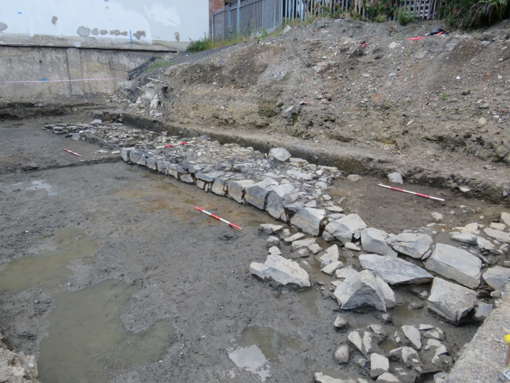
Running east-north-east/west-south-west across the central part of the site were the foundations of a substantial stone wall 2m in width x c. 10-800mm in surviving height (0.27m to -0.59m OD). It was of dry stone construction and where best preserved comprised a basal layer of flat limestone blocks, the outermost of which were substantial and roughly faced. Overlying this was a rubble core of small to medium sized pieces of angular limestone. The wall closely followed the line of the outer precinct of St. Mary’s Abbey (DU018-2048) as depicted on Speed’s map of c. 1610, and is believed to be the remains of that structure. All of the medieval features on the site were covered with riverine deposits over which was a deep post-medieval reclamation layer.
Post-medieval remains were extensive and included the foundations of houses on Abbey Street and Great Strand Street, the former built on a raft of reused structural timbers. Features in the back plots included wells, cess pits, latrines and a small tannery. Foundations of small buildings fronted onto both sides of Byrne’s Lane, a cobbled surface of which ran across the width of site.
The recovered artefact assemblage included large amounts of ceramic, glass and leather along with objects of wood, bone, antler and metal. Rare finds included wax seals, porcelain ointment jars and decorated copper alloy mounts. Recovered in tandem with the artefacts were samples of animal bone, soil, plant remains, wood and mortar. Post-excavation analysis is ongoing at the time of writing.
Reference:
Walsh, C. 2005. ‘Archaeological excavation of the Anglo-Norman waterfront at Strand Street Great, Dublin’, in S. Duffy (ed.) Medieval Dublin VI, Dublin, 160-87.