2019:322 - HARCOURT SQUARE, Harcourt Street & Charlotte Way, Dublin
County: Dublin
Site name: HARCOURT SQUARE, Harcourt Street & Charlotte Way
Sites and Monuments Record No.: N/A
Licence number: 19E0118
Author: Gill McLoughlin, Courtney Deery Heritage Consultancy
Author/Organisation Address: Lynwood House, Ballinteer Road, Dublin 16
Site type: No archaeology found
Period/Dating: N/A
ITM: E 715639m, N 732960m
Latitude, Longitude (decimal degrees): 53.334233, -6.263749
Monitoring of ground investigation works was carried out at the Garda Headquarters at Harcourt Square, Harcourt Street and Charlotte Way, Dublin 2 in response to a condition of planning (Dublin City Council, Ref. 3024/18, Condition 17) on behalf of Hibernia Reit. The monitoring forms part of the archaeological impact assessment for the proposed development.
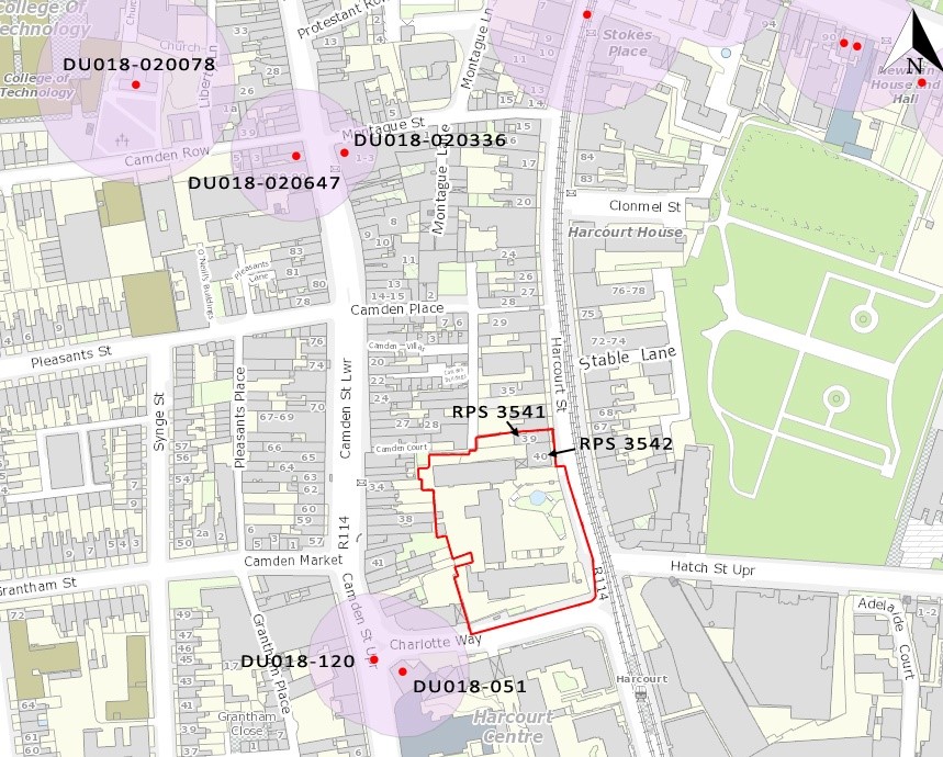
The proposed development site is located outside of the Zone of Archaeological potential for the historic town of Dublin (DU018-020). The closest RMP sites are an inn (DU018-051, the present-day location of the Bleeding Horse Pub) and a building (DU018-120), located c. 40-50m to the south-west. The protected structures at No. 39 and No. 40 Harcourt Street (RPS Refs: 3541, 3542) form part of the development site to the north.
There is no recorded evidence of prehistoric activity within the development site or its surrounds. The study area in early medieval, pre-Viking, pre-Norman and medieval times is not well documented and in the mid-18th century the site was still on the periphery of the developed area of the city, comprising open fields and cultivated plots. Cartographic sources show that Harcourt Street was laid out in 1777 and by 1843 it contained 72 houses. The protected structures at No. 39 and No. 40 Harcourt Street appear as the two southernmost structures at the end of a terraced row. John Hatch, a graduate of Trinity College Dublin and a barrister, built the largest and widest house in the street at No. 40 Harcourt Street for himself and he died there in 1797. At this time and up until the 1960s a garden occupied most of the overall development site.
A number of archaeological investigations comprising testing and monitoring have taken place in the vicinity of the overall development site, however nothing of archaeological significance has been identified as a result of any of these investigations. No stray finds are recorded in the topographical files of the National Museum of Ireland in the vicinity of the proposed development site. With the exception of No. 39 Harcourt Street, the site and the rear of No. 40 were developed in their entirety in the 1960s.
Site investigation (SI) works were carried out by Causeway Geotech in advance of development of a detailed design. The works comprised 22 boreholes and nine machine-dug foundation inspection pits. These works were archaeologically monitored. The site investigation works suggest that during the development of the site in the 1960s the site was reduced to the sterile fill/natural clay and was covered in a thick, reinforced concrete slab. The reinforced slab across the entirety of the site measures at least 0.4-0.8m thick (with an outlier of 1.4m). The results revealed a very stiff brown slightly sandy gravelly silty clay with low cobble content to a firm mid-brown clay with infrequent stone inclusions. Beneath this was a grey-black boulder clay. There were no archaeological features or archaeologically-enriched soils revealed during the SI works, the soils were sterile and contained no man-made inclusions.
Prior to the 1960s the site was an enclosed garden associated with No 40 Harcourt Street, a late 18th -entury house (which was incorporated into the 1960’s build) The 1960’s building comprises a basement structure (covered and open), the existing ground within the site is at least 2.5m below the Harcourt Street and Charlotte Way street levels. Its construction removed to boulder clay all evidence of previous activity of the site. This is confirmed by the site investigation works which indicated that the site was initially cleared to subsoil level across the site and then laid with a thick reinforced concrete slab.

