2019:252 - BALLYMAKAILY, Dublin
County: Dublin
Site name: BALLYMAKAILY
Sites and Monuments Record No.: N/A
Licence number: 19E0038
Author: Ger Dowling, AMS Consultancy
Author/Organisation Address: Unit 1, Hector Street Mills, Kilrush, Co. Clare
Site type: Enclosure and Habitation site
Period/Dating: Multi-period
ITM: E 702480m, N 731800m
Latitude, Longitude (decimal degrees): 53.326522, -6.461616
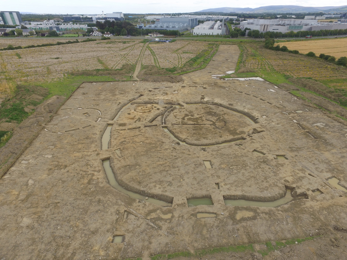
Archaeological excavations were undertaken by Archaeological Management Solutions in collaboration with Cultural Resource Development Services at Ballymakaily townland, Grange Park Business Park, Co. Dublin, over a 16-week period, from May to August 2019. The excavation was conducted in advance of proposed industrial development and followed on from geophysical survey and test investigations at the site in early 2019. This work revealed the buried remains of a significant archaeological complex that was thought to comprise a long-running ditch suggested to form part of an ancient field system (Area 1); a small spread of burnt stones of potential prehistoric date (Area 2); and a large, circular enclosure, possibly defined by two, widely-spaced concentric ditches (Area 3).
Full excavation of these areas revealed an impressive array of features associated with multi-phase settlement and agricultural activity, possibly extending from prehistoric to modern times. The principal remains were identified in Area 3 and comprised two successive phases of enclosure. Potentially the earliest was a large, roughly circular enclosure seemingly defined by two widely-spaced ditches, set c.15–20m apart. It had an overall (north–south) diameter of about 70m, with the inner boundary reaching a maximum diameter of c.30m. The area between the enclosing elements was traversed by a number of possible radial ditches that may delineate the footprint of several small fields or paddocks. This phase of enclosure appears to have been followed by the construction at the same location of a large, sub-circular ditched enclosure, with maximum overall dimensions of 50m north–south by 52m. It overlapped with the Phase 1 inner enclosure ditch on the south and east, and the Phase 1 outer enclosure ditch on the north and west, thereby erasing all trace of the earlier cuts and deposits. Both phases of enclosures produced evidence for internal occupation in the form of several possible circular structures/buildings, as well as pits, post-holes, spreads, etc., while their defining ditches were likely originally accompanied by internal earthen banks. The enclosures are probably early medieval raths, though this interpretation is tentative pending the results of post-excavation analyses.
A number of possible ancillary features were identified immediately outside the main enclosures, on the north and north-west. This included a small sub-circular enclosure defined by ditch that measured approximately c.18m in diameter. The ditch, which splayed outwards on the north-east and produced tentative evidence to indicate the former presence of an external bank, was breached by three gaps on the north, north-west and south-east, one or more of which may represent an original entrance. A small pit containing a few fragments of burnt bone was the only feature discovered within the interior of the enclosure. A small, C-shaped ditch (length of chord c.16m) was also discovered a short distance to the north-east of the main enclosures and was found to contain three discrete deposits of charcoal-rich soil. These external features cannot readily be assigned to any particular phase in the site’s history and further work is required to determine their precise dating and significance.
The investigations did, however, produce limited evidence for potential pre-enclosure (prehistoric?) activity in Areas 2 and 3, where a series of pits containing charcoal-rich soil and burnt stone were identified. These features may be indicative of cooking and/or other related activities. An array of linear and curvilinear ditches and drains were also identified across the site and appear to be associated with post-enclosure (medieval/post-medieval) agricultural practices. The long-running linear ditch identified in Area 3 may likewise relate to post-medieval agriculture.