2019:138 - DISERT GRAVEYARD, Donegal
County: Donegal
Site name: DISERT GRAVEYARD
Sites and Monuments Record No.: DG084001
Licence number: 19E0150
Author: Fiona Beglane
Author/Organisation Address: CERIS Department of Environmental Science Institute of Technology, Sligo, Ash Lane, Sligo
Site type: Ecclesiastical site
Period/Dating: Medieval (AD 400-AD 1600)
ITM: E 587942m, N 887292m
Latitude, Longitude (decimal degrees): 54.733529, -8.187219
Disert, Co. Donegal DG084-001 is a multi-period archaeological landscape. Local tradition is that this was a Columban foundation and various cures and miracles are associated with the site. Disert lies directly under Carnaween Mountain, another pilgrimage site, which has deep folkloric traditions around Fionn MacCumhaill. As such Disert is of great archaeological and historical importance, and it continues to be culturally important, with a post-medieval pilgrimage that survives to this day.
The overall aim of the excavation research project is to investigate the nature and origin of the archaeological remains at Disert and to place them in their wider cultural and landscape context. 2019 was the first season of excavation and focused on key features previously identified through geophysics. While some geophysical anomalies proved to have geological rather than archaeological origins, evidence for activity was uncovered on the site ranging from the prehistoric period through to the nineteenth and twentieth centuries.
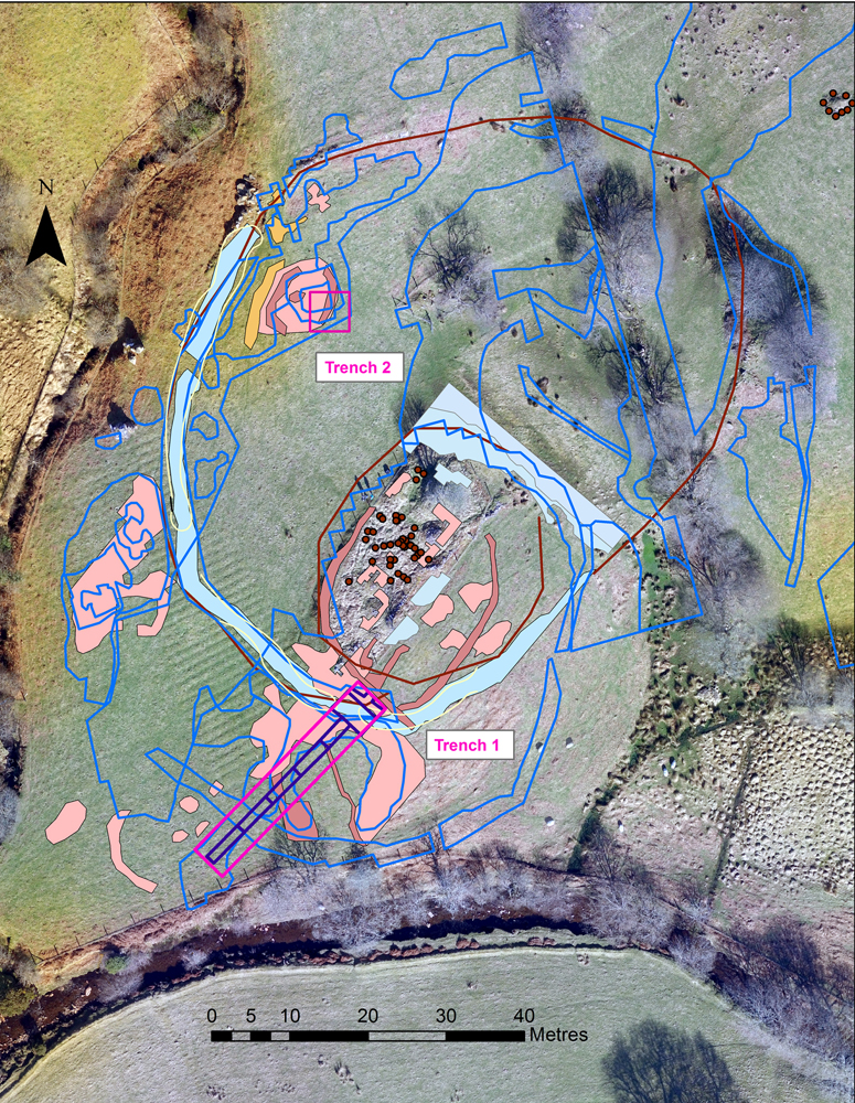
Much has been achieved in this first season of excavation. Two trenches were excavated. Trench 1 was divided into areas A to G, with areas A and B measuring c. 5m x 5m and areas C to G measuring 24.8m x 1.2m.
In Trench 1, a number of curvilinear geophysical anomalies in areas C, D, E, F and G have been shown to have geological rather than archaeological origins. There was no evidence of what the geophysics suggested may have been a potential ditch towards the south-western portion of the trench, nor was there evidence of a sub-circular enclosure in the central area, again suggested by geophysics. Two narrow linear anomalies running north-north-west/south-south-east across the location of the trench appear to reflect linear stone features found in the lazy bed ditches and so can be said to have been resolved.
In Areas A and B a more complex stratigraphy has been identified. Lazy bed banks and ditches overlie earlier features. The lazy beds run right up to the edge of the central enclosure DG084-001011, demonstrating that at one point the land was intensively farmed. Below these the most interesting features are a partly-excavated hearth and associated charcoal deposits. The presence of possible slag from the upper deposits elsewhere in the trench and of a lump of ferrous material directly overlying the hearth feature may point to evidence for metalworking on site. Further features have yet to be excavated in areas A and B, where the geophysics results suggest that the main enclosure ditch for the site continues.
In Trench 2, measuring 5m x 5m but excavated to natural across an area measuring 5m x 1.5m, the geophysics suggested the potential presence of a square-shaped stone building, however no evidence for this was recovered, and instead these anomalies appear to have again had a geological origin. The soil in Trench 2 was significantly deeper than in Trench 1 and there was no evidence for any lazy beds in this region, which lies inside the outer enclosure DG084-001001. Aerial photography supports this, showing that at the western side of the site the lazy beds do not extend far into the enclosure. This may indicate a desire on the part of earlier farmers to leave the main area of the site fallow, reflecting the importance of the graveyard and well to the community and the potential continued significance of the large outer enclosure DG084-001001 for gatherings associated with the turas.
Finds included nineteenth- and twentieth-century pottery and glass, clay pipe fragments, a pencil lead, possible tile fragments, a corroded ferrous object, a number of smoothed, rounded pebbles, prehistoric worked flints and a number of fragments of possibly-worked quartz. Soil samples, charcoal and animal bone were also recovered.