2019:696 - BANDON FLOOD RELIEF SCHEME, Cork
County: Cork
Site name: BANDON FLOOD RELIEF SCHEME
Sites and Monuments Record No.: CO110-019001-
Licence number: E4481 (C578)
Author: Judith Carroll, Judith Carroll and Company
Author/Organisation Address: Ballybrack Road, Glencullen, Dublin 18
Site type: Town
Period/Dating: Modern (AD 1750-AD 2000)
ITM: E 549121m, N 554979m
Latitude, Longitude (decimal degrees): 51.744837, -8.736790
The historic town of Bandon is listed as a Zone of Archaeological Potential (ZAP) delineated by the defensive walls built around it in the early 17th century (CO110-019-014). Works carried out in 2019 within the ZAP under Ministerial Consent C578, E4881. The license was granted for archaeological monitoring and excavation carried out for the Bandon Flood Relief Scheme.
The bulk of the work on the scheme was carried out between 2017–2018, though it had been commenced in 2016. In 2019, however, works in the ZAP continued on Séan Hales Place public amenity area on the north side of the river, to the east of Bandon Bridge, and with drainage north and south of the Bandon River. On the south side of the river, at Patrick’s Place, New Road and South Main Street, works mainly involved upgrading existing drainage in the town.
Sean Hales Place
Monitoring in the area had commenced in late 2018 in Séan Hales Place when cobbling and walls came to light. Works continued in early April 2019 when further cobbling and a further wall was identified. A main wall on the east side of the Séan Hales Place public amenity area was identified as an extension to the north bank of the parapet wall extending from Bandon Bridge. No finds or features predating the 18th/19th century were found apart from a musket ball which was unstratified.
Patrick’s Place, New Road
Work was carried out a on an existing drainage system in St. Patrick’s Place, New Road, Bandon on an existing culvert line on the west side of the roadway on the south-western end of the zone of archaeological potential, a short distance from the town wall on its southern side.
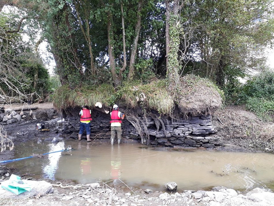
The culvert is of interest as it is very substantial and has features such as the sandstone and mortar upper levels and dry-stone lower courses which seem quite similar to the culverts on McSwiney Quay. It appeared to direct water in at least three openings, east, west and south. It may therefore be part of the drainage network of the town of the early 19th century and may relate to the management of water from the Bridewell River towards the Bandon River.
South Main Street/Bridge Lane
In January 2019, digging works recommenced in South Main Street/Bridge Lane to join a drainage trench to a manhole dug in the previous year. The remains of a stone wall cut through by pipe trenches was found. Directly to the east of this, along South Main Street, was a stone structure constructed of small, quite narrow limestone/sandstone slabs. This was identified as a culvert.
The top profile of the arc of the culvert was constructed of small, vertically placed, stones bound with mortar. Its construction is very similar to that of the footbridge culvert investigated during September 2016 on McSweeney Quay. Along with Patrick’s Place/New Road and the McSwiney Quay culverts, this feature may relate to a network of drains built in the early 19th century, possibly to manage flooding of the town.