2019:307 - BORRIS: Main Street, Carlow
County: Carlow
Site name: BORRIS: Main Street
Sites and Monuments Record No.: N/A
Licence number: 19E0612
Author: Marion Sutton & Seán Shanahan, Shanarc Archaeology Ltd
Author/Organisation Address: Unit 39A, Hebron Business Park, Hebron Road, Kilkenny
Site type: Tunnel
Period/Dating: Modern (AD 1750-AD 2000)
ITM: E 672521m, N 650612m
Latitude, Longitude (decimal degrees): 52.601925, -6.929419
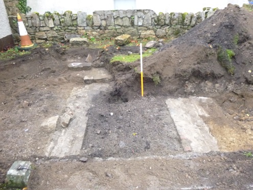
Six test trenches were machine excavated across the footprint of a proposed residential development site in Borris, Co. Carlow to assess the impact of site development on potential sub-surface archaeological remains, and in particular to determine the nature and extent of an underground stone and brick structure—a cell or passage-like structure—on the site. The structure is located in the front half of the proposed development site, extending westward from a point next to the boundary wall with Borris Garda Station. Test excavation was carried out on 1 November 2019.
The proposed development site is a long, thin, rectangular section on the north side of Main Street, Borris, positioned between the town’s Post Office to the west and the Garda Station to the east.
Test trenches measured 3–20m in length, 1.8m in width and 0.35–0.5m in depth. Soil stratigraphy generally comprised compacted gravel (yard surface) overlying c.0.35m of dark brown topsoil material, overlying yellow/brown sandy silt.
With the exception of an underground linear stone and brick structure, no additional features of archaeological or built heritage interest were exposed during test excavation at the site. There is currently no evidence of a direct physical link between the underground structure and Borris Garda Station on the adjoining property. However, it is probable that the structure is associated with the operation of the adjoining site when it functioned as a Constabulary Barracks in the 19th and early 20th century. A 1908 town plan of Borris records the existence of two small structures adjoining the west boundary of the Constabulary Barracks. That a structure adjoined the boundary is supported by the presence of concrete mortar that still covers part (1.98m) of the granite stone boundary wall.
The underground structure is comprised of a roughly square granite stone opening accessing a linear, brick-lined passage, measuring 1.35m wide internally. A notch in the west stone of the opening suggests it was accessed via a hinged door. The passage extends 3.3m westward of the opening, to a point beneath the concrete ramp at the base of the 20th-century shed/garage on the site.
Small quantities of finds were recovered from backfill in the underground cell/passage investigated in Test trench 5. The finds included slate fragments, an oyster shell fragment, a black glazed tile fragment, a clay tobacco pipe, and 19th-century pottery sherds.