2019:488 - NEWRY SOUTHERN RELIEF ROAD, Fathom Lower, Newry, Armagh
County: Armagh
Site name: NEWRY SOUTHERN RELIEF ROAD, Fathom Lower, Newry
Sites and Monuments Record No.: N/A
Licence number: AE/19/018
Author: David Kilner
Author/Organisation Address: AECOM The Studio, Cleaver House, 1-3 Donegall Square North, Belfast, BT1 5YE, UK
Site type: No archaeology found
Period/Dating: N/A
ITM: E 709156m, N 823813m
Latitude, Longitude (decimal degrees): 54.151703, -6.328967
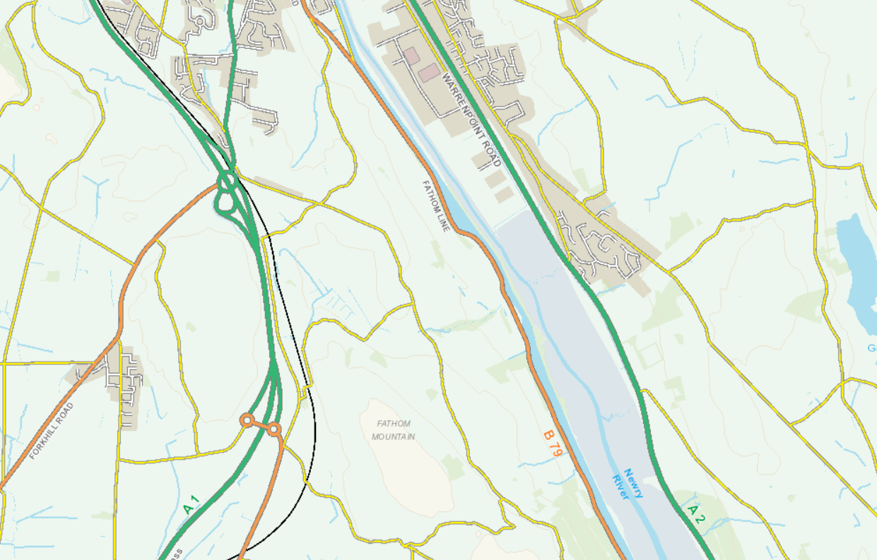
The licence related to the archaeological monitoring of trial pits excavated as part of Geotechnical Ground Investigation works associated with the planned Newry Southern Relief Road located on the southern outskirts of Newry City.
The relief road will provide a new strategic road connection between the A2 Warrenpoint Road (south of Newry) across the Newry River and Newry Ship Canal, and up the slopes of Fathom Mountain to connect with the A1 Belfast to Dublin Road in the vicinity of the existing Ellisholding Junction.
The Geotechnical Ground Investigation works were carried out to provide specific information to the AECOM geotechnical engineers working on the Scheme design. As such, locations of the trial pits were carefully chosen to maximise the information gleaned. The purpose of the archaeological monitoring was to determine the presence/absence of buried archaeological remains, and to assess the geoarchaeological potential of the areas investigated. The archaeologist was responsible for recording the character and depth of buried archaeological remains, if encountered. The archaeologist was also responsible for recording the deposit sequence during the GI and providing an assessment of their palaeoenvironmental potential.
Excavation of those trial pits to be archaeologically monitored proceeded with a toothless ditching bucket under direct archaeological supervision, in level spits, until either the top of the first archaeological horizon or undisturbed natural deposits were encountered. The trial pits were typically between 0.6m and 1m wide by between 2.2m and 4.2m long in plan area.
Thirty-two trial pits were excavated for the purposes of the Ground Investigation between 9 April and 16 May 2019. While nothing of archaeological significance was noted within these trial pits, they did provide valuable information on soils, horizon depths, waterlogging, ground disturbance and land use patterns that will help inform the design of further archaeological mitigation measures.
The monitoring also allowed an overview of the topography within the Scheme which includes very steep terrain, rough mountainous terrain and modern disturbance. These areas have low potential for archaeological remains. It is recommended that no further archaeological investigation is required within these areas.