2018:900 - VARTRY: Roundwood/Callowhill Lower/Callowhill Upper/Knockfadda townlands, Wicklow
County: Wicklow
Site name: VARTRY: Roundwood/Callowhill Lower/Callowhill Upper/Knockfadda townlands
Sites and Monuments Record No.: N/A
Licence number: 18E0002
Author: Thaddeus Breen; Shanarc Archaeology Ltd.
Author/Organisation Address: Unit 39a, Hebron Business Park, Hebron Road, Kilkenny
Site type: Excavation - miscellaneous
Period/Dating: Multi-period
ITM: E 722904m, N 701875m
Latitude, Longitude (decimal degrees): 53.053374, -6.166684
Archaeological monitoring of topsoil stripping and other ground disturbance in advance of the Vartry Water Supply scheme redevelopment was undertaken in the townlands of Roundwood, Callowhill Lower, Callowhill Upper and Knockfadda, at Vartry, County Wicklow from November 2017 to March 2018.
Three Areas of Archaeological Potential along the proposed pipeline route were previously investigated by means of archaeological trial trenching, carried out by Shanarc Archaeology during May 2016 under licence no. 16E0208.
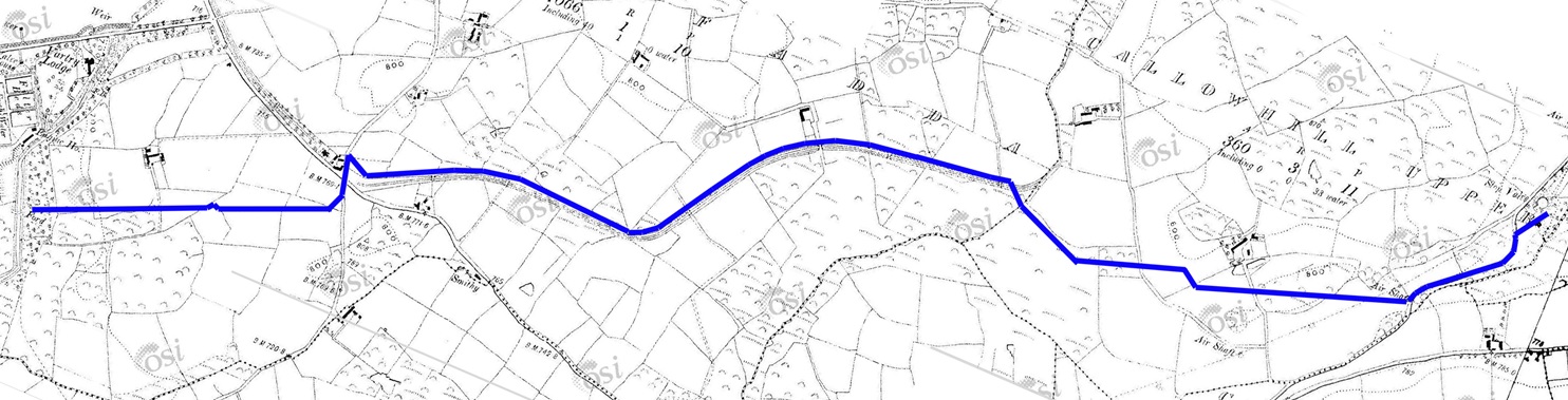
Because of structural deterioration in the original tunnel excavated in the 1860s when the Vartry Waterworks were constructed, it was decided to replace the tunnel with a pipeline. A number of other works including improvements at one of the dams and the construction of a new water treatment plant were also carried out. The pipeline runs from Vartry Water Treatment Plant to a new connection point with the existing Callowhill to Stillorgan pipeline within the townlands of Callowhill Upper, Corsillagh and Knockfadda in Co. Wicklow. The pipeline is c. 4.3km in length and follows a route traversing pasture farmland, woodland, and areas of blanket bog and road surfaces/areas of hard standing.
While evidence for prehistoric occupation in the general area is rather scanty, the various enclosures recorded in the Record of Monuments and Places suggest that occupation was fairly extensive by the early medieval period. No traces of ancient activity were found along the route of the pipeline, however. The principal structural feature in the area was the catch water with its associated walls and bridges. This would have changed the drainage of the area, so that the marshy areas must have been more extensive than today. Occasional traces of old field boundaries pre-date this, but there was no evidence that these were significantly older. Similarly, plough marks exposed during topsoil stripping appeared to have been recent. A small amount of pottery comprising sherds of plain white and Willow Pattern ware was found during topsoil stripping.
Two spreads of burnt stones were investigated alongside the catch water; these may have been caused by gorse fires, as was undoubtedly the case with the west slope of Violet Hill, where a much more extensive and patchy deposit was uncovered. A deposit of burnt stones near the Callowhill tank was thicker, and showed evidence for intense burning, but contained late 20th-century artefacts. The low mound near the pipeline, WI018-055, has been stated by the landowner to be a stockpile of clay which he had left there some time previously with a view to reclamation. The alleged ‘fairy fort’ near the crossroads displayed no enclosing features and may have been a natural feature.
One feature was found which could be identified on the first edition of the OS six-inch map. This was the road on the east face of Violet Hill, which had taken a slightly different route further up the hill. It survived as a linear deposit of small stones.
The only notable archaeological features were the elements of the industrial archaeological complex comprised by the waterworks themselves—the reservoir, dam, filter beds and tunnel.