2019:171 - NEWCOURT: Raheenacluig Church, Wicklow
County: Wicklow
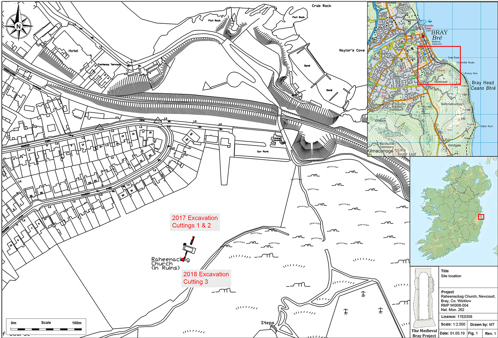
Site name: NEWCOURT: Raheenacluig Church
Sites and Monuments Record No.: WI008-004
Licence number: 17E0356
Author: David McIlreavy
Author/Organisation Address: Unit G1 Network Enterprise Park, Kilcoole, Co. Wicklow
Site type: Ecclesiastic enclosure
Period/Dating: Multi-period
ITM: E 727591m, N 717626m
Latitude, Longitude (decimal degrees): 53.193757, -6.090549
The second season of a community-led research excavation was undertaken at Raheenacluig Church (WI008-004, Nat. Mon. 262) in Newcourt, Bray, Co. Wicklow by members of The Medieval Bray Project (TMBP). The excavation was carried out during Heritage Week 2018 (18–24 August). This excavation followed on from the opening of Cuttings 1 and 2 which were investigated in 2017.
Cutting 3 abutted the external north-east wall of the church at ITM 727591, 717626 and 54.174m OD. The L-shape cutting measured 15m in length and 5m in maximum width, and was excavated to a maximum depth of 0.4m. The trench was located to target an area unavailable for geophysical survey in 2017 due to dense vegetation coverage. Where immature blackthorn saplings were encountered the trench was narrowed to minimise damage to upstanding tree stock. All spoil generated during the excavations was metal detected as per conditions stipulated within the Ministerial Consent Licence issued in conjunction with these works.
For the most part the cutting revealed topsoil C15 directly overlying subsoil C2. At the south-western extent of the trench, a mid-brown silty clay with frequent gravel inclusions, C16, immediately underlay C15. C16 had a maximum recorded depth of 0.25m. Two ceramic artefacts were recovered from C16 (2017E0356:16:1-2). Immediately Underlying C16, a dark brown silty clay, C18, was partially exposed extending south. The ceramic in C16 were both considered to be post-medieval in date, and therefore consistent with those retrieved from Cutting 1 and 2.
Towards the western end of the cutting the heavily truncated remains of a ditch, C17, were recorded. The ditch had a maximum width of 1.1m and depth of 0.51m, and was filled with a mid-brown sandy clay with stone inclusions. C19 contained elements of marine shell and terrestrial animal bone.
In conclusion, the 2017 and 2018 excavations at Raheenacluig revealed three new facets to the historical and archaeological development of the church and its immediate environs.
Firstly, the identification of a possible Neolithic or Early Bronze Age tool production site. This adds to the rich prehistoric landscape along the coastal fringe of north Co. Wicklow/south Co. Dublin.
Secondly, the excavations recorded the truncated remains of two ditch features in Cuttings 1 and 3. The ditch in Cutting 3 is considered to represent the ‘Raheen’ feature referred to in the place name evidence. Further research may indicate if the ditches are concentric, which would provide further suggestion of a previously unrecorded ecclesiastic enclosure. Analysis of the terrestrial animal bone from the C19 fill of the Cutting 3 ditch feature may provide further evidence of function and dating for at least that feature.
Finally, all excavations indicated 17th-century activity at the church. This activity may have involved reroofing of the church building using pantile, and domestic activity. Indeed, given that the Down Survey report for Bray (1650s) records the area almost devoid of inhabitants, a reoccupation of the church site in the late 1670s, even with a domestic focus, is entirely possible.
Future research will hopefully confirm the extent of the activities highlighted above, and provide further evidence relating to the construction history of the church.