2018:764 - RIVER SLANEY, Enniscorthy Flood Defence Scheme, Wexford
County: Wexford
Site name: RIVER SLANEY, Enniscorthy Flood Defence Scheme
Sites and Monuments Record No.: N/A
Licence number: 17E0250, 17R0098, 18E0359, 18D0033, 18R0124
Author: Rex Bangerter, ADCO
Author/Organisation Address: No. 2, Main Street, Bennettsbridge, Co. Kilkenny
Site type: Bridge and Quay
Period/Dating: Modern (AD 1750-AD 2000)
ITM: E 697349m, N 639955m
Latitude, Longitude (decimal degrees): 52.502290, -6.566134
ADCO, appointed project archaeologist for the Enniscorthy Flood Defence Scheme, has undertaken a series of archaeological mitigation measures as part of ongoing preparatory works associated with the scheme.
The work carried out by ADCO in 2017 and 2018 comprised detailed survey and assessment, archaeologically supervised geotechnical investigation, and test-excavation, as detailed below:
1. Building survey of ruined structure (Feature 02) located at the north end of the island formed by the River Slaney and an adjacent stream.
2. Excavation of five (5) geotechnical investigation trenches across the foundations of Enniscorthy Railway Bridge (Feature 03).
3. Test-excavation of the riverbed on the upstream side of Enniscorthy Bridge (Feature 06).
4. Excavation of geotechnical trial-pits at seven (7) locations along Abbey Quay and Shannon Quay (Features 10-11).
This was undertaken under licence from the DCHG; licence numbers 17E0250, 17R0098, 18E0359, 18D0033, and 18R0124.
The present work builds upon an existing body of work carried out by ADCO in 2015 for the National 1798 Rebellion Centre, and in 2016 as part of the Environmental Impact Assessment Report (EIAR) completed for the FDS, which recorded a series of fourteen (14) features within and adjacent to the River Slaney as it flows through the historic town of Enniscorthy.
The 2017–2018 archaeological work has generated significant additional information, based on more detailed survey and investigation/test-excavation work. It highlights the potential of the river more generally to retain significant archaeological remains, from small finds to larger structural pieces.
1. Walkover inspection of the Island upstream of the town and close to the upstream limit of the proposed flood defence works identified a ruined building (Feature 02) and recommended a detailed survey of the remains. The survey completed in 2018 identified a wider footprint of the structure underlying the standing remains. The building is built principally of stone and has a foundation that is rectangular in shape, measuring 13.85m by 9.9m in size. The building is clearly more than the ruined cowshed that presents itself today. Further work is required to determine the nature and date of the building. It occupies a prominent location within the meadow upstream of the town, while the dimensions of the structure suggest that it could either be a defensive tower building or a former watermill. The structure lies on the edge of proposed flood defence works.
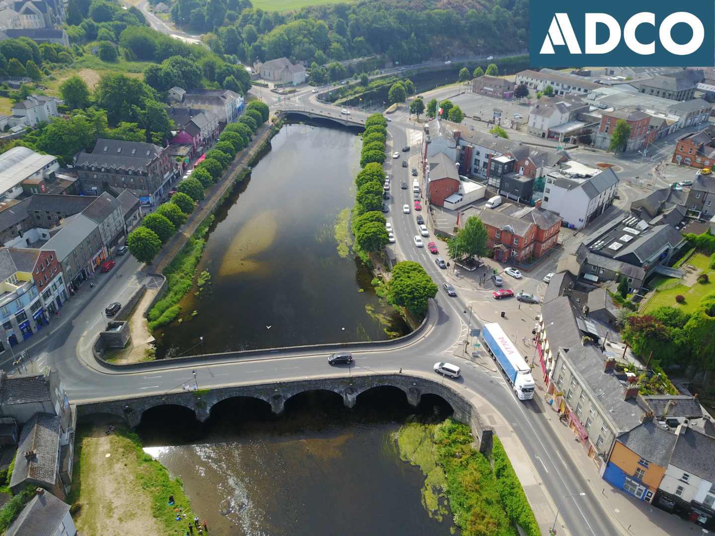
2. Enniscorthy Railway Bridge (Feature 03, NIAH 15603154) is the single remaining railway bridge on the River Slaney today. The crossing was made in 1872 and spans the river at a point 170m upstream of Enniscorthy Bridge. It measures 72m long by 3.5m wide, and has seven piers that extend seven courses in height to support a set of parallel, cast-iron girders to accommodate the track. Geotechnical investigation of the riverbed was conducted beside the bridge to address questions relating to the foundation elements of the structure. Five (5) machine-excavated trenches were made under archaeological supervision, and these were subsequently inspected underwater by ADCO. The geotechnical investigation confirmed the presence of substantial in-situ timbers related to shuttering or possible coffer-damming of the bridge piers/abutments.
3. Enniscorthy Bridge occupies a pivotal location within the FDS and is a registered site of architectural heritage (NIAH 15603154). The riverbed immediately upstream of the historic bridge retains sections of both bonded and un-bonded masonry. Investigation of these elements in 2018 confirmed that they represent pieces of collapsed bridge structure that relate to a pre-existing bridge structure/s. Two new feature numbers were generated (Features 15-16). In addition, a series of small finds, many of which comprise fired musket shot/balls (Find Numbers 18E0359:001-005, 18E0359:009-011, 18E0359:013, and 18E0359:021), were recovered from the freshly exposed surfaces (sealed contexts) associated with Features 15 and 16. The artefacts range in date from c. 1720 to 1839. It is likely that some of these items are directly associated with a number of documented skirmishes that took place on/and upstream of Enniscorthy Bridge during the Rebellion of 1798. The observation presents the strongest case yet for archaeological corroboration to the documented skirmishes at the bridge.
4. Shannon Quay (Feature 10) delineates the north-east side of the river between Enniscorthy Bridge and a point c. 15m downstream of Seamus Rafter Bridge. The structure measures c. 180m in length, approximately 1.8m in height. Abbey Quay (Feature 11) runs along the south-west side of the river parallel with Shannon Quay to the north-east. It is thought that the current structure retains both the original quay and a quay extension that was added to the downstream section in the mid-1800s. The quays were built as part of the redevelopment of the navigation channel in the early nineteenth century. They are registered in the NIAH (15603156 and 15603157 respectively). The excavation of Trenches 14–15 along Shannon Quay identified part of a buried midden (Feature 17) that was in use prior to the enquaying of the Slaney in the 1820s. The partial excavation of this feature yielded a large assemblage of post-medieval finds.
A total of seventy-nine (79) small finds were recovered as part of the recent archaeological work: twenty-nine (29) from the riverbed upstream of Enniscorthy Bridge; forty-seven (47) from the excavation of trial pits along Abbey Quay and Shannon Quay; and three (3) from the general riverbed area downstream of Enniscorthy Bridge. The majority of finds were retrieved from the buried midden (Feature 17). The assemblage ranges in date from the seventeenth to the early twentieth century, with the majority of finds dating to the 1600s. It includes, amongst other items, both imported (North Devon) and Native Irish ceramic wares (1600s-1800s), historic coins (ranging in date from 1680-1805), mining tokens (1791-1792), an iron-spur fragment (1700s), nine (9) musket balls (1722-1838), and a number of well-preserved leather pieces (a length of pigskin belt, fragments from a pigskin jerkin, and a belt piece from a horse’s girdle).
The work undertaken in 2017-2018 represents the first stage of archaeological investigation of the riverbed and has demonstrated the rich nature of the archaeological record that is retained within the river area.