2018:253 - KILNAHUE, Gorey, Wexford
County: Wexford
Site name: KILNAHUE, Gorey
Sites and Monuments Record No.: N/A
Licence number: 18E0522
Author: Steve Hickey, Courtney Deery Heritage Consultancy
Author/Organisation Address: CDHC, Lynwood House, Ballinteer Road, Dublin 16
Site type: Excavation - miscellaneous
Period/Dating: Multi-period
ITM: E 713520m, N 659339m
Latitude, Longitude (decimal degrees): 52.673315, -6.321409
In September 2018, test trenching was carried out on a proposed 15.3ha residential development. The site is located within open undulating fields in the townland of Kilnahue. The works were carried out as part of a Strategic Housing Development (SHD) application. The site is bounded to the south by the regional road R725 and some residential development, to the east by pasture fields behind residential and commercial development, to the north and north-east by a local road linking Ballyrahan and Gorey town, and to the west by open crop fields and beyond that some modern farmsteads and dwellings.
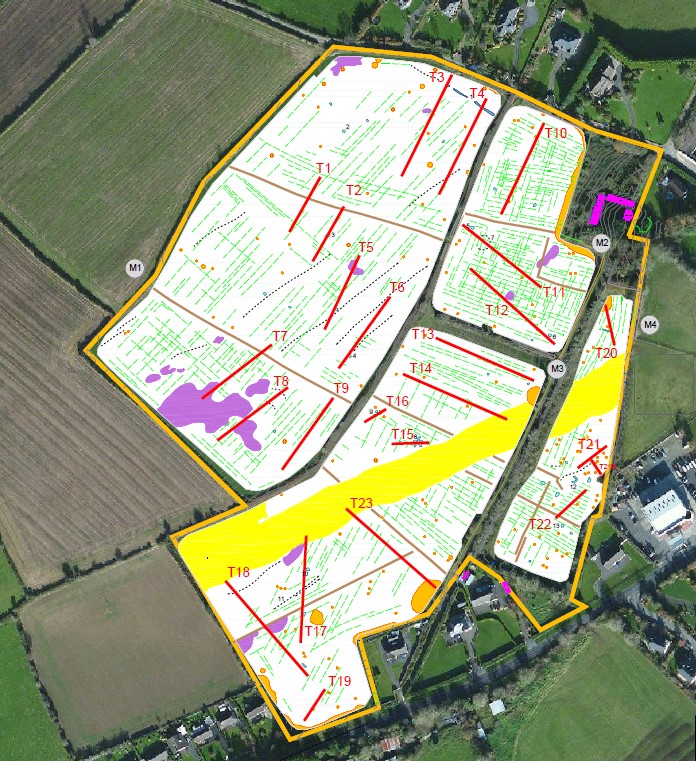
The assessment comprised the excavation of 23 test trenches throughout the site. Utilising geophysical survey results (carried out by Jo Leigh Surveys; Licence No. 18R0031) the testing programme was able to extensively cover the site as well as target the majority of archaeological anomalies. The test trenches were 1.8m in width and ranged between 30m and 80m in length, totaling 1458m of trenching.
Testing uncovered a number of archaeological/potential archaeological features in 5 of the 23 test trenches. These trenches, T2 (in field M1), T15, T17, and T18 (all in field M3), and T20 (in field M4), are not focused in one particular part of the site but spread across the application area. Other than T15 which contained a concentration of features possibly relating to kiln activity, the other 4 trenches contained a single isolated archaeological feature.
Trench T2 contained an oval pit (dimensions: 3m north-north-east/south-south-west x 1m north-west/south-east x 0.12m depth) with inclusions of charcoal and burnt clay (this feature extends into the baulk). Trench 17 contained a pit , (dimensions: 2m north-south x 0.4m x 0.15m max depth) containing small flecks of charcoal (this feature extends into the baulk). Testing works in Trench 18 uncovered an arc of 9 stake-holes (diameter 60-100mm), and , a larger stake-hole 5m to the north. The arc of stake-holes extends into the baulk and there is a likelihood of further features. The final trench to reveal any archaeological features was T20, which contained a north-east/south-west running linear feature, dimensions: 0.6m width, 1.4m length; this feature extends into the baulk and corresponds with a 7m east-west running feature identified on the geophysical survey. There is a likelihood that additional archaeological features are present in the immediate proximity of all of these identified features. All identified features were covered with plastic and back-filled.