2018:242 - PALACE EAST, Wexford
County: Wexford
Site name: PALACE EAST
Sites and Monuments Record No.: N/A
Licence number: 18E0161
Author: Sean Shanahan, Shanarc Archaeology Ltd.
Author/Organisation Address: Unit 39a Hebron Business Park, Hebron Road, Kilkenny
Site type: No archaeology found
Period/Dating: N/A
ITM: E 681094m, N 630397m
Latitude, Longitude (decimal degrees): 52.419057, -6.807816
Testing was carried out at a c. 1.5ha greenfield site at Palace East, Enniscorthy, Co. Wexford, in accordance with the requirements of Wexford County Council Planning Ref. 20171072, Condition 2.
Testing was carried out in advance of proposed land reclamation works at the site. The works involve importing 11,500 cubic metres of soil into the site for the purpose of improving the land for agricultural use. The site’s terrain slopes to the east towards the Corock River (on the east boundary) where the ground is wet and marshy.
A moated site (WX030-018) to the north and a burnt mound (WX030-076) to the south are located in close proximity (<80m) to the site. The site also lies within the former landscaped grounds of Palace House (the Palace House buildings were located to the north-west) and straddles a former tree-lined road or avenue that led from the Corock River to Palace House.
The townland boundary between the townlands of Palace East and Templenacroha, and the Civil Parish boundary between Old Ross and Adamstown, abut the site on the east side. This was identified as area of Archaeological Potential associated with a possible ancient tuath boundary.
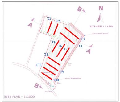
A total of 11 test trenches (numbered 1-11) measuring 1.6m in width, 0.3–0.45m in depth and from 26–39m in length were monitored.
No archaeological materials or features of significance were found during the programme of test excavation.