2018:918 - MAYNE: Mayne Bog, Westmeath
County: Westmeath
Site name: MAYNE: Mayne Bog
Sites and Monuments Record No.: WM002-038 & WM002-039
Licence number: 18E0518
Author: Tim Coughlan, c/o IAC Archaeology
Author/Organisation Address: Unit G1 Network Enterprise Park, Kilcoole, Co. Wicklow
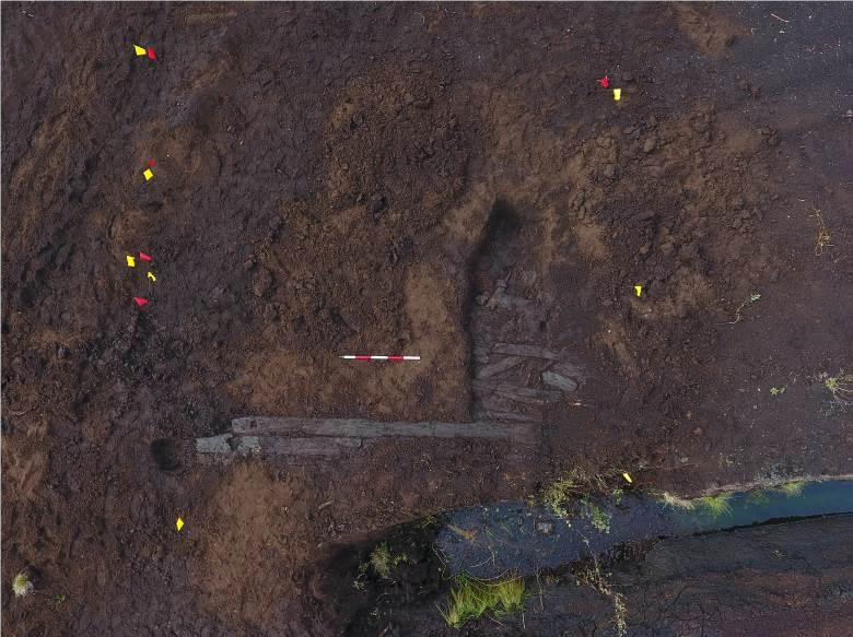
Site type: Road - class 1 togher and Structure - peatland
Period/Dating: Prehistoric (12700 BC-AD 400)
ITM: E 639674m, N 771724m
Latitude, Longitude (decimal degrees): 53.693718, -7.399279
A survey was carried out to assess the current status of two toghers located within an industrial peatland (WM002‐038 & WM002‐039). The two toghers had been identified and recorded in previous surveys, and a number of seasons of excavation in 2006 and 2015 have preserved by record portions of both sites. The assessment follows a consultation process between Westland Horticulture and the National Monuments Service where it was agreed that a detailed assessment survey would be appropriate to evaluate the current status of the sites.
The archaeological assessment and survey were carried out over the course of four days from 10 September 2018. The survey involved the walking and visual inspection of linear drains within the industrial peat-production bog. Both of the previously-identified toghers were the subject of further detailed inspection and recording along their length including a metal-detection survey within a 15m buffer of the centreline. The metal detection survey produced no positive results.
The survey confirmed that the plank togher (WM002‐038) is intact in the extreme east (Field 1 only: 14m) and extreme west (Field 44 and to the west: 30m) of the industrial bog, with some moderately intact sections although disturbed in the east (approximately 70m in total – Fields 2–9). There are some further surviving elements in the eastern half of the bog but these are generally restricted to localised areas in the centre of fields (3–5m in length). With the exception of the surviving 30m in the west of the bog, there is no other evidence of the site in the western half of the bog.
The brushwood togher WM002‐039 was previously identified in the eastern half of the bog only, and there was no expectation that any remains would be identified in the west, and none were. The survey confirmed it was only fully intact in Field 1, and as with the plank togher it was moderately intact in the east of the site (Fields 2–9) but beyond this evidence was sporadic at best. There was little evidence west of Field 16 and no evidence was identified west of Field 26.
Two additional sites were identified during the survey. Both were located in the south of the bog. Site 3 consisted of a stake-row alignment orientated north-north-east/south-south-west and extending for approximately 50m. Site 4 consisted of a Structure Peatland, possibly a platform. Site 4 was heavily disturbed by a drain and as such it was difficult to interpret the nature and extent of the identified remains. It was constructed of multiple species, with evidence of tool marks over an area 26m in length. While both sites were not immediately adjacent, a direct association cannot be ruled out. Site 3 has been dated to the Middle Bronze Age and Site 4 has been dated to the Early Iron Age.