2018:738 - WATERFORD CITY, Waterford
County: Waterford
Site name: WATERFORD CITY
Sites and Monuments Record No.: WA009-005
Licence number: E004487
Author: Órla Scully
Author/Organisation Address: 7, Bayview, Tramore, X91 X462
Site type: Historic town
Period/Dating: Multi-period
ITM: E 660894m, N 612318m
Latitude, Longitude (decimal degrees): 52.259195, -7.108011
In High Street, in the centre of the road as it meets the junction of Olaf Street, a stone wall was exposed revetted into the earth at the southern side, and the northern (downhill) side showed a loose fill of mostly red brick indicating a back-filled cellar (19th century). The wall was battered.
Two vertically truncated walls extended northwards from the section of stone wall, 1.8m apart. The size and appearance of this stone feature indicates the remains of an erstwhile gardrobe pit. The street has already yielded evidence of a 15th-century urban tower-house (93E0056). The stone feature exposed may be the remains of a previously un-mapped house in this area. The wall was on line with the frontage of houses further east in the street, but the direction of the chute indicates an outer wall, which would put the house in the centre of the High Street at the point where it meets Olaf Street, which is anomalous.
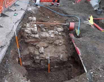
In Colbeck Street, at the southern end of the street, a section of the city wall was exposed. It was excavated over 3 days by hand. The wall was partially overlain by a later stone and brick structure on line with the original street frontage prior to street widening. The wall was planned, levelled and photographed. The town wall was revetted into the gravel substrata of the hill. It was almost 2m wide, and the southern face was abutted by post-medieval rubble, which overlay a brown organic silt which was left in situ. It was then securely covered by terram, and backfilled with gravel before work resumed without any damage to the surviving masonry.