2018:384 - WATERFORD: 22 Lady Lane, Waterford
County: Waterford
Site name: WATERFORD: 22 Lady Lane
Sites and Monuments Record No.: WA009-00502
Licence number: 18E0420
Author: Órla Scully
Author/Organisation Address: 7 Bayview, Tramore, Co. Waterford
Site type: Historic town
Period/Dating: Multi-period
ITM: E 660854m, N 612343m
Latitude, Longitude (decimal degrees): 52.259424, -7.108593
Proposed plans to construct an apartment block to create 14 inner city apartments in land to the rear of the property at No. 22 Lady Lane and the adjoining property to the rear of the Badminton Club (a 19th-century Presbyterian church) are still in design stage and testing was carried out to further inform the planning process. Though Lady Lane is one of the oldest streets in the city (roughly parallel to Peter Street and High Street which radiate westward from the apex of the Viking Triangle), it was gentrified in the Georgian period and many cellars have removed archaeological deposits at the street frontage.
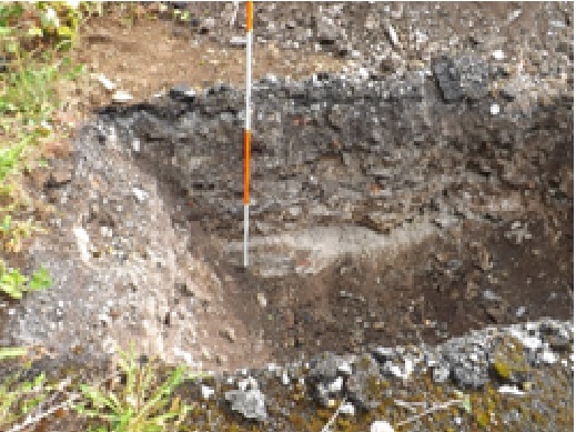
The rear of the site is bounded by the town wall, where it borders on, and retains, the land from Spring Garden Alley at the south, which lies over 3m below the surface of the properties behind Lady Lane. 10 test trenches were excavated. To the rear of the church, a brick paved surface was exposed at a depth of 0.4m bounded at the north by a kerb overlain by willow-patterned ware. An area of bricks was removed, exposing a mortar bedding overlying a dark soil containing more willow pattern ware, one yellow and one brown small pot and some bottle glass. At a depth of 0.8m the midden-like material overlay a layer of mortar-rich stone rubble, in which a concentration of purple slate was noted. The remains of a section of wall, 0.6m wide, located 1.2m from the east end of the trench running north-south, was exposed and left in situ. Though finds were 18th/19th century, the potential for archaeological survival below this was deemed high and no further excavation was carried out. In the land further away from the street, beneath the modern car park surface, was a dark garden soil with some willow pattern ware. At a depth of almost 1m a piece of roof tile (18th/19th century, J. Wren, pers. comm.) was retrieved, marking the start of a higher stone content with some purple slate in a matrix of garden soil. At a depth of 1.49m, occasional oyster shell made an appearance and a sherd of medieval pottery was found at this level. Though no structures were evident, no further excavation was done as the medieval sherd was evidence of archaeological survival.
In another trench located 9m south of the town wall, under a stony rubble layer with frequent red brick in a mortar-rich silt, a darker silt yielded a sherd of Saintonge ware at a depth of 1.27m. Excavation did not proceed further than this depth.
In essence, the site had been infilled to create a surface level with the street at the north (Lady Lane) in the post-medieval period. The land had formerly sloped steeply to the south. The original silts, which more than likely formed backyards of perhaps Viking Age, but certainly medieval houses are still largely undisturbed beneath the infill, and the site is deemed to be of definite archaeological significance.