2018:221 - CARRICK-ON-SUIR: Abbey Hill, Carrickbeg, Tipperary
County: Tipperary
Site name: CARRICK-ON-SUIR: Abbey Hill, Carrickbeg
Sites and Monuments Record No.: N/A
Licence number: 18E0572
Author: Seán Shanahan, Shanarc Archaeology Ltd.
Author/Organisation Address: Unit 39a, Hebron Business Park, Hebron Road, Kilkenny
Site type: Historic town
Period/Dating: Multi-period
ITM: E 639773m, N 621543m
Latitude, Longitude (decimal degrees): 52.344042, -7.416285
Monitoring of construction groundworks associated with alterations to an existing structure, a former public house; as per the conditions of Tipperary County Council planning reference number 18600642.
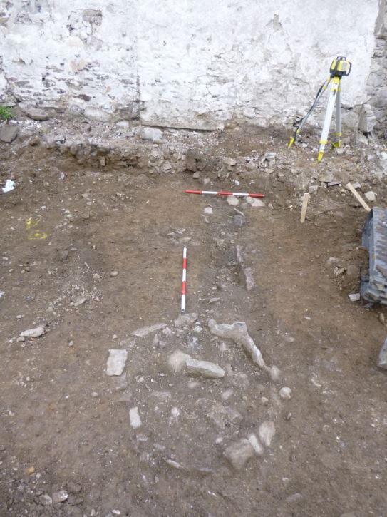
A linear drain like feature 45cm wide x 14cm deep, was exposed in the rear or southern part of the site. It was covered by a topsoil or rubble overburden layer. The drain extends 2.5m into the property from the western boundary, ending at its visible east extent with an oval or sub-circular shaped feature delineated by a sub-circular arrangement of stone. The drain, which has a flat, clay base, is also lined with stone on both sides that were more apparent on the north side of the drain cut. The sub-circular component at the east end measured 1.17 m N–S x 2.30 m E–W, and may represent a sump associated with the drainage system. The fill of both the linear component and sub-circular component of the drain was similar, and comprised a moderately compact mid-brown clayey silt with frequent inclusions of small sized angular stones and a moderate amount of charcoal flecks.
Two postholes were also revealed to the south of the drainage feature, generally sited in the southwest corner of the development footprint. The postholes measured 17cm & 18cm in diameter; both contained the remnants of quite well decayed timbers.
As all these features were situated in part of the development footprint that was to remain as an open plan garden, it was proposed to preserve the features in-situ.
In the absence of excavation, no datable finds were recovered from the features. From datable finds recovered in topsoil or overburden at the site, it is interpreted that the drain features probably relate to an 18th or 19th century building shown on the 1839 and 1886 edition OS maps.