2018:914 - MOYNALTY STEAM THRESHING MUSEUM, Meath
County: Meath
Site name: MOYNALTY STEAM THRESHING MUSEUM
Sites and Monuments Record No.: ME011-011
Licence number: —
Author: Niall Roycroft
Author/Organisation Address: c/o Meath County Council
Site type: Mound
Period/Dating: Medieval (AD 400-AD 1600)
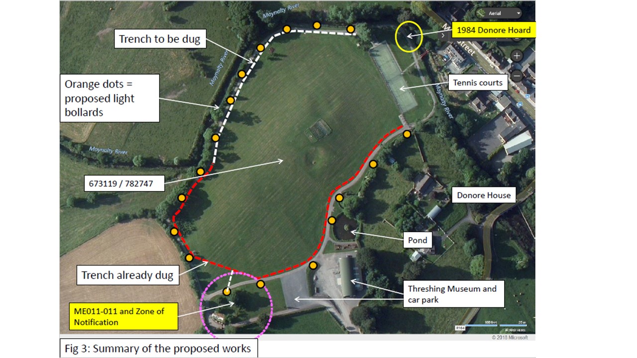
ITM: E 673119m, N 782747m
Latitude, Longitude (decimal degrees): 53.789146, -6.890348
Meath County Council is constructing public lighting along the foot and vehicle looped trackway in the Moynalty Steam Threshing Museum exhibition field. The centre of the field is at ITM 673119/782747. The looped trackway (used for both pedestrians and maintenance vehicles) is approximately 650m long and the ducting trench is to be constructed on the inner side of it, with offset trenches to the lighting standards (bollard type) which are generally on the outer side of the track. The works were previously halted with approximately 480m of ducting trench 0.3m wide x 0.6m deep already dug. The monitoring was for the remaining trench 200m long and 18 connections from this ducting trench to each of the light standards. One lighting bollard is adjacent to Mound ME011-011 inner bank, well inside the now razed outer banks. A desk-based Assessment was undertaken in April 2018.
‘Mound’ ME011-011 is possibly a double ditched, raised ringfort around 70m long x 55m wide. OS mapping shows part of the outer bank but only a tiny part of this now survives. The inner, raised, mound has been around 60% truncated during the 20th century. The area around the mound has been landscaped and a footpath placed over the northern area where an outer bank may have been. The present Borora River forms the Threshing Field site boundary to the north-west, north and north-east of the site. The river now lies in a dredged and canalised channel and the Threshing Field banks have been raised to form low, flood-defensive bunds alongside it. Behind the bund is the modern looped footpath.
The southern bank of the Borora River in the north-eastern corner of the Threshing Field is the 1984 findspot zone for the 9th century Donore Hoard. The Donore Hoard shows outstanding examples of early medieval metalwork and the ‘handle’ features in the National Museum of Ireland ‘A history of Ireland in 100 objects’ exhibition. How these ecclesiastical treasures came to be buried here is not known. The location plaque for the Donore Hoard findspot is c. 30m from the end of the proposed lighting works.
There are several cropmarks (some perhaps relating to an 1837 mapped lime kiln and probable quarry) and cultivation ridges across the Threshing Field. Adjacent Donore House possibly is the site of a tower-house castle (on the Down Survey) and the recently reinstated pond and stream may once have formed part of a defensive bawn for Donore House.
In April 2018, works were halted after c.400m of trench 0.4m x 0.6m deep had been dug for light ducting. Works were resumed in September 2018 with a monitoring planning condition, but the archaeologist was not informed until a significant part had been completed. However, sufficient groundworks were observed to confirm that the Borora River and the Pond-stream areas have mostly been embanked with redeposited soils and ‘Mound’/Ringfort ME011-011 has been thoroughly razed beyond the standing remains. However, the presence of any surviving below-ground inner and/or outer ditches at ME011-011 could not be confirmed.