2018:032 - READLAND, ROESTOWN AND KNOCKS, Meath
County: Meath
Site name: READLAND, ROESTOWN AND KNOCKS
Sites and Monuments Record No.: N/A
Licence number: 15E0125
Author: Steven McGlade, Archaeology Plan
Author/Organisation Address: 32 Fitzwilliam Place, Dublin 2
Site type: Excavation - miscellaneous
Period/Dating: Multi-period
ITM: E 695880m, N 752630m
Latitude, Longitude (decimal degrees): 53.514894, -6.554321
A programme of monitoring and subsequent excavation was carried out on a site in Readsland, Roestown and Knocks, just west of Dunshaughlin, Co. Meath from May 2018 to March 2019. The site was divided into two phases, Phase 1 to the south of the Drumree Road within Readsland and Knocks townlands and Phase 2 to the north within Roestown townland.
Phase 1 prehistoric activity
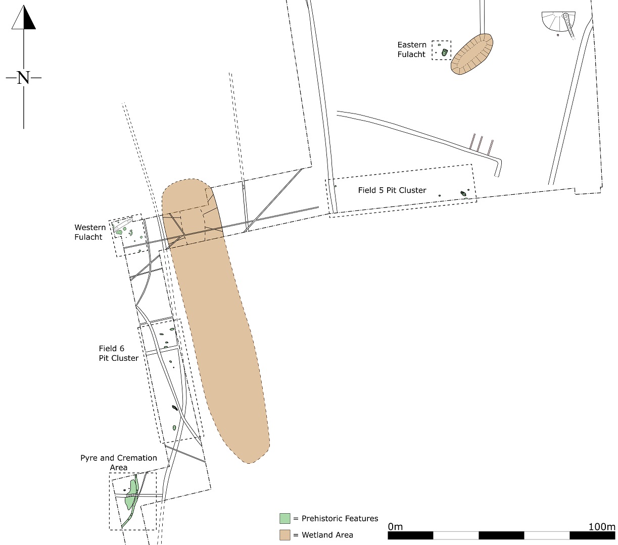
Prehistoric activity was identified near the lower-lying former wetlands to the south of the site. A large spread measuring c.13.5m by 4m representing a cremation pyre was uncovered with a small cremation pit and a second possible cremation pit nearby. Very little charcoal survived within the pyre spread, however fragments of burnt human and animal bone were identified throughout the material, which also exhibited light scorching. The pyre spread was truncated by a medieval field boundary ditch and by an earlier curving ditch, which may be late prehistoric in date.
A second smaller pyre pit measuring 3.6m by 1m was also uncovered in lower-lying ground nearby. A large flint hollow scraper was retrieved from the feature. Two possible cremation pits and a cluster of additional pits were uncovered in the vicinity of the pyre pit.
A second pit cluster was uncovered to the north-east, with another flint hollow scraper being retrieved from one of the pits.
Two fulachta fiadh sites were also uncovered. The western fulacht fiadh had one simple sub-circular trough and a number of additional pits, two of which may originally have been troughs, however were too poorly survived to say with certainty. The burnt mound was also poorly surviving and patchy. The eastern fulacht fiadh was sub-rectangular in plan. A number of stake- and post-holes survived around the edges of the trough indicating it had been lined with wood. The associated burnt spread for the eastern fulacht fiadh had also largely been ploughed away.
Phase 1 medieval activity
A medieval field system, originally dating to the 12th-14th century, was identified across the Phase 1 fields. This was associated with a medieval laneway uncovered just to the south of the existing Drumree Road. This may have been an earlier alignment of the Drumree Road. The road overlay a number of small gullies, which related to the early medieval settlement to the north within Phase 2.
A semi-circular dipped area with a metalled drain built into the base was uncovered to the east and may represent the remains of a medieval metalworking workshop. The area had a beaten earth floor and was interpreted as the remains of a lightweight structure as no uprights were identified. The beaten earth floor contained several iron artefacts and slag, along with medieval ceramics. The northern portion of the structure was truncated by a modern field boundary.
Phase 2
A substantial early medieval cemetery settlement was identified and partially excavated within Phase 2 of the development. A summary of the findings for Phase 2 will be given in the 2019 entry for the site.


