2018:817 - MULLAGHARLIN, Dundalk, Louth
County: Louth
Site name: MULLAGHARLIN, Dundalk
Sites and Monuments Record No.: LH012-005001, LH012-005002
Licence number: 18E0114
Author: Jon Stirland, Archaeological Consultancy Services Unit
Author/Organisation Address: Unit 21, Boyne Business Park, Greenhills, Drogheda, Co. Louth
Site type: Excavation - miscellaneous
Period/Dating: Multi-period
ITM: E 704935m, N 803799m
Latitude, Longitude (decimal degrees): 53.972810, -6.400480
The site was identified during testing by Jon Stirland of Archaeological Consultancy Services Unit in March 2018. Subsequently excavation was carried out between 3 April and 4 May 2018.
The site was located adjacent to LH012-00500, an enclosure, and LH012-005002, a souterrain, both located within the townland of Mullagharlin.
Two areas of archaeology were identified and excavated, Area 1 and Area 2.
Area 1 measured 60m by 60m and was located along the southern extent of the proposed development. Area 2 measured 10m by 10m and was located north of Area 1 and was towards the centre of the proposed development site.
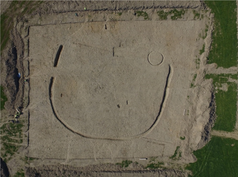
A number of features were exposed in Area 1 and consisted of a large C-shaped enclosure ditch, a circular slot trench, which represented the remains of a structure, a figure-of-eight-shaped kiln, a kiln/cooking pit, an oval-shaped post-hole, a storage pit, a linear feature and cultivation furrows.
In Area 2 a single feature, a large spread, was identified. There were no finds associated with this feature. The function of this feature is not clear.
The features identified spanned many centuries and attest to the presence of a community within this site from as early as the Late Iron Age right through to the Early Medieval period. Post-medieval/modern activity was also identified through the presence of the aforementioned cultivation furrows.
Radiocarbon dating has proved essential in aiding our understanding of the site and identifying successive phases of occupation. The earliest known phase of activity was represented by the slot trench which in all likelihood represented the remnants of a circular structure and was dated to the 2nd-4th century AD. The next phase of activity was represented by the kiln which was dated to the 7th-8th century AD whilst the latest radiocarbon date obtained was recovered from the upper recut in the C-shaped enclosure ditch and was dated to the 13th century AD.
Although no radiocarbon date was obtained from the lower fills of this aforementioned enclosure ditch, it is likely that it was utilized over an extended period and was in all likelihood used in conjunction with and by the same population which constructed the kiln. The occurrence of kilns in close proximity to and in conjunction with enclosure sites is a feature typical of the early medieval period in Ireland. It is also likely that the kiln/cooking pit, located within the area defined by the enclosure ditch, is also contemporary and that both features dates to the early medieval period.
This is, therefore, a multi-period site. It essentially consists of an isolated Late Iron Age structure. Oak recovered from the slot trench would suggest that the structure was constructed from oak. A very small quantity of cereal grains (3) were recovered from this slot trench. The C-shaped enclosure was a ditched enclosure; no evidence of a bank remained. A western and eastern terminus was identified. An entrance-way was also identified along the western extent of this ditch. An attempt was made to define the northern extent of this enclosure at some stage following its construction and was represented by a much smaller, less substantial ditch that was evident to the north. No dateable material was recovered from this feature but it respected the eastern and western termini of the C-shaped enclosure, a factor which would suggest that the enclosure was visible at the time this linear feature was excavated. No evidence of a contemporary, internal structure was identified. A single feature was contained within the interior, the remnants of a kiln/cooking pit.
Very few finds were recovered from this site, the majority being from the topsoil. The only finds of note were a piece of flint debitage and a flint thumbnail scraper recovered from the basal fill of the C-shaped enclosure. Animal bone was also recovered in very small quantities. The lack of faunal remains recovered would suggest that no butchery or food preparation took place within this site. Cereal processing was conducted on this site, as evidenced by the presence of the cereal-drying kiln and the possible kiln/cooking pit and the recovery of cereal grains. The identification of a recut within this enclosure ditch is indicative of the longevity of usage of this site. The wood taxa recovered from the features attributed to the early medieval period were considerably more varied (hazel, ash and alder were the main taxa identified). The presence of these taxa in the early medieval period would suggest that the landscape surrounding this enclosure was more open than during the preceding Late Iron Age period.
It is likely that the C-shaped enclosure was not a settlement site. It was probably utilized as an animal enclosure or used in conjunction with cereal processing. The predominance of barley grains recovered from this site would, however, suggest that this site was utilized and occupied by lower status members of the society (farmers). The enclosure at Mullagharlin was therefore likely a small farmstead/field system and could possibly have been utilized by those who occupied the enclosure to the north-east (LH012-005001) or that to the south-west (LH012-118) or an as of yet, unidentified settlement enclosure.

