2018:791 - MAIDENHEAD (1), Laois
County: Laois
Site name: MAIDENHEAD (1)
Sites and Monuments Record No.: N/A
Licence number: 18E0236
Author: David Bayley, c/o IAC Ltd.
Author/Organisation Address: Unit G1 Network Enterprise Park, Kilcoole, Co. Wicklow
Site type: Enclosure and Field system
Period/Dating: Multi-period
ITM: E 664490m, N 684985m
Latitude, Longitude (decimal degrees): 52.911833, -7.041197
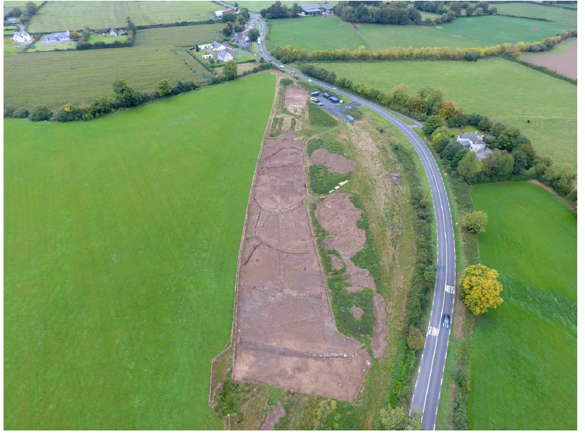
The excavation of a potential enclosure site, Maidenhead 1, followed on from previous phases of archaeological investigations including desktop assessment, geophysical survey and test trenching, carried out as part of the N80 Maidenhead Realignment Scheme, Co. Laois. This work was undertaken on behalf of Laois County Council and Transport Infrastructure Ireland.
The potential enclosure at Maidenhead 1 is a newly discovered site (not previously recorded) and its initial discovery was through geophysical survey, where both magnetometer and resistivity results indicated the presence of a potential circular enclosure placed centrally in the roadtake.
The excavation at Maidenhead 1 followed on from a programme of Stage (i) testing undertaken in March and April 2018 by David Bayley of IAC Ltd under licence 18E0130.
Stage (iii) excavation works at Maidenhead 1 took place from May to September 2018. Two archaeological cuttings were opened for this site.
Cutting 1 incorporated a number of meandering silt and gravel-filled alluvial channels/ditches crossing the northern half of the cutting, associated with a former watercourse(s). To the south of this was an isolated, undated but possibly prehistoric, burnt spread with an associated trough, containing heat-shattered stone, representing pyrolithic (burnt mound-type) activity.
A possibly later, more extensive phase of archaeological activity, consisted of a potential enclosure ditch and southern annex. The aforementioned meandering silt and gravel-filled alluvial channels/ditches may have formed the enclosing element for the northern half of the enclosure. A possible west-facing entrance was noted beyond the limit of excavation in the geophysical survey.
In the interior of the enclosure, a series of pits (possibly post-pits), post-holes, stake-holes, gullies, slot trenches, hearths and a kiln were recorded, several arranged in a roughly east-west alignment, potentially representing a structure(s) or building.
A southern annex conjoined the potential enclosure and re-cut of the original enclosing ditch, suggesting a later phase of activity. In addition, further radial and parallel ditches were identified which appear to be associated with a radial field system.
An expanded field system was also identified to the north of the potential enclosure, but with significant differences in form and deposit to those recorded in the south. It was unclear whether these field systems were contemporary or even fulfilled the same function.
The finds from Cutting 1 consisted of an array of iron blades and nails, as well as spindle whorls, a hone stone, pins, a decorated jet-like bracelet, and two glass (blue and yellow) beads. The nature of the artefacts from the site suggest that it was likely to have been a domestic settlement of some significance, potentially dating to the Late Iron Age or early medieval period.