2018:903 - KILKENNY: Abbey Quarter (The Mayfair Building), Kilkenny
County: Kilkenny
Site name: KILKENNY: Abbey Quarter (The Mayfair Building)
Sites and Monuments Record No.: KK019-026
Licence number: C000798, E004822, 17R0248
Author: Jon Stirland, Archaeological Consultancy Services Unit
Author/Organisation Address: 21, Boyne Business Park, Greenhills, Drogheda, Co Louth
Site type: Historic town
Period/Dating: Multi-period
ITM: E 650422m, N 656324m
Latitude, Longitude (decimal degrees): 52.655759, -7.254744
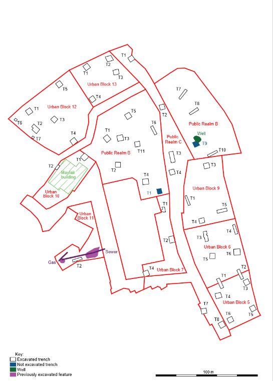
Archaeological test trenching was carried out as part of a pre-development assessment strategy for the Abbey Quarter Masterplan area in Kilkenny city, a major 8.25ha redevelopment encompassing the former Diageo or Smithwick’s Brewery, which ceased operations in 2013. The focus of excavations was within the former Diageo Brewery site. The site extends along 650m of the Nore riverside, stretching from the rear of properties on St Kieran’s Street, Parliament Street, Watergate, Irishtown and Vicar Street in the west to the River Nore on the east; from Green Street in the north to Bateman Quay and the Market Yard car park to the south. The proposed development consists of Urban Blocks numbered from 1 to 14, and Public Realms lettered A to D. Urban Block 10, containing the Mayfair Building, was investigated under Section 14 Ministerial Consent C000798 because of its proximity to Kilkenny’s city wall, the boundary wall with the River Breagagh. Additional test trenches in the Brewery site were excavated under Section 26 licence number 17E0642 and Section 14 Ministerial Consent C000853.
Urban Block 10 is c.0.16ha in area and consisted of the footprint of the existing Mayfair Building and an adjoining car park. The area is bounded on the north by a wall separating the site from the Breagagh River; this wall incorporates the remains of Kilkenny’s city wall, and as such is a national monument. It fronts on to Watergate Street and Horse Barrack Lane to the west, and extends into the former Diageo Brewery site to the east.
Two test trenches were excavated in Urban Block 10. Trench 1 was within the site of a proposed extension to the Mayfair Building and was excavated in order to investigate the site of the former Horse Barracks and possible features associated with the precinct of St Francis’ Abbey (KK019-026101-). Trench 2 was located to the rear of the Mayfair Building, on the southern side of the River Breagagh, and was excavated in order to determine the condition of the riverside wall and depth of deposits between the wall and the Mayfair Building.
Trench 1 measured 6.13m x 5.74m and was excavated to a depth of 1.9m (43.05m OD), exposing two wall lines and a cobbled surface, below which was a dark brown garden soil that contained disarticulated and articulated human burials. The cobbled surface and wall lines were recorded at a depth of 0.64m below the current ground level and the deposit containing the human burials was recorded at a depth of 1.16m below the current ground level (cranium exposed at 43.79m OD and burial exposed at 43.42m OD). No dating evidence was retrieved to definitively date the walls and cobbled surface. Their appearance and a review of cartographic evidence, however, suggests that they may be associated with the former Horse Barracks, built around 1700, which is depicted on Rocque’s map of Kilkenny (1758) and the Valuation Town Plan 1:1056 (c. 1850). The deposit within which disarticulated and articulated human burials were recorded appears to represent a burial deposit pre-dating the Horse Barracks and most likely associated with the graveyard of St Francis’ Abbey. On the advice of Laureen Buckley, osteoarchaeologist for the project, the articulated remains were left in situ and excavation ceased at this level.
Analysis of the disarticulated human remains by Buckley has identified a total number of four individuals: two male adults and two juveniles, one an adolescent and the other an unaged juvenile. There was one complete left radius and the diameter of the head was in the male range. Using the length of this bone the stature was determined as 1.74m.
The artefacts recovered from Trench 1 comprised post-medieval ceramic and pottery sherds, glass bottles, iron objects including nails, a fragmented roof slate and clay pipe bowl and stem fragments from the upper layers associated with the construction and use of the Horse Barracks. Three sherds of medieval pottery were also recovered from these layers. The garden soil/burial layer similarly contained four green glass bottle sherds, a possible iron nail, one corroded copper object and four sherds of post-medieval pottery, but also one sherd of medieval pottery and seven fragments of medieval tiles, one of which represented a roof ridge tile with the remaining six from floor tiles.
Trench 2, excavated beside the boundary wall with the River Breagagh, measured 4.88m x 2.5m and was excavated to a depth of 0.84m (44.48m OD), exposing a flagstone floor. No dating evidence was recovered, however it appears to date to the nineteenth-century building and predates the construction of the Mayfair Building. The flagstone surface occurs at the same level as an arch through the riverside wall leading to a demolished bridge (Cotteral’s Bridge) across the River Breagagh and may represent riverside access to this bridge. The stone-built wall running alongside the river comprised a section of repaired wall that overlies the city town wall, and as such is a national monument.
The results of this test excavation will be used to prepare a strategy for preserving the archaeology in situ during the development of the Abbey Quarter Masterplan.