2018:905 - KILKENNY: Abbey Quarter, Kilkenny
County: Kilkenny
Site name: KILKENNY: Abbey Quarter
Sites and Monuments Record No.: KK019-026
Licence number: C000853, E004950, 17R0473
Author: Jon Stirland, Archaeological Consultancy Services Unit
Author/Organisation Address: Unit 21, Boyne Business Park, Greenhills, Drogheda, Co Louth
Site type: Historic town
Period/Dating: Multi-period
ITM: E 650531m, N 656347m
Latitude, Longitude (decimal degrees): 52.655956, -7.253130
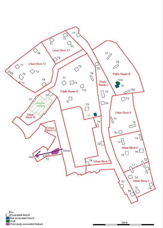
Archaeological test trenching was carried out as part of a pre-development assessment strategy for the Abbey Quarter Masterplan area in Kilkenny city, a major 8.25ha redevelopment encompassing the former Diageo or Smithwick’s Brewery, which ceased operations in 2013. The focus of excavations was within the former Diageo Brewery site. The site extends along 650m of the Nore riverside, stretching from the rear of properties on St Kieran’s Street, Parliament Street, Watergate, Irishtown and Vicar Street in the west to the River Nore on the east; from Green Street in the north to Bateman Quay and the Market Yard car park to the south. The proposed development consists of Urban Blocks numbered from 1 to 14, and Public Realms lettered A to D. Seventeen test trenches in four areas, or parts of areas, were excavated under Section 14 Ministerial Consent C000853: Public Realm B Trenches 1–8, 10 and 11, Urban Block 7 Trench 1, Urban Block 9 Trenches 1, 3 and 5 and Public Realm C Trenches 2–4. Additional areas in the Abbey Quarter were excavated under Section 26 licence number 17E0642 and Section 14 Ministerial Consent C000798 and as such are detailed under those licence numbers. All the areas were covered in concrete slab or floors from the recently demolished Diageo buildings. The requirements for test excavations were specified by Kilkenny County Council in advance. For each test trench the concrete was cut and with the trench excavated with the assistance of a mechanical digger. To finish, after recording, the trenches were backfilled and capped with concrete.
Urban Block 7 is c. 0.14ha in area, located in the centre of the Masterplan area within the former Diageo Brewery site and consisted of open ground, a concrete surface and the ground floor footprint of recently demolished buildings. The area is located east of the Brewhouse Building and south of the remains of St Francis’ Abbey. Trench 1 was located at the northern extent of Urban Block 7, measured 5.05m x 3.78m, was excavated to a depth of 3.3m and exposed part of a stone wall, aligned roughly east–west, and an associated cobbled surface, below which a preserved garden soil was recorded. The waterlogged garden soil has the potential to range in date from the medieval period through to the 16th–19th centuries. Cartographically these gardens/agricultural lands appear to be associated with the development of gardens and orchards as depicted on Rocque’s map of 1758, and prior to the development of the orchards and gardens was probably a low-lying meadow subject to flooding in the winter months, but traditionally used for summer grazing. A property boundary wall at the approximate location of the wall in Trench 1 is also depicted on Rocque’s map (1758). The majority of the finds retrieved were post-medieval red brick, iron fragments, 18th–19th-century floor tiles, pottery and clay pipe stems and bowls, although two sherds of 12th–13th-century green glazed pottery (E004950:235:5–6) were also recovered.
Urban Block 9 is c. 0.28ha in area, located at the north-eastern corner of the medieval town of Kilkenny (KK019-026) and within the former precinct of St Francis’ Abbey (KK019-026101-). Trench 1 measured 9.93m x 2.32m and was excavated to a depth of 1.5m; the area was heavily disturbed, including the truncation of a section of a stone-built wall that appears to be in line with a garden plot wall or property boundary depicted on Rocque’s map (1758). Trench 3 measured 5.39m x 5.22m and was excavated to a depth of 3.21m. Preserved garden soil and an underlying alluvial deposit were exposed, neither of which contained artefacts. Trench 5 measured 9.97m x 3.06m and was excavated to a depth of 3.49m. Below a layer of industrial waste of Victorian date was a possible preserved garden soil that contained inclusions of red brick and a clay pipe stem, and an underlying alluvial deposit.
Public Realm B surrounds the National Monument of St Francis’ Abbey (KK019-026101-). The area is bisected by Public Realm C, bounded by the River Nore to the east, Evan’s Turret and a short section of standing city wall and the River Breagagh to the north. Ten test trenches were excavated within Public Realm B (Trenches 1–8 and 10–11) to investigate the area immediately surrounding St Francis’ Abbey. Trench 9 was not excavated because of the presence of a large waterfilled concrete tank surrounding St Francis’ Well. The trench measurements were as follows: Trench 1 was 5.95m x 5.2m x 1.88m deep; Trench 2 was 5.06m x 5.05m x 1.57m deep; Trench 3 was 5.86m x 5.48m x 1.49m deep; Trench 4 was 5.85m x 5.46m x 2.8m deep; Trench 5 was 5.41m x 5.24m x 1.1m and 1.99m deep within two evaluation trenches; Trench 6 was 9.06m x 2.53m x 2.98m deep; Trench 7 was 11.14m x 2.14m x 1.82m deep; Trench 8 was 9.61m x 2.33m x 1.68m deep; Trench 10 was 10.28m x 2.18m x 3.28m deep; Trench 11 was 5.07m x 5m x 3.27m deep. Human burials were recorded in Trenches 1, 2, 3, 5 and 11, associated with the graveyard of St Francis’ Abbey. These ranged in depth between 43.55m OD and 42.71m OD (top), potentially date from the medieval period onwards (the articulated and disarticulated remains are suggestive of multiple phases of burial) and extend beyond the limits of the excavated trenches. Stone-built walls were documented in Trenches 2 and 3, ranging in depth from 44.02m OD to 43.53m OD (top) respectively. These were associated with the abbey church, most likely representing the western wall of the nave and the north wall of the chantry chapel or northern transept. Wall lines were also seen in Trenches 1 and 5 (43.77m OD and 43.61m OD (top) respectively), as well as a stone-built drain at a depth of 43.6m OD (top); these were associated with buildings depicted on the 6-inch map of 1842–50 and 25-inch map of 1900. The wall and drain in Trench 1 are also depicted on Rocque’s map (1758) and appear to be associated with the Horse Barracks’ eastern range of buildings. The barracks was built in c. 1700, while the associated buildings were built in the 18th to 19th centuries. It is also possible that this may have been a reused wall of an earlier building of possible late medieval/medieval date. High levels of ground disturbance and modern reclamation deposits associated with the development of the St Francis Abbey Brewery and the later Smithwick’s Brewery were seen in Trenches 4, 6 and 11. Preserved garden soils were documented in Trenches 1, 5, 6, 7, 8, 10 and 11; these ranged in depth from 43.73m OD to 42.05m OD (top) and have the potential to date from the medieval period onwards. For example, in Trench 1 several medieval pottery and tile fragments were associated with a possible garden soil (43.09m OD, top), while in the case of Trenches 7 and 8, the garden soils (42.9m OD and 43.73m OD, top, respectively) are thought to be 19th/20th century in date. The excavation of Trenches 7 and 8 were halted at a depth of 1.7–1.8m because of unstable ground and a high groundwater table. The preserved garden soils and an alluvial organic silty clay (43.02m OD, top) identified in Trench 10 produced a number of worked oak timbers and a possible stone revetment (42.48m OD).
Public Realm C is c. 0.48ha in area, and extends through the Abbey Quarter from St Francis’ Street in the north, across the River Breagagh, past St Francis’ Abbey, and terminating at the Market Yard in the south. Trenches 2, 3 and 4 investigated the precinct of St Francis’ Abbey, the possibility of burials, and post-medieval buildings associated with the St Francis Abbey Brewery. Trench 2 measured 5.06m x 4.89m and was excavated to a depth of 2.8m, exposing a preserved garden soil and alluvial deposit, neither of which contained any artefacts. Trench 3, immediately east of St Francis’ Abbey, measured 10.78m x 4.18m and was excavated to a depth of c. 1.4m; excavation was halted because of the presence of a concrete pipe. This pipe truncated a wall that appeared to be aligned on a wall depicted on Rocque’s map of 1758, the 25-inch map of Kilkenny (1900) and the Valuation Town Plan of c. 1850, suggesting this it did not represent the Abbey precinct wall but was more likely to be a relatively modern and mirrored earlier property boundaries/wall lines. Trench 4 measured 5.11m x 5.04m and was excavated to a depth of 2.81m, exposing upper and lower levels of garden soils and a lower alluvial deposit; some 17th–early 18th-century pottery was recovered from the upper garden soils but there was no datable material from the lower levels.
The results of these test excavations will inform the strategies for the future development of the Abbey Quarter.