2018:904 - KILKENNY: Abbey Quarter, Kilkenny
County: Kilkenny
Site name: KILKENNY: Abbey Quarter
Sites and Monuments Record No.: KK019-026
Licence number: 17E0642, 17R0248
Author: Jon Stirland, Archaeological Consultancy Services Unit
Author/Organisation Address: Unit 21, Boyne Business Park, Greenhills, Drogheda, Co Louth
Site type: Historic town
Period/Dating: Multi-period
ITM: E 650521m, N 656287m
Latitude, Longitude (decimal degrees): 52.655418, -7.253287
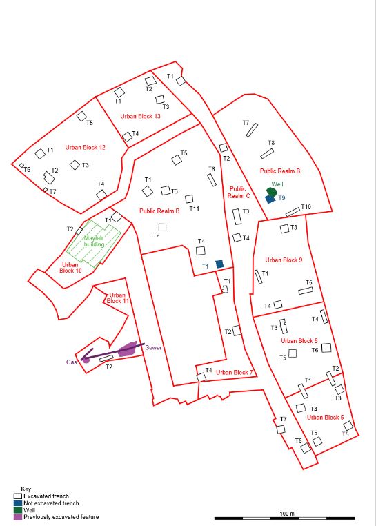
Archaeological test trenching was carried out as part of a pre-development assessment strategy for the Abbey Quarter Masterplan area in Kilkenny city, a major 8.25ha redevelopment encompassing the former Diageo or Smithwick’s Brewery, which ceased operations in 2013. The focus of excavations was within the former Diageo Brewery site. The site extends along 650m of the Nore riverside, stretching from the rear of properties on St Kieran’s Street, Parliament Street, Watergate, Irishtown and Vicar Street in the west to the River Nore on the east; from Green Street in the north to Bateman Quay and the Market Yard car park to the south. The proposed development consists of Urban Blocks numbered from 1 to 14, and Public Realms lettered A to D.
Twenty-eight test trenches were excavated in eight areas, or parts of areas: twenty-two trenches in Urban Blocks 5, 6, 11, 12 and 13, two trenches in Urban Block 7, one in Urban Block 9 and three in Public Realm C. Additional test trenches in the Brewery site were excavated under Section 14 Ministerial Consents C000798 and C000853.
Seven areas were covered in concrete slab or floors from the recently demolished Diageo buildings; Area 11 consisted of a car park surfaced in tarmac. The requirements for test excavations were specified by Kilkenny County Council in advance. For each test trench the surface was cut and the trench excavated with the assistance of a mechanical digger. To finish, after recording, the trenches were backfilled and capped with concrete.
Urban Block 5 is c. 0.18ha in area, located in the southern sector of the former Diageo Brewery site and primarily consists of the site of a modern industrial building recently demolished. Six test trenches were excavated within Urban Block 5; Trenches 1 and 2 straddled the boundary between Urban Blocks 5 and 6 and revealed a shuttered concrete surface that appears to have been constructed over the route of a millrace. The trench measurements were as follows: Trench 1 was 10.22m x 2.74m x 4.16m deep; Trench 2 was 10.36m x 3.09m x 4m deep; Trench 3 was 5.28m x 5.1m x 3.59m deep; Trench 4 was 5.95m x 5.67m x 2.56m deep; Trench 5 was 5.14m x 5.1m x 3.6m deep; Trench 6 was 5.14m x 5.02m x 3.85m deep. All six trenches confirmed that this part of the former brewery site has been subject to a high level of modern ground disturbance, with reclamation deposits associated with the development of the brewery overlying Victorian building rubble and preserved garden soil. The latter waterlogged garden soil has, however, the potential to range in date from the medieval period through to the 16th–19th centuries. Cartographically these gardens/agricultural lands appears to be associated with the development of gardens and orchards as depicted on Rocque’s map of 1758, and prior to the development of the orchards and gardens was probably a low-lying meadow subject to flooding in the winter months, but traditionally used for summer grazing. These garden soils were uncovered at levels ranging in depth from 40.63m OD to 43.13m OD across the six trenches, occurring at a depth of 1.58–2.28m below the current ground level. No datable artefacts were recovered from these garden soils. The remains of a wall were also exposed at a depth of 0.45–0.83m below the current ground level (44.14–44.15m OD) within Trenches 5 and 6 and cartographic evidence suggests that it represents the rear wall of a former market building depicted on the 25-inch (1:2500) map of Kilkenny (1900) and the Kilkenny town plan of c. 1850.
Urban Block 6 is c. 0.28ha in area, located in the southern sector of the former Diageo Brewery site and primarily consisted of the site of a modern industrial building, demolished to ground floor slab level. Four test trenches were excavated within Urban Block 6. The trench measurements were as follows: Trench 3 was 9.92m x 3.4m x 3m deep; Trench 4 was 9.45m x 2.55m x 4.1m deep; Trench 5 was 5.26m x 5.1m x 3.43m deep; Trench 6 was 6.28m x 5.94m x 3.02m deep. Trenches 3 and 4 identified a shuttered concrete culvert which covers the route of the medieval/post-medieval millrace at a level of 42.57m OD. Trenches 3, 5 and 6 also recorded the presence of preserved garden soils, recorded at an average level of between 43.38m OD and 42.83m OD, representing a depth of 1.24–1.8m below the present ground level. No artefacts were recovered from Urban Block 6.
Urban Block 7 is c. 0.14ha in area, located in the centre of the Masterplan area within the former Diageo Brewery site and consisted of open ground, a concrete surface and the ground floor footprint of recently demolished buildings. Trench 1 was excavated under Ministerial Consent C000853. Trenches 2 and 4 were located in the southern half of Urban Block 7. The proposed Trench 3 was not excavated. Trench 2 measured 6.52m x 4.8m and was excavated to a depth of 3.33m, exposing a stone wall aligned north–south, with a stone-lined drain running alongside the wall, and a second truncated stone wall aligned east–west. The Irish Historic Towns Atlas Map 2 (Bradley 2000), based on maps from 1842–1850, depicts a range of buildings labelled ‘St Francis Abbey Brewery’ at this location. The eastern wall of this range of buildings appears to be aligned with the wall and associated stone drain and the pottery recovered from the drain fill would also suggest an 18th–19th-century date. The wall and drain were located above and partly within a preserved garden soil, which in turn overlay an alluvial deposit. No dating evidence was retrieved to date the garden soils, although the base deposits of Trench 2 did produce a fragment of an oak plank and a spruce stake with evidence of woodworking, identified by Dr Lorna O’Donnell. Trench 4 measured 5.41m x 5.36m and excavation was halted at a depth of 0.4–0.99m due to the presence of a concrete slab covering the culverted millrace.
Urban Block 9 is c. 0.28ha in area, located at the north-eastern corner of the medieval town of Kilkenny (KK019-026) and within the former precinct of St Francis’ Abbey (KK019-026101-). Trenches 1, 3 and 5 were excavated under Ministerial Consent No. C000853. Trench 4 was located in the south-western corner of Urban Block 9, measured 5.22m x 4.8m; excavation was stopped at a depth of 1.94m due to the presence of possible contamination. The trench revealed high levels of modern ground disturbance related to the former Diageo Brewery, overlying 1.38m thick industrial waste deposits with glass and pottery sherds that appeared to represent a Victorian phase of land reclamation.
Urban Block 11 is c. 0.13ha in area, located in a car park for the former Diageo Brewery site between The Ring, The Watergate Theatre, and Parliament Street. It was originally proposed to excavate four trenches within Urban Block 11, however, due to the presence of services, access issues concerning fire exits of the Watergate Theatre car park and concerns regarding the gable wall of 35 Parliament Street, it was agreed in consultation with Kilkenny County Council that it was only possible to excavate one test trench in this area. Trench 2 was located within the Watergate Theatre car park and measured 9.58m x 2.18m and was excavated to a depth of 1.52m. An angular section of stone-built wall (45.96 OD at top) and a cobbled surface were exposed. These features appear to relate to a boundary wall depicted on the 25-inch map of Kilkenny (1900), or to a corner of a building depicted on the Valuation Town Plan (c. 1850). The wall did not contain any medieval fabric and inclusions of red brick were evident. Both the wall and associated cobbled surface are considered to be 18th–19th century in date. No further features or deposits of an archaeological nature were identified within the trench.
Urban Block 12 is c. 0.38ha in area, located to the north of the Breagagh River in Gardens townland and consisted of an open yard and car park area and recently demolished buildings of the former Diageo Brewery site. The area is bounded to the south by the Breagagh River behind a modern river wall and to the north by the St Francis’ Street. The western part of Urban Block 12 contains the upstanding remains of the Bull Inn (KK019-026107-): an early 17th-century hostelry fronting onto St Canice’s Place. Seven test trenches were excavated in Urban Block 12: Trench 1 was 5m x 4.95m x 2.5m deep; Trench 2 was 8m x 5.3m x 2.89m deep; Trench 3 was 5m x 5m x 2.15m deep; Trench 4 was 4.9m x 4.26m x 3.9m deep; Trench 5 was 4.86m x 4.81m x 1.35m deep; Trench 6 was 2m x 2m x 1.18m deep; Trench 7 was 2m x 2m x 1m deep. High levels of modern ground disturbance and reclamation deposits associated with the development of the former Diageo Brewery were seen in all seven test trenches, while the excavations of Trenches 5 and 7 were halted at depths of 1.1m and 1m respectively below current ground level because of possible contaminants. Two levels of cobbled surfaces were recorded in Trench 1. An upper level that appeared to be of 18th–19th-century date and a lower level with an associated wall that was exposed at a depth of 44.26m OD and appears to be of possible late medieval date (16th/17th century). Below this were two phases of possible garden soils, recorded to a depth of 43.12m OD and possibly representing medieval occupation. Beneath these, a pit cut into the natural boulder clay extended to a depth of 42.62m OD and contained oyster shell and animal bone fragments mainly identified as horse. Two cobbled surfaces were also recorded in Trench 2, along with two walls exposed at depths of 44.5m and 44.04–43.74m OD, the construction and general appearance of which also suggest a possible late medieval date. Below the cobbled surfaces, three phases of possible garden soils were identified and these may similarly represent medieval occupation and were recorded to a depth of 41.84m OD. A single course stone wall of possible post-medieval date was exposed in Trench 3 at a depth of 43.66m OD. The base of this wall overlay three deposits that may represent three phases of garden soils that were recorded to a depth 42.64m OD. These may represent post-medieval and/or medieval garden soils. In Trench 4 modern reclamation deposits and a possible 18th–19th-century garden soil extended from 43.79m OD to a depth of 41.16m OD. Within this garden soil, a 0.5–0.7m thick deposit of loose stone along the northern area the trench may have been used to stabilise the ground alongside the River Breagagh. A stone wall of possible post-medieval date was also exposed within Trench 5 at a depth of 43.65m OD. Trenches 6 and 7 were located within the Bull Inn. These trenches identified 18th–19th-century reclamation deposits consisting of dumps of stone, building rubble and domestic waste and represent phases of raising the ground level within the Bull Inn. It is possible that the walls and cobbled surfaces in Trenches 1 and 2 may represent a courtyard and outbuildings associated with the Bull Inn. A large assemblage of artefacts was recovered from Urban Block 12, much of which was 18th to 20th century in date, comprising ceramic and pottery sherds, glass, clay pipe fragments, leather and iron nails; of note was a single, unidentifiable coin (17E0642:058:1) from Trench 1 and a gold posy ring (17E0642:060:1) from Trench 2. The outer surface of the gold ring is undecorated but the internal surface bears the inscription ‘Let no calamity Separate amitty’; these ring types were popular from the 15th to 17th century.
Urban Block 13 is c. 0.2ha in area, also located to the north of the Breagagh River in Gardens townland and consisted of an open yard and car park area and recently demolished buildings of the former Diageo Brewery site east of Urban Block 12. Four test trenches were excavated within Urban Block 13. Trench 1 measured 5.4m x 5.3m x 3.05m deep, Trench 2 measured 6m x 5.3m x 3.53m deep, Trench 3 measured 5.3m x 4.86m x 4m deep and Trench 4 measured 5.16m x 5.05m x 2.7m deep. The area had been subject to a high level of modern ground disturbance with reclamation deposits associated with the development of the former Diageo Brewery site, including the reclamation of a water course depicted on the Valuation Town Plan of c. 1850. These modern reclamation deposits were between 43.32m OD and 41.9m OD. Below these were various garden soil layers and/or peaty/alluvial deposits, which extended to 42.06m to 40.84m OD. A single base sherd of internally green glazed pottery of 12th–13th-century date (E0642:45:1) was recovered from a garden soil/alluvial deposit in Trench 3.
Public Realm C is c. 0.48ha in area, extends from north end of the Brewery, across the River Breagagh south to the Market Yard; it runs to the immediate east of the upstanding remains of St Francis’ Abbey. Six test trenches were excavated in Public Realm C: Trenches 1, 7 and 8 were excavated under licence 17E0642; trenches 2, 3 and 4 were excavated under Ministerial Consent C000853; the proposed Trenches 5 and 6 were not excavated. Trench 1, at the north end of Public Realm C, measured 5.12m x 4.96m but work was halted at a depth of 0.9m because of possible contamination. Trench 7, at the south end of Public Realm C, measured 5.3m x 5.12m and was excavated to a depth of 3.2m. It contained phases of 18th- and 19th-century reclamation and associated developments of shallow garden soils, overlying a lower preserved garden soil and alluvial silty clay. Similar deposits were exposed in Trench 8, which measured 5.59m x 5.46m x 2.82m deep, as well as a masonry wall for a market building depicted on the OSI 25-inch map of Kilkenny from c.1900.
The results of these test excavations will inform the strategies for the future development of the Abbey Quarter.
Reference
Bradley, J. 2000 The Irish Historic Towns Atlas No. 10, Kilkenny. Royal Irish Academy, Dublin.