2018:549 - INISTIOGE WATER SUPPLY SCHEME, Kilkenny
County: Kilkenny
Site name: INISTIOGE WATER SUPPLY SCHEME
Sites and Monuments Record No.: KK032-017017 (National Monument)
Licence number: C000649 E0004552 R000363
Author: Graham Hull, TVAS (Ireland) Ltd
Author/Organisation Address: Ahish, Ballinruan, Crusheen, Co. Clare
Site type: Historic town
Period/Dating: Multi-period
ITM: E 663460m, N 637850m
Latitude, Longitude (decimal degrees): 52.488367, -7.065599
Monitoring was carried out during groundworks associated with pipe laying for the Thomastown and Inistioge Water Supply Scheme. Part of the works lay within the historic core of Inistioge town, which is not only a Recorded Monument but also a National Monument. Works were consequently carried out under consent. The remainder of the scheme was monitored under licence 17E0375.
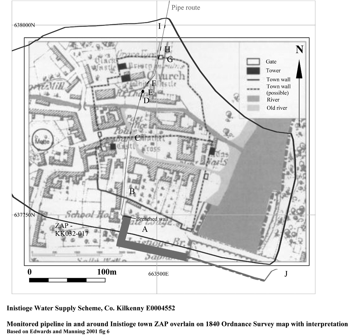
Monitoring within Inistioge town revealed stone walls, human remains, building surfaces and old road surfaces dating from the medieval, post-medieval and modern periods. Results are described by area within the town and shown on the accompanying figure.
Area A – The demolition of a stone wall at a greenfield site south of the town was monitored. A stone drain and cluster of stones was also found.
Area B – Monitoring of the point where the pipe trench crossed the line of the town wall showed that the potentially medieval wall had previously been breached by a sewer. The new pipe was laid along the line of the existing sewer to avoid further impact on the wall.
Area C – Monitoring at the junction of Main Street and the R700 encountered a stone wall at the predicted point of the medieval abbey precinct wall. The upper 0.2m of the wall was removed to facilitate pipe-laying. The wall was found to be 1m wide and at least 0.55m high and interpreted as a wall foundation or possible road surface. Fragments of 13th- to mid-14th-century Saintonge pottery, 17th- to early 18th-century clay tobacco pipe, undated clay tobacco pipe and post-medieval glass were recovered from the pipe trench. In addition medieval and post-medieval pottery was recovered from spoil.
Area D – Monitoring on the R700 recorded a vestigial wall (approximately 0.8m wide and at least 0.4m high), mortar floor and a series of successive floor or occupation deposits with evidence of burning. Finds included mid-13th- to 14th-century Kilkenny ware pottery and ridge tile and post-medieval pottery. Unstratified finds included more mid-13th- to 14th-century Kilkenny ware pottery, post-medieval pottery, brick and glass.
Area E – Monitoring north of Area D close to the Church of Ireland graveyard uncovered articulated and disarticulated human bone, possibly medieval.
Area F – Monitoring on the R700 north-east of Area E uncovered another wall.
Area G – Monitoring on the R700 at the north side of Inistioge at a point thought to be the location of the gate in the medieval town wall uncovered a cobbled road surface and part of a stone structure, possibly a town gate with spud stone. Post-medieval pottery and an undated clay tobacco pipe stem were recovered from the collapsed structure. A metalled surface was also found, thought to be an earlier version of the Thomastown to New Ross road.
Area H – Monitoring on the R700 found a possible wall or culvert and old metalled road surface.
Area I – Monitoring on the R700 recorded another possible wall or culvert and an old metalled road surface.
Area J – Monitoring on the east bank of the River Nore south of Inistioge Bridge encountered no archaeological deposits or features.
Figure is from: Edwards, D and Manning, C, 2001, ‘A Seventeenth-Century Map of Inistioge, Co. Kilkenny’, Journal of the Royal Society of Antiquaries of Ireland 131, 38-55