2018:839 - LISSANISKA RINGFORT, Kilcolman, Kerry
County: Kerry
Site name: LISSANISKA RINGFORT, Kilcolman
Sites and Monuments Record No.: KE047-054
Licence number: 17E0328 ext.
Author: Ed Lyne, Archaeological Consultancy Services Unit
Author/Organisation Address: Unit 21, Boyne Business Park, Greenhills, Drogheda, Co Louth.
Site type: Ringfort - rath
Period/Dating: Medieval (AD 400-AD 1600)
ITM: E 481929m, N 600273m
Latitude, Longitude (decimal degrees): 52.141680, -9.725021
An archaeological excavation was carried out at Lissaniska (Kilcolman Td.) in advance of the approved N70 Kilderry Bends Improvement Scheme. The work was carried out on behalf of Kerry County Council and Transport Infrastructure Ireland. The site was assessed during Stage (i) archaeological testing (17E0328) and metal detection survey (17R0136) carried out by Archaeological Consultancy Services Unit (ACSU) on behalf of Archaeological Management Solutions (AMS) during September 2017. The Stage (iii) excavation was carried out by Ed Lyne between 18 December 2017 and 23 February 2018 under an extension to the testing licence, which was transferred from Ian R. Russell.
The site, in the townland of Kilcolman, consisted of part of recorded monument KE047-054, a trivallate ringfort known as ‘Lissaniska’ (Lios an Uisce, ‘the ringfort of water’). A portion of the ringfort (c. 21.02%) lay within the Lands Made Available (LMA) for the construction of the road scheme. This affected area comprised solely of the enclosing elements on the northern side of the ringfort, with the interior of the ringfort located outside of the LMA. Construction works will therefore remove part of the monument.
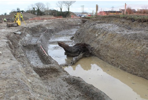
The excavation area contained part of the three ditches surrounding the ringfort, as well as some bank remains. The ringfort was depicted as univallate on the first edition six-inch OS map (surveyed 1840, published 1846), while aerial photography analysis carried out by Laurence Dunne identified that it appeared to be bivallate (Dunne 2014). Geophysical survey (using resistivity) in advance of the approved development clearly identified a third ditch (Gimson & Bonsall 2015). A large area was opened up around the ringfort within the LMA, and cleaned back by hand. A possible entrance to the ringfort identified to the north-north-west during geophysical survey was not evident during excavation. Two shallow pits that contained significant quantities of charcoal were identified to the north-east of the ringfort. A large number of cultivation furrows and several drainage features were also identified, suggesting an episode or episodes of tillage, probably in the 19th–20th centuries.
The inner ditch measured on average c. 5.25m wide, and generally had a depth of c. 1.4–1.65m. It had a U-shaped profile overall, with a stepped profile on the outer side that also consisted of a smaller U-shaped cut. This was in effect a shallow channel or series of rectilinear pits/troughs running along the side of the ditch, which may have served an industrial/agricultural function, perhaps connected to flax retting based on the recovery of a sheaf of flax in the base of the ditch. It was divided into parts (or troughs) by regularly spaced ridges in the bedrock. The base of the main part of the ditch was also divided by a series of transverse ridges or, in some cases, steps in the bedrock through which it was cut, pointing at some form of water management. This inner ditch, the most substantial of the three, had a number of fills that fell into three categories, primary silting-up layers, organic accumulation layers, and finally sterile backfill layers that appeared to be the result of post-medieval land improvement works. An organic layer and the primary silting up layer were the only deposits to produce artefacts likely to be contemporary with the ringfort. These comprised of both carved and stave-built wooden vessels, possibly related to dairy activity and used as churns and/or butter containers. It would be logical that the inner ditch would contain more artefactual material than the outer ditches, as it was directly adjacent to the habitation area, assuming there had not been a deliberate effort made to keep the ditch waste free. Neither the middle nor outer ditches produced any artefactual material.
The middle ditch measured on average c. 3m wide, and generally had a depth of 1–1.15m. It had a U-shaped profile, with steep to moderately steeply sloping sides, and a flat base. As with the inner ditch, its fills generally fell into three categories, silting-up layers, organic accumulation layers, and finally sterile backfill layers that appeared to be the result of post-medieval land improvement works. In general, the organic layer in the middle ditch was peatier and less humic than that in the inner ditch. The base of this ditch was also divided by a series of transverse ridges, or in some cases steps in the bedrock, again pointing to some kind of water management.
The outer ditch varied significantly in scale from east to west; it measured between 1m and c. 3m wide, narrowing significantly from east to west, with its depth varying between 0.8m and 1m. It had a U-shaped profile towards the east, with steeply sloped sides, and a flat base, which again was divided by a series of ridges of bedrock, in this case some of which did not extend fully across the base of the ditch. Towards the west it became more V-shaped or blunt V-shaped as it narrowed. As with the other two ditches, its fills generally fell into three categories, silting-up layers, organic accumulation layers, and finally sterile backfill layers which appear to be the result of post-medieval land improvement works. The organic layer in the outer ditch, as in the middle ditch, had a greater peat content and was less humic than the inner ditch.
Where bank material was encountered (mainly between the middle and outer ditch), it comprised a sterile clay deposit surviving to between c. 0.03m and 0.25m in thickness, probably representing material generated during the digging of the upper part of the ditches. This bank material overlay a thin peaty layer, interpreted as the old topsoil layer from the time before the enclosure was constructed. A single artefact was recovered from this layer, a Neolithic type leaf-shaped flint arrowhead, was probably lost here by a hunter in prehistoric times.
Overall, the ditch form seen at Lissaniska was both complex and unusual, and points to its builders having followed a very definite construction plan with a specific purpose in mind. At the very least, water management seems to have been a concern, though to precisely what end is less clear. The recovery of well-preserved flax stems and pods in one area of the inner ditch may point to flax retting being at least one of the functions of these elaborate ditches. It is hoped that the proposed macro-environmental and pollen analyses will help shed further light on this question.
References
Dunne, L. 2014. Archaeological Assessment Report, Kilderry Bends Improvement Scheme, Milltown, Co. Kerry. Unpublished report for Kerry County Council.
Gimson, H. & Bonsall, J. 2015. N70 Kilderry Bends Improvement Scheme & Castlemaine to Milltown Improvement Scheme, Kilderry, Kilcolman & Cloonmore townlands County Kerry: Archaeological Geophysical Survey. Unpublished report for Kerry County Council.