2018:812 - BAILE AN SCEILG: Ballinskelligs Abbey, Kerry
County: Kerry
Site name: BAILE AN SCEILG: Ballinskelligs Abbey
Sites and Monuments Record No.: KE097-036
Licence number: E004993; C000815
Author: Laurence Dunne
Author/Organisation Address: 3 Lios Na Lohart, Ballyvelly, Tralee, Co. Kerry
Site type: Religious house - Augustinian canons and Graveyard
Period/Dating: Multi-period
ITM: E 443373m, N 565020m
Latitude, Longitude (decimal degrees): 51.815462, -10.271820
Phase 1 of archaeological investigative works in Ballinskelligs Abbey and Graveyard was undertaken during four days in June 2018 under Ministerial Consent No. C000815. The objectives of the work were to determine the presence or otherwise of sub-surface archaeological features pertaining to the southern limits of the Refectory and the possible subsurface remains of the ‘Cell’ structure.
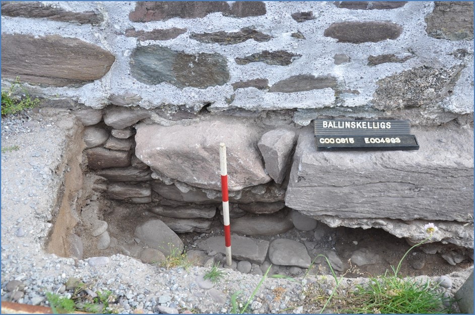
Overall, four investigative cuttings were opened. Cutting 1 (2.45m x 1.5m and a depth of between 0.48m–0.6m) was located at the collapsed eastern end of the northern side wall of Refectory and was subsequently extended tightly along the interior of the wall.
Cleaning and investigation of the ragged east-facing end section of the north side wall revealed that it had been scoured out and partially undermined by extreme storm action. The scour was then repaired by underpinning the ragged remains by inserting large sandstones that were bedded with cement and laid on a thin layer of locally-derived beach cobbled concrete. The concrete bedding layer overlay a very indurated stony surface. A small slot was opened in the indurated surface but noting of archaeological interest was recorded.
Cutting 2 (2m L x 1.4m W x 0.6m) was opened on the perimeter pathway at the calculated location of the eastern limits of the southern sidewall of the Refectory between the sea wall and a modern grave. No evidence of the south sidewall of the Refectory was found in Cutting 2.
Cuttings 3 & 4 were opened in proximity of the ‘Cell’ wall, which is a single short (c.1.2m long x c.0.8m high) east-west orientated remnants of clay bonded structure. The relict remains of the structure is denoted as a ‘Cell’ attached to the northern sidewall of the now destroyed Sacristy on the 1915 plan of the abbey.
Cutting 3 (2.35m x 0.4-0.6m and depth between 0.3-0.55m) was opened from the ‘Cell’ wall and extended to the north sidewall of the Chancel. Only a very short section of the ‘Cell’ wall survived subsurface in the northern part of the cutting. Otherwise the fill of the cutting comprised loose, random rubble of mixed material resulting from the digging of nearby modern graves. Some disarticulated human bone fragments were recovered. No further remains of the ‘Cell’ were present, and the wall overlies pure beach sand.
Cutting 4 (1.1m x 1m and depth between 0.35–0.6m) was opened at the northern end of the ‘Cell’ wall. A very small section of the original wall was found at the western corner of the cutting only. There was no trace of it returning to the east. The maximum height of the sub-surface remains of the wall was 0.45m. The base of the cutting below the wall consisted of pure beach sand. The fill comprised of randomly mixed stones including topsoil material and broken modern slates. The investigation revealed that there was no continuance of the ‘Cell’ wall subsurface in Cutting 4.