2018:452 - Barnastooka, Kerry
County: Kerry
Site name: Barnastooka
Sites and Monuments Record No.: N/A
Licence number: 18E0324
Author: David Murphy
Author/Organisation Address: John Cronin & Associates, 3 Westpoint Business Centre, Ballincollig, Cork
Site type: Burial cairn
Period/Dating: —
ITM: E 505838m, N 571152m
Latitude, Longitude (decimal degrees): 51.884579, -9.367827
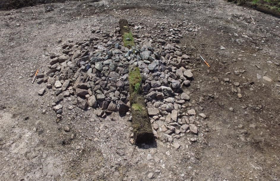
During licensed monitoring (16E0127) of groundworks at the Grousemount Wind Farm development site, a concentration of loose, dry stones was discovered at the south-western end of the T.32 hardstand in Barnastooka townland. The stone concentration was situated in a position where it could not be avoided by wind farm construction works and, as such, preservation in-situ was not feasible. Following consultation with ESBWDL and subsequent to the approval of NMS, excavation of the feature was undertaken. During the excavation it became apparent that the concentration of dry-stones revealed at surface level was in fact the upper portion of a substantially larger cairn. Following further consultation and approval from the NMS, the cairn was fully excavated. Excavation revealed the cairn to be a burial cairn containing a small sub-rectangular cist of Bronze Age ‘short cist’ type.
The cairn comprised of two distinct stone deposits, which overlay a small sub-rectangular cist. A purposely deposited metalled surface was revealed extending in a general south-eastward direction from the south-eastern edge of the outer cairn deposit. The full extent of the cairn deposit measured 7.5m north-west/south-east by 6.3m, with a maximum height of 0.8m. The main cairn deposit consisted of loose and randomly placed, small to large sub-rounded and sub-angular sandstones, with occasional varying size angular shale inclusions, as well as very occasional large quartz pebble inclusions. In the central portion of the cairn, the upper stone deposit overlay a more organised deposit of generally larger stones. These stones were predominantly set on edge and were angled inwards towards the centre of the cairn. They sat upon the underlying soil and were not set within it. This differing type of stone deposit was largely concentrated in the north-east and north-west quadrants as opposed to the south-east and south-west quadrants where the random loose stones predominantly continued down to the underlying soil. The manner in which the stones were stacked, with no peaty soil inclusions between, suggests one purposeful phase of deposition, creating a solid core, on this side of the cairn.
Revealed in the very centre of the cairn, underlying the upper stone deposit and abutted by the larger stacked stones in the north-east and north-west quadrants, was a small sub-rectangular cist. The cist was constructed with four thin, sub-rectangular, reddish grey sandstone slabs, set on edge to create a sub-rectangular box. A fifth sandstone slab placed on top of the vertically set slabs acting as a primary capstone, a larger upper capstone overlay the primary capstone. The vertical slabs were positioned within an introduced deposit of purplish grey clayey silt and small to medium sized angular stones. The purpose of this localised deposit was to provide a solid and secure base into which the vertical slabs of the cist were set. The maximum external dimensions of the cist were 0.6m east-west on its south side and 0.51m east-west on its north side. It measured 0.55m north-south externally. Due to its sub-rectangular shape the internal dimensions of the cist differed slightly as measured from the end of each slab. The north to south internal dimensions, as measured from the base of the cist, were 0.49m north-south at its western side, 0.48m north-south at its eastern side. Similarly, the east to west dimensions also differed being 0.39m east-west at its southern side and 0.37m east-west at its northern side.
The interior of the cist was predominantly empty but its lower portions contained two fills, the upper fill comprised a mix of clayey silt and natural manganese-like mineral formation, while the basal fill comprised a mix of small to medium angular stones and clayey silt. The basal fill was essentially the same as the previously mentioned introduced deposit and acted as a solid and secure base into which the vertical slabs of the cist were set. The higher level of the basal interior fill compared with the outer introduced deposit prevented the inward collapse of the vertical slabs of the cist. Some of the stones within both deposits were purposely positioned and angled to act as supporting wedges or pegs for the lower portions of the cist slabs.
The metalled surface was composed of a dense and compact deposit of varying sized and shaped stones contained within a matrix of dark brown peaty soil; it extended south-eastwards from beneath the outer stones at this side of the cairn. It measured c.9.5m north-west/south-east by c.6.1m and had a general depth of between 0.1-0.2m. The majority of the stones within the surface were purposely positioned so that their flatter surfaces were facing upwards. The mix of stone and peaty soil filled what appeared to be a natural depression in the subsoil and also slightly negated the natural downward sloping gradient of the area. The metalled surface underlay undisturbed stones inwards from the very outer edges of the cairn and, as such, can be considered to predate the deposition of the upper cairn deposit, in particular its south and south-eastern portions. However, the surface does not underlie any of the organised and inwardly stacked stones and was not revealed underlying the core area of the cairn. It is likely that the deposition of the metalled surface was either contemporary with or slightly post-dated the construction of the inner cairn and cist, however, as no stratigraphic relationship existed between them, it was not possible to definitively determine this.
The only artefact retrieved from the interior of the cist during the excavation was found within the upper portions of the basal fill. This find comprised a small, leaf-shaped, struck flint flake. All of the internal soils from within the cist were sampled and subsequently sieved and examined during the post-excavation phase, however, no further artefacts or human bone were found to be contained within these soils. Regarding the absence of any form of bone in the Barnastooka cist, the wet nature of the peaty soil along with the moderate downward slope at its location would have facilitated much natural water ingress into the cairn and cist. This would have aided in the erosion, decay and washout of any bone remains (or also possibly pottery) which were placed within the cist. Furthermore, the small dimensions of the cist possibly suggest an association with a juvenile burial, such bones would be more susceptible to erosion and decay over time.