2018:619 - INISHLYON, Galway
County: Galway
Site name: INISHLYON
Sites and Monuments Record No.: GA 009DO38
Licence number: 15E0306
Author: Erin Gibbons
Author/Organisation Address: Letterard, Cashel, County Galway
Site type: House - 19th century
Period/Dating: Modern (AD 1750-AD 2000)
ITM: E 455928m, N 764758m
Latitude, Longitude (decimal degrees): 53.612815, -10.177428
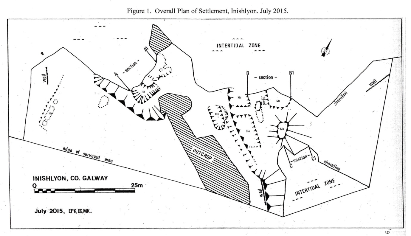
Over three days (21–23 August 2018) a quantity of loose, recently wave-deposited, rounded, water-rolled stones were removed from a sunken rectangular feature, probably the remains of a house, located on the edge of a beach (identified as (H3) on the site plan).
Though badly damaged by coastal erosion, the removal of surface stones and loose sand revealed three side walls of a sunken dry stone rectangular structure, cut into sand and located immediately beside a shingle bank on the west shore of Inishlyon, County Galway. The bottom courses of the walls survive in part and the structure measures 3.2m x 4.6m in plan internally. The long axis of the building is north-west/south-east. This may not be the full extent of the original building. One stone laid on its side and slightly displaced, lying roughly north-east/south-west, appears to be all that remains of the end wall at the north-west, however this requires further investigation. Part of a ramped entrance, orientated east-north-east to west-south-west, is cut into sand and is lined with dry stone. It meets the outside of the northern wall of the building towards the north-west. The ramp slopes slightly to meet the north-west/ south-east wall of the building and measures 3.1m long. The average thickness of the wall of the building is 0.5m. The entrance to the building is 0.9m wide. A drystone wall which defines the ramp at south is a revetment, built up against a sand bank. If there was a wall lining the northern side of the ramp, it no longer survives. The ramp appears to have been in-filled with stones and sand. What appears to be a partly collapsed, stone-lined drain, edges the north-eastern edge of the stone ramp and runs north-west/south-east and at right angles to the ramp. The drain separates the ramp and the associated building from a mound containing midden material (M1).
The rectangular building sampled in 2018 (H3) backs on to a slightly raised and grassed over, 1m wide, 4m long bank. This bank divides this building from another sunken structure (H4), immediately to the east. Two mounds (M1) and (M2) containing midden material of 19th-century date abut both (H3) and (H4). They are separated only by a north-west/south-east running drain. House 3 (H3) is similar in form to two other sunken features in immediate proximity, identified as (H1) and (H2), which were sampled in 2015, 2016 and 2017. These nearby features are probably the remains of two single-roomed sunken houses.
Finds from the building (H3) and from the ramp, include 19th-century pottery and fragments of glass bottles. Finds eroded from the middens include fish bones and shellfish. Combined with fish bones from the associated middens, the presence of a stone fishing weight found within (H3) indicates fishing as an occupation here, as one would expect. The surface pottery and other material so far found indicates that this feature, like nearby (H1) and (H2), is likely to be a house used in the 19th century. This building is larger than the two rectangular buildings (H1) and (H2) which were sampled and surveyed in 2015, 2016 and in 2017. This (H3) may be the partial remains of the main building in this complex of relatively small sunken houses. Although charcoal was present immediately outside the building at the edge of the ramp, it is possible that this is from an earlier occupation horizon. No hearth has been identified as yet in (H3). There are flecks of charcoal and loose burnt stone present within the building along the south-eastern wall. This may indicate the presence of a hearth along the base of that wall. Further sampling in 2019 may reveal the precise location of the hearth of feature (H3).
It is intended that further sampling of middens (M1), (M2) and (M3) will take place in 2019. The proposed sampling of Midden 3, which underlies House 1, is of particular interest. It is still subject to active erosion and no datable material has yet been identified from it, in order to ascertain whether this feature is related to the house which lies over it or not.
Initial funding for the project was provided through a Rescue Grant by the National Monuments Service in 2015 and subsequently through fundraising by the Inishlyon Project, East End, Inishbofin. Thanks is due to the Inishlyon Project Committee and Shareholders of Inishlyon and to the artists and writers who assist in the survey and sampling work each year. Post-excavation funding has been awarded to the Inishlyon Project by the BIM-managed Fisheries Local Area Group Development Scheme (FLAGS) 2016-2023. All the support is gratefully acknowledged. The accompanying Inishlyon Sunken Village Plan (2015) is used here as a guide to the location of features mentioned in the report.
Further reading:
Gibbons, E. 2017 (ed.), By the Water’s Edge – Ar Cholbha An Uisce, Exhibition Catalogue,Clifden Arts Festival. Published by The Inishlyon Project, Inishbofin,County Galway.

