2018:698 - COOLOCK: Tonlegee Road, Dublin
County: Dublin
Site name: COOLOCK: Tonlegee Road
Sites and Monuments Record No.: DU015-076003
Licence number: 17E0527
Author: Dominic Delany, Dominic Delany & Associates
Author/Organisation Address: Creganna, Oranmore, Co. Galway
Site type: Ecclesiastical enclosure
Period/Dating: Medieval (AD 400-AD 1600)
ITM: E 720236m, N 739373m
Latitude, Longitude (decimal degrees): 53.390813, -6.192328
Archaeological pre-development testing and excavation were carried out on a development site at Tonlegee Road, Coolock, Dublin 5, in September 2018. The development site is partly located within the area of archaeological constraint for DU015-076, an early Christian ecclesiastical site associated with St. Brendan of Clonfert and upon which now stands the mid-18th-century Church of St. John the Evangelist and its associated graveyard. A curving linear feature (Length 30m min.; Width 1.2-1.5m), interpreted as the north extent of an ecclesiastical enclosure, was uncovered in the area immediately north of the church grounds during previous archaeological testing at the site in October 2017 (2017:617). Preservation in situ was achieved by redesigning the services layout to avoid any impact on the feature.
A second phase of testing was carried out on 7 September 2018. This phase was focused within a proposed landscape area to the west of the church grounds where it was proposed to route a new foul sewer line to connect with the existing foul sewer for the Church Hall. Five short test trenches (3–5m long) were opened at 10m intervals across the route of the proposed connection to determine if the previously uncovered curvilinear feature extends into this area. The feature was uncovered in the northernmost trench. In the absence of any alternative route it was agreed that a 1m wide section of the feature should be fully excavated in advance of the development.
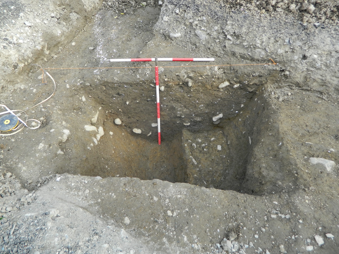
The excavation took place on 17 and 18 September 2018 and the curvilinear feature was revealed to be a ditch, 1.9m wide and 0.9m deep, with evidence of a re-cut on the south. The original ditch was U-shaped with steeply-sloping sides and a narrow base (Width c. 1.5m; Depth 0.9m) while the secondary cut had gently-sloping sides and an almost flat base (Width c. 1m; Depth 0.7m). The ditch contained a series of sandy/clayey silt fills with moderate-frequent inclusions of animal bones and shells. The animal bone consisted mainly of cattle, sheep/goat and pig, but also included a couple of horse and cat bones. Analysis of the assemblage revealed a mixture of butchery and kitchen waste indicating nearby slaughtering of animals (McCarthy, 2019). Cockle, mussel and winkle were the dominant shell types.
It was concluded that the curvilinear ditch uncovered during testing represents the north extent of the ecclesiastical enclosure around the Early Christian foundation on the site of the present Church of St. John the Evangelist. The arc of the uncovered section of ditch (Lenght 40m) indicates that the enclosure was oval in shape and orientated north-east/south-west. Neither the north-east or south-west extent of the enclosure is known but a small section of the south extent was excavated in 1990 (1990:033) and it would appear that the curvature of the south boundary wall of the existing graveyard also preserves part of the line of the south-west extent of the enclosure. Based on this evidence it is estimated that the north-south diameter of the enclosure is approximately 70m.
Reference
McCarthy, Margaret 2019, ‘Tonlegee Road 180527 – Report on Animal Bones’, unpublished report.