2018:660 - DUBLIN: Old St. George's Chapel, Hill Street, Dublin
County: Dublin
Site name: DUBLIN: Old St. George's Chapel, Hill Street
Sites and Monuments Record No.: DU018-020496
Licence number: 18E0688
Author: Judith Carroll, Judith Carroll and Company
Author/Organisation Address: Ballybrack Road, Glencullen, Dublin 18
Site type: Church
Period/Dating: Multi-period
ITM: E 716108m, N 735157m
Latitude, Longitude (decimal degrees): 53.353865, -6.255906
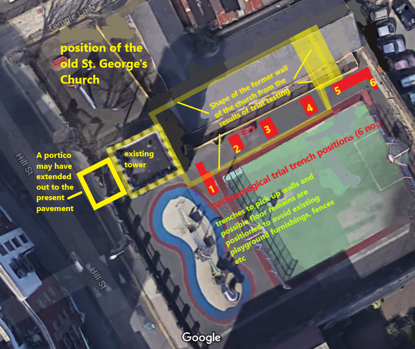
Trial testing was carried out on 22–23 November 2018 on the site of Old St. George’s Chapel in Temple Lane/Hill Street. The site is owned by Dublin City Council and comprises a family resource centre and playground. All that visibly remains of the former chapel is a stone tower, 5.9–6m square in plan.
It has been proposed to extend the Family Resource Centre or to replace it with a new building on a larger footprint. The Resource Centre is beside the tower on the west end (west-south-west) of the former St. George’s Chapel, while an adjacent graveyard is present to the south (south-south-east) of the chapel. The tower, DU18-020496, is National Inventory of Architectural Heritage reg. no. 50010958. It is Dublin City Council Record of Protected Structures no. 3880.
While the tower on the site is extant, the adjoining small church of St. George, built in the early 18th century (probably in 1718) by Sir John Eccles, was obliterated, probably when it was demolished in 1895. The graveyard clearly discontinued in use for further burials after that date as it is marked ‘Disused Graveyard’ on the late 19th-century OSI map.
There is, however, a good record of the church and its dimensions on the Fair Plan for the OSI map of 1846–7. The church was orientated lengthways south-south-east/north-north-west (called east-west here), with the tower to the west. The tower has a blocked-in doorway on its east side that would have connected it to the main church structure before its demolition. A small porch, from the evidence of the OSI map, probably extended out past the area of the present pavement, probably straight onto a more narrow (than at present) street or laneway which was later widened to form the present pavements of Hill Street.
The Family Centre is a modern building on the site which is situated partly on the footprint of the former chapel. To the south of the modern building is a children’s playground, on site of the former graveyard. The proposal to extend it was seen to possibly encroach on the old burial ground to the south-south-east of the demolished church. Both church and graveyard were, from existing records, built in the early 18th century and used into the late 19th century. The late date of the building would suggest it was unlikely that there was burial within the footprint of the former church, particularly as it was a small chapel building.
Trial testing was carried out on the basis of six test trenches to locate the position of the former south wall of the church as well as other information such as the presence of other features or burials within the church. The south wall of the church was found in Trench 1. A grave-slab base was found in Trench 5. This would have been attached to a slab and was clearly outside the church on its west side.
The wall was 0.85–0.87m wide north-south, It was found 0.86m in depth under rubble and clay and disused pipes which superimposed it under concrete. It was built of 4-5 courses of cut stone bound with mortar. The wall was 5.5m south of the family resource centre on its inner side. The position of the wall in relation to the tower can be compared to the Fair Plan for the OSI map of 1846–7 on which the church is shown. It can be estimated that the south wall of the church is 19.5m (north half with vestry) and 17.3m (south half) in length west of the existing tower.
Trenches 2–4 were dug to natural subsoil which was found at a depth of 1.5–1.6m. Clay was found under rubble which extended to a depth of 0.7–0.75m. This rubble superimposed a thin layer of concrete in Trench 4 while a layer of loose stone and mortar was found at the south end of Trench 2. This may have had to do with the collapse of the church wall, but the trench was not extended as the wall, at the time, was thought to be further south. Through all the trenches, there was no evidence of a church floor.
Fragments of human bone were found in Trench 2 as well as well as Trenches 1, 5 and 6. In the latter three trenches, these were quite extensive and were in the graveyard area outside the church. There were no burials in situ and the bone was fragmentary and unstratified.
Within the footprint of Old St. George’s Church, in Trench 2, where natural was reached at 1.5m, the small amount of human bone found and its absence from Trenches (1 and 3) would indicate that there were no burials within the church. The human bone found in Trench 2 originated in the disturbance of the site due to demolition of the former church and reconstitution of the site. Extensive burial, however, had clearly taken place in all areas outside the church and fragmentary disarticulated human remains came to light in all areas dug outside the footprint of the church.