2018:476 - SWORDS: Mooretown (Phase 1), Dublin
County: Dublin
Site name: SWORDS: Mooretown (Phase 1)
Sites and Monuments Record No.: DU011–145
Licence number: 18E0396
Author: Kim Rice, Courtney Deery Heritage Consultancy
Author/Organisation Address: Lynwood House, Balinteer Rd., Dublin 16, D16 H9V6
Site type: Excavation - miscellaneous
Period/Dating: Multi-period
ITM: E 716210m, N 747990m
Latitude, Longitude (decimal degrees): 53.469117, -6.249647
Monitoring of topsoil stripping was carried out over a seven weeks, from 7 August to 14 September 2018. The Mooretown development lands, which formerly comprised large tillage fields, are located due south of the Applewood Community Centre, Swords Educate Together and the Rathbeale Road.
The monitoring revealed archaeological features in Field 9 (Area 2), Field 10 (Area 3) and Field 12 (Area 4), as well as an area of possible potential in Field 6 (Area 1). No evidence for archaeological activity was identified in Field 11, which displayed evidence for modern disturbance. Areas 1–4 were more thoroughly investigated following the completion of topsoil stripping onsite. The key remit of the exercise was to establish the chronology, extent and character of the archaeological material, in order to inform methodological and research approaches for future preservation and/or excavation strategies.
The investigation demonstrated that there are extensive deposits of alluvial-derived clays in the northern end of Field 6. It was initially suspected that the strata were suggestive of a millrace and tail pond. However, no cuts or associated features were identified, and no finds were recovered. Consequently, it is more likely that this section of the field occupies the former course of a paleochannel. A prehistoric burnt spread and water pit were uncovered in Field 9 to the west, in addition to a cultural spread of medieval date. The spread is indicative of a midden that was probably associated with the medieval structure/mill that was identified during testing in 2008 and was located c. 30m to the north-west.
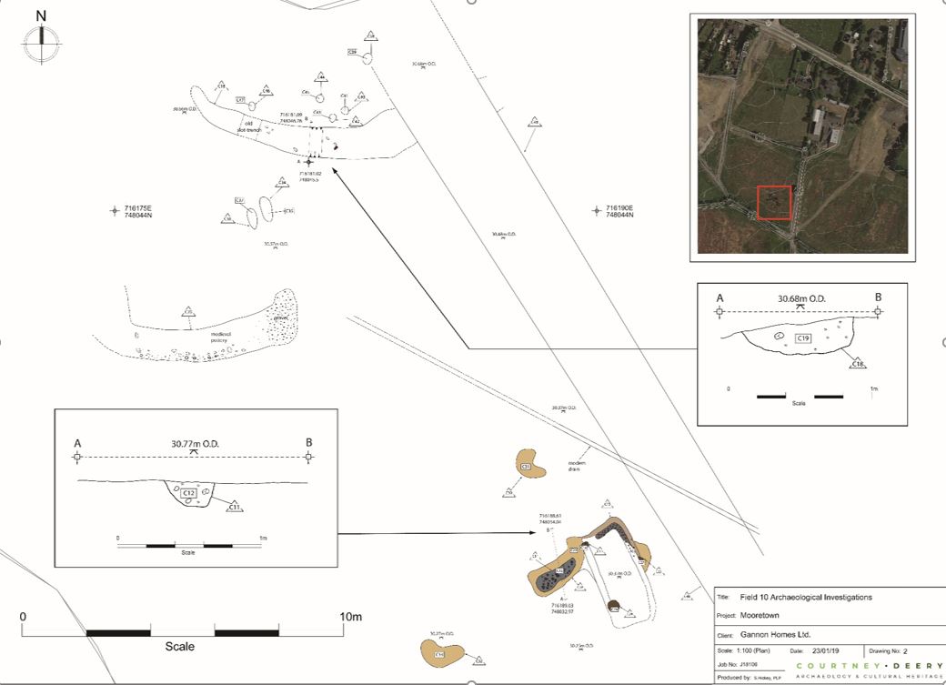
The remains from Field 10 included a possible prehistoric structure, two medieval curvilinear features, a post-medieval ditch and agricultural features, in addition to a series of pits and post-holes. The possible structure incorporated evidence for in situ burning and produced sherds of prehistoric pottery and struck flint, while an assemblage of local medieval wares were recovered from the two curvilinear features to the north-west. Further evidence for prehistoric activity was identified to the east in Field 12, where two pits containing burnt bone, lithics and Beaker pottery were uncovered.
A buffer zone was placed around Areas 2–4 and they were fenced-off to protect them from construction activity. The three areas were covered with geotextile and a protective layer of topsoil was backfilled over them. Thus, they will not be impacted upon or disturbed until a decision is made regarding whether the sites will be preserved in situ, or will be excavated.